

Tag: OSM
-
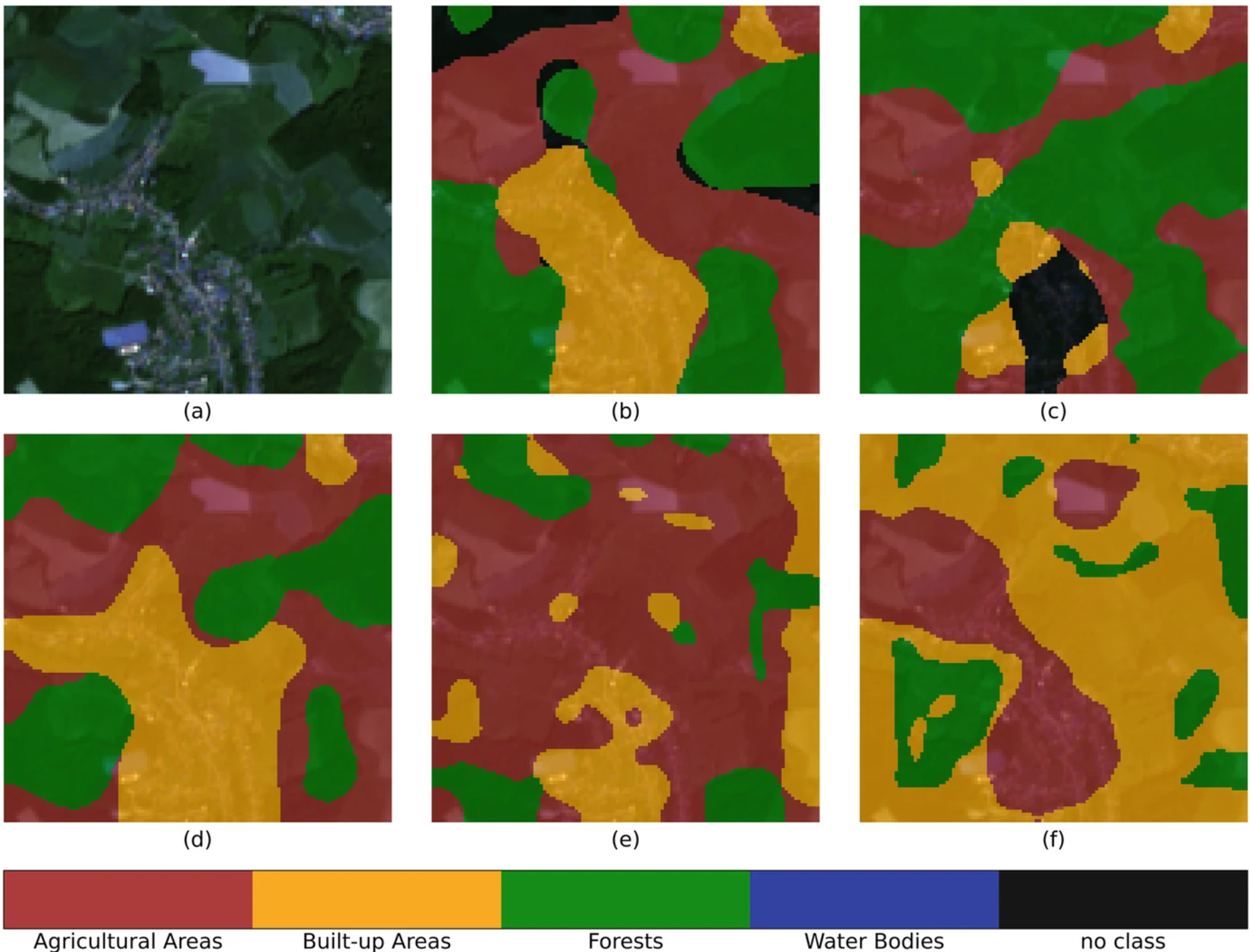
IDEAL-VGI: Analyzing and Improving the Quality and Fitness for Purpose of OpenStreetMap as Labels in Remote Sensing Applications
We are happy to announce that the IDEAL-VGI project by GIScience has been successfully completed. IDEAL-VGI was a tandem project in cooperation with Begüm Demir from the TU Berlin and was conducted under the umbrella of the VGIscience Second Phase Projects which ran from 2020 to 2022. VGIscience received funding as a Priority Programme by…
-

Spotlight on HeiGIT’s FOSSGIS 2024 Presentations
We’re thrilled to share some exciting news – our colleagues Julian Psotta and Benjamin Herfort are set to deliver talks at FOSSGIS 2024 in Hamburg, Germany! Julian Psotta will be presenting the openrouteservice project together with the Federal Agency for Cartography and Geodesy (BKG). Their joint talk “From openrouteservice to RoutingPlus – Insights into a…
-
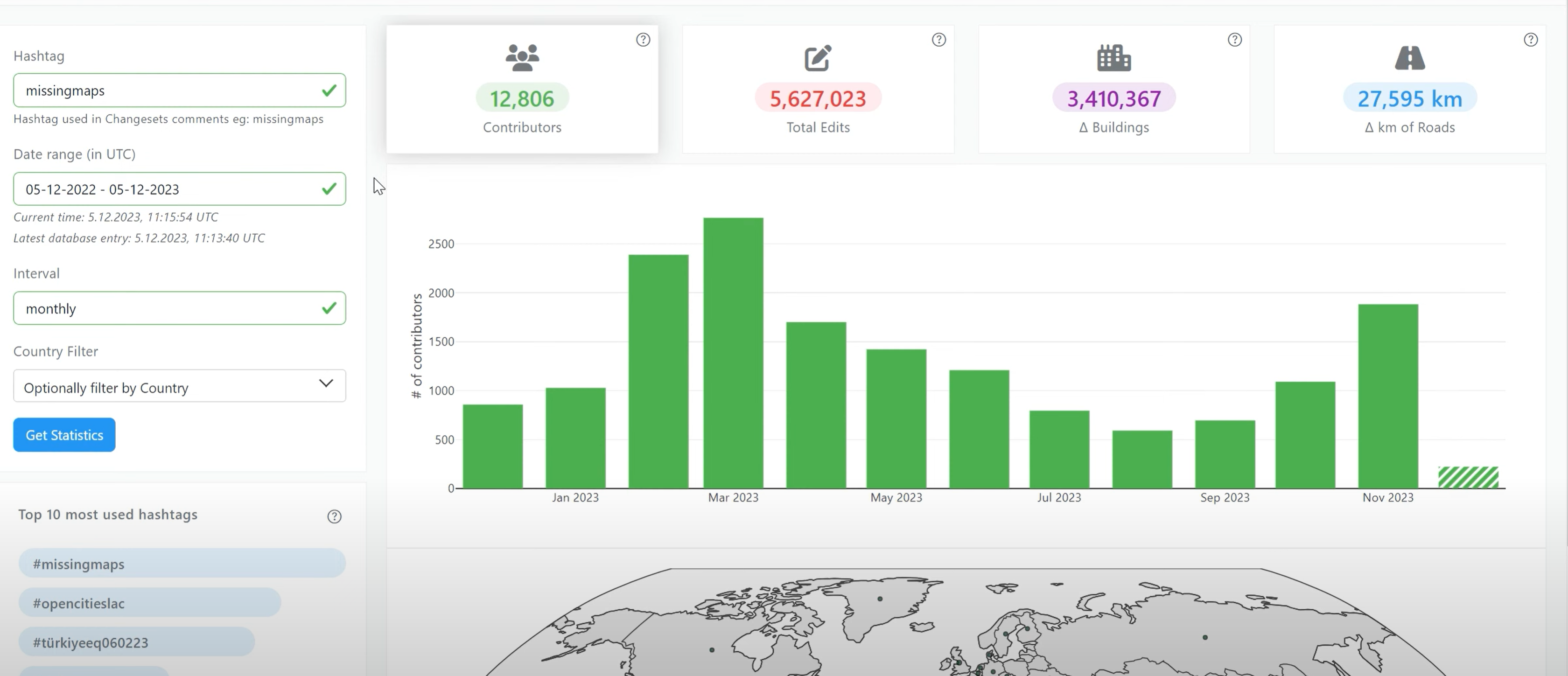
Introducing OhsomeNowStats
OhsomeNowStats allows users to take a look at the mapping activity in OpenStreetMap. This is especially useful for humanitarian organizations and mapathon organizers, because OhsomeNowStats data is updated every 5-10 minutes. Using this tool, user-engagement can be tracked in near real time and used to motivate participants and volunteers alike! By selecting a time range,…
-
The Year 2023 at HeiGIT
As 2023 is coming to an end, we would like to take the opportunity to look back at this eventful year and appreciate the advance that HeiGIT has made towards its goal of enabling and improving the transfer of knowledge and technology. Thanks to the collective efforts of each team member and the GIScience community,…
-
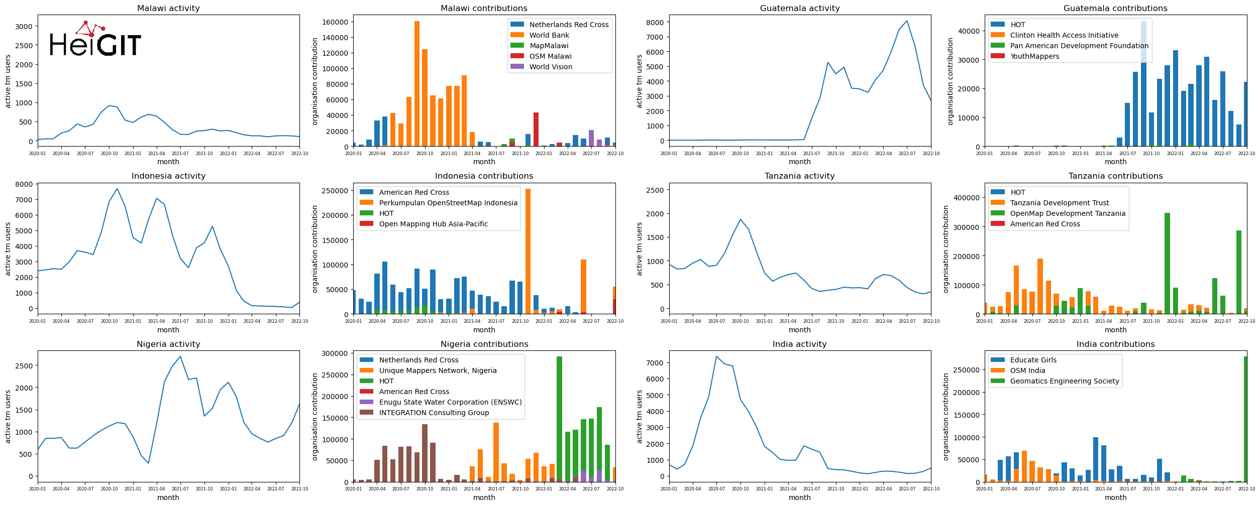
Analysis of Humanitarian OSM Stats: User activity through HOT-TM and contributing organizations
Introduction In this blogpost we are taking a look at humanitarian mapping through the Tasking Manager (HOT-TM) that is operated by the Humanitarian OpenStreetMap Team (HOT). At HeiGIT we work together with HOT to provide analyses and statistics to further understand mapping activity. Explore the user and mapping stats of all Tasking Manager activites here. Check our blog posts about topics…
-

HeiGIT at State of the Map Europe 2023
This year’s State of the Map Europe Conference (SotM EU) took place in Antwerp, Belgium. HeiGIT’s Benjamin Herfort and Jochen Stier visited the conference. SotM is a platform hosting OSM mappers, open-source developers, researchers, GIS professionals, cartographs and many more interested people. The goal is to offer an opportunity for those groups and individuals to…
-
Exploring the Value of Microsoft ML Roads for OSM Data Quality Analysis
The completeness of the OpenStreetMap (OSM) road network has been an ongoing focus for researchers for more than 15 years. For instance, Neis et al. (2011) investigated the OSM street network evolution in Germany and compared it against road data from TomTom. Whereas obtaining reference data has been rather difficult in the past, nowadays we…
-
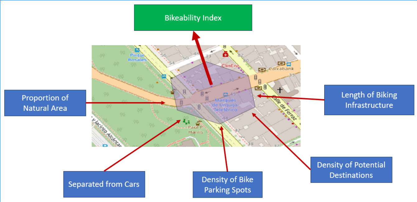
Analyzing Bikeability
For various reasons biking is becoming a more frequently used mode of transportation. It offers flexibility, is quite cheap compared to other modes of transportation, helps with fitness and is almost carbon neutral. To evaluate how well adapted the existing infrastructure is to accommodate biking, Manuel Kraft of HeiGIT created the “Bikeability-Index”. Analyzing Bikeability There…
-
SketchMapTool Enters Next Phase with Funding from German Red Cross and German Federal Foreign Office
The Sketch MapTool (SMT) is entering its next project phase thanks to support from the German Red Cross (GRC) and the German Federal Foreign Office. In this phase, our main goals are enhancing the tool’s stability and marking detection, as well as expanding the current features, adding new languages and satellite imagery as base maps.…
-
Expanding Disaster Management Capabilities with openrouteservice
In the context of disaster management, time is of the essence. Quick and accurate response can make all the difference in saving lives and mitigating damage. That’s why the openrouteservice (ORS) for Disaster Management is taking a step forward by expanding its coverage to larger areas. This upgrade is set to improve the possibilities of…
-
HeiGITs Disaster Portal in Radiobeitrag vorgestellt
Campusreporter Nils Birschmann hat mit Prof. Alexander Zipf über unser Disaster Portal gesprochen. Das Interview wurde über Radio Regenbogen ausgestrahlt. Hier könnt ihr euch den Beitrag in voller Länge anhören: Audiobeitrag: Das Disaster Portal – sichere und schnell verfügbare Datengrundlagen im Katastrophenfall Darum geht’s: Im Katastrophenfall sind Hilfskräfte auf aktuelle Ortsdaten der betroffenen Region angewiesen: Welche…
-
Bachelor’s thesis: Using OSM for location analyses of residential real estate projects – an extrinsic analysis of data quality
In his bachelor’s thesis, supervised by HeiGIT’s apl. Prof. Dr. Sven Lautenbach, Lars Reckhaus examined the suitability of OpenStreetMap (OSM) for location analyses in the context of residential real estate projects. Typically, such analyses require the use of a variety of data sources and are mostly performed manually. For this reason, they tend to be…