

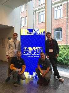
This year’s State of the Map Europe Conference (SotM EU) took place in Antwerp, Belgium. HeiGIT’s Benjamin Herfort and Jochen Stier visited the conference. SotM is a platform hosting OSM mappers, open-source developers, researchers, GIS professionals, cartographs and many more interested people. The goal is to offer an opportunity for those groups and individuals to meet and exchange their knowledge and experiences.
HeiGIT contributed with a workshop “Introducing the ohsomeNow stats dashboard – a workshop for measuring your impact” a talk “Global and regional level of use of buildings and roads prepared by AI for OSM Mapping” and two lightning talks “OpenStreetMap Data for Automated Labelling Machine Learning Examples: The Challenge of Road Type Imbalance” and “Exploring Road and Points of Interest (POIs) Associations in OpenStreetMap, A New Paradigm for OSM Road class Prediction” handed in in collaboration with the GIScience department at the Institute for Geography at Heidelberg University. Jochen Stier put his first visit to a SotM EU Conference into words: “SotM was pretty cool! It was awesome to see how OSM data is used in so many areas, not just in academia. Also our tools got regular shoutouts, especially in the academic discussions. On the other hand, there were some discussions, where the participants had questions that could have easily been answered by some of our tools, if they had known about them.” For example, information about public transport in Antwerp was outdated or incomplete and a participant wished for a tool that quickly shows how much of the public transport system was edited in OSM more than 5 years ago. This question can easily be answered by HeiGIT’s OSM quality analysis toll oqapi integrated in the ohsome-dashboard (see below).
HeiGIT’s contribution
“Introducing the ohsomeNow stats dashboard – a workshop for measuring your impact” by Benjamin Herfort (HeiGIT), Nicole Siggins (Humanitarian OpenStreetMap Team)
The ohsomeNow stats dashboard and API provide up-to-date and global scale overview statistics on mapping activity in OpenStreetMap. Participants learned what the new dashboard is, about its background and how to use it to measure their impact across OSM.
Global and regional level of use of buildings and roads prepared by AI for OSM Mapping by Benjamin Herfort (HeiGIT), Milan Fila (Masaryk University), Radim Štampach (Masaryk University)
Despite the hard work of volunteers, OpenStreetMap is still poorly mapped in many parts of the world. Using AI-assisted tools was seen as one possibility to fill data gaps. The goal was to search the actual level of AI-assisted mapping and show the overall global level and highlight differences between countries and regions and their temporal evolution. In 2021-2023, a minimum of 5.6% of buildings and 0.8% of principal roads newly created in OSM came from AI-assisted mapping workflow.
OpenStreetMap Data for Automated Labelling Machine Learning Examples: The Challenge of Road Type Imbalance by Edson Augusto Melanda (Federal University of São Carlos, University of Heidelberg) Benjamin Herfort (HeiGIT), Veit Ulrich (University of Heidelberg), Francis Andorful (University of Heidelberg), Alexander Zipf (University of Heidelberg, HeiGIT).
Exploring Road and Points of Interest (POIs) Associations in OpenStreetMap, A New Paradigm for OSM Road class Prediction by Francis Andorful (Heidelberg University), Christina Ludwig (Heidelberg University).
Using oqapi to evaluate completeness and currentness of highway=bus_stop and railway=tram_stop in Antwerp
Bus stops
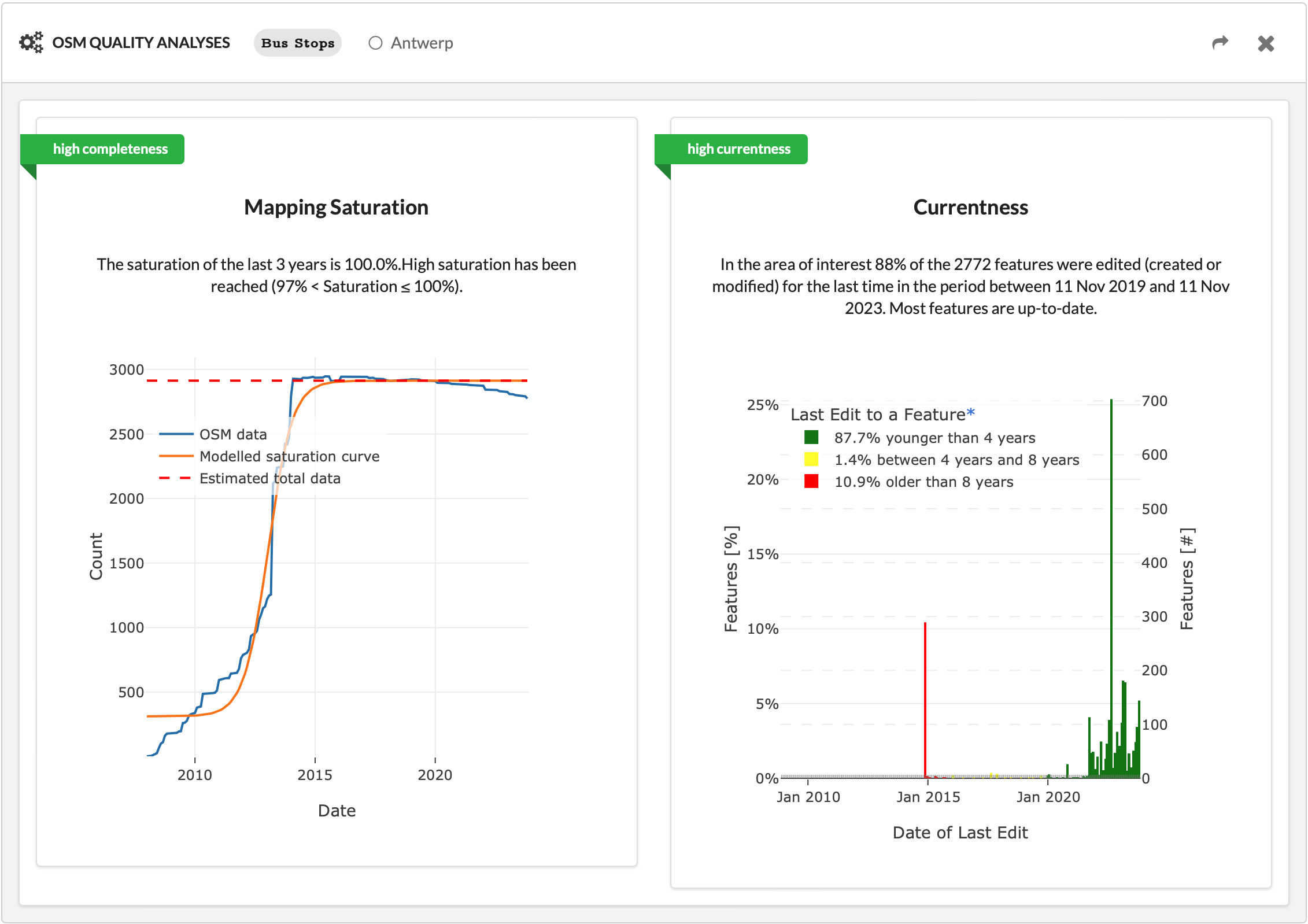
Recreate the query here.
Tram stops
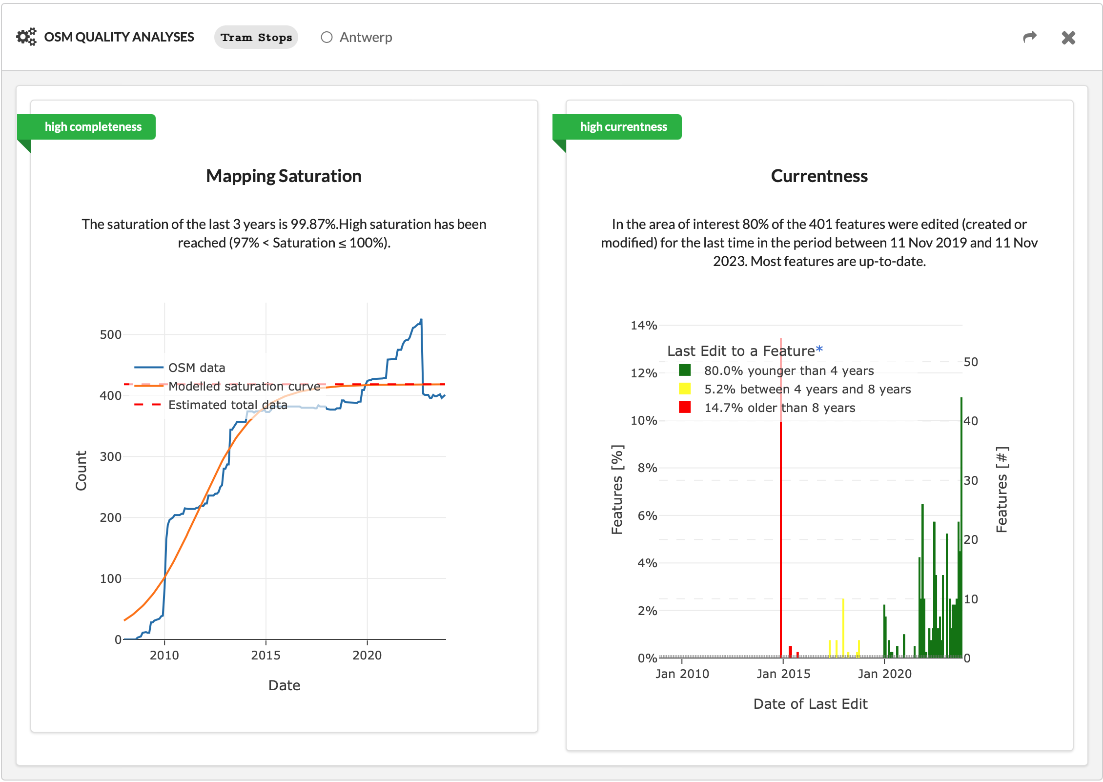
Recreate the query here.