

Author: Dominik Neumann
-
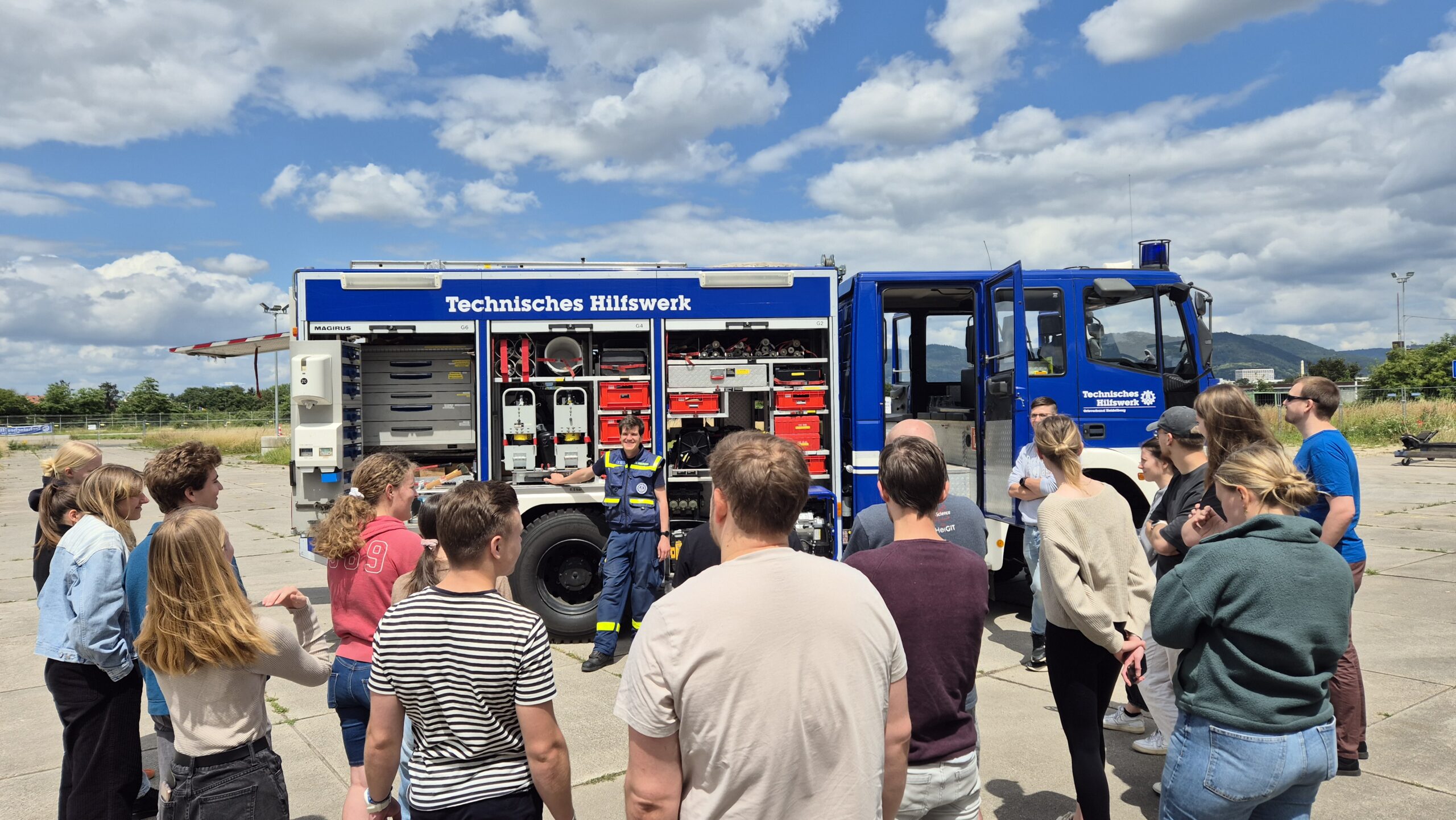
GIS for Disaster Response: A Field Trial by the University of Heidelberg
Two weeks ago, as part of a seminar on GIS for Disaster Risk Reduction led by HeiGIT employees, students from Heidelberg University tested several HeiGIT services in a field test. The focus was on the following applications: openrouteservice, the disaster portal and the Sketch Map Tool. In cooperation with the THW local branch in Heidelberg,…
-
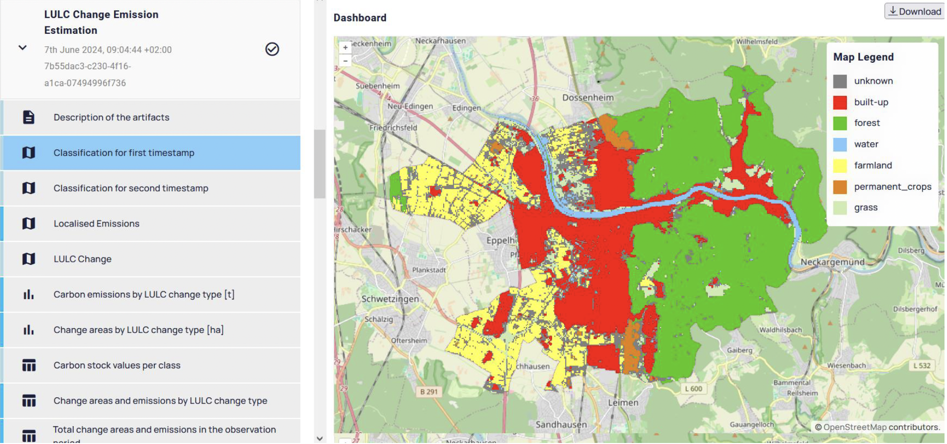
Quantifying CO2 Emissions from Land Use Changes
The role of land use changes in generating CO2 emissions is a crucial aspect in the fight against climate change. These emissions are the second-largest source of anthropogenic greenhouse gases, following energy production and usage. Given the urgent need to meet climate targets, especially the goal of achieving climate neutrality by 2040, detailed quantification of…
-
Enhancements in the QGIS Plugin for openrouteservice
The openrouteservice (ORS) QGIS plugin continues to evolve, bringing a suite of new features, improvements, and fixes that enhance its functionality and user experience. This update incorporates significant changes that will benefit users working on diverse geospatial projects. In this post, we highlight the key updates in the latest version of the ORS QGIS plugin.…
-
Evidence for Systematic Bias in the Spatial Memory of Large Language Models
Recent studies primarily view Large Language Models (LLMs) in geography as tools for linking natural language to geographic information systems. However, Roberts et al. (2023) demonstrated GPT-4’s inherent ability to perform spatial reasoning tasks without relying on external processing engines. This includes calculating the final destinations of routes based on initial locations, transport modes, directions,…
-
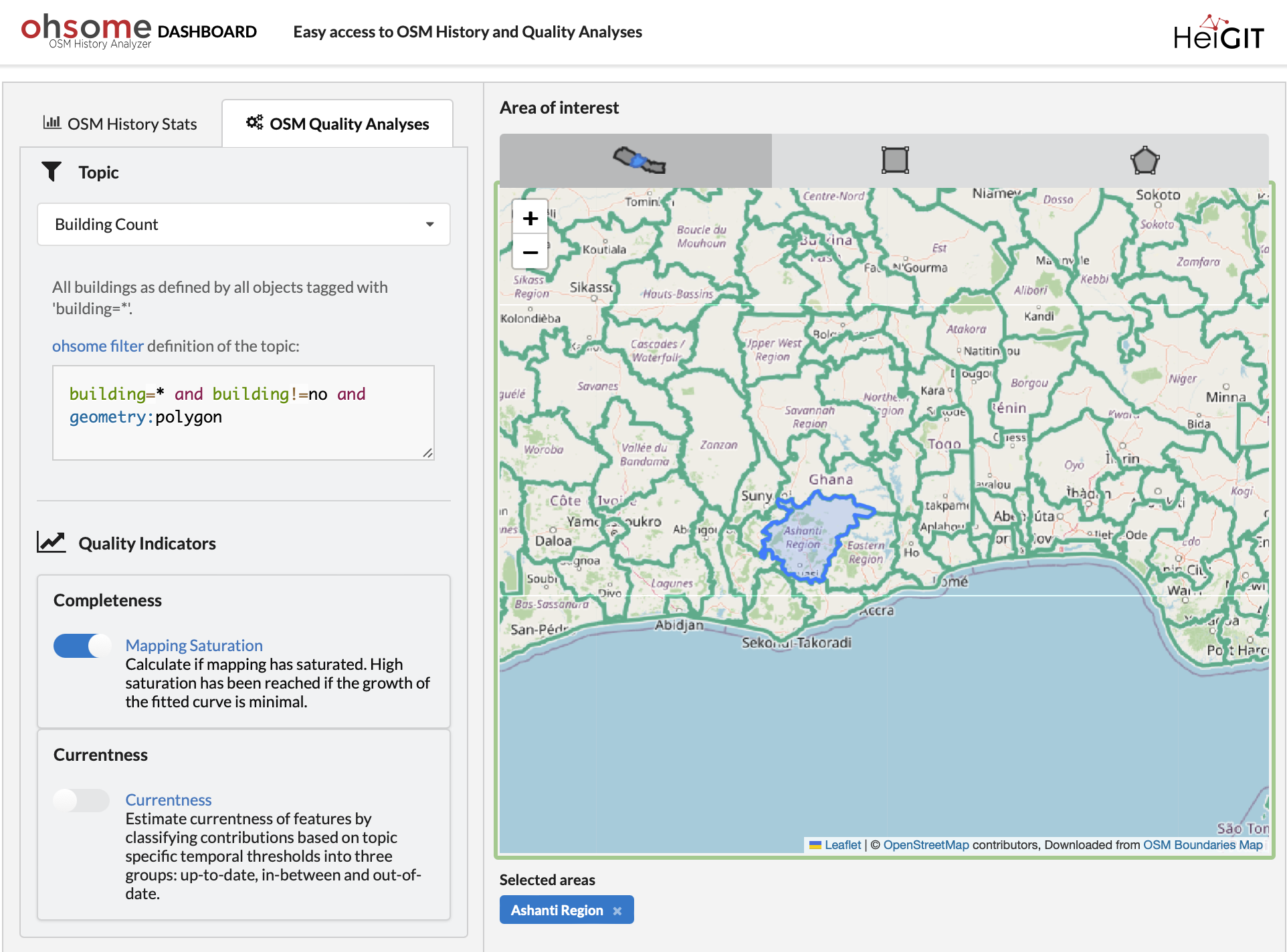
ohsome Quality API: New Features
Are you ready to take your OpenStreetMap (OSM) data analysis to the next level? We’re excited to showcase the latest features of our ohsome Dashboard, designed to provide you with insights into OSM data quality. With the ohsome Dashboard, analyzing OSM data has never been easier. Whether you’re interested in evaluating mapping saturation, currentness, or…
-
Mapping Progress in Real Time: Highlights from GeoNight 2024 Mapathon with HeiGIT and Mannheimer Mapathons
During GeoNight 2024, HeiGIT partnered with Mannheimer Mapathons to host a mapathon together. Mapathons are events where volunteers come together to map crucial features like roads, buildings or waterways on OpenStreetMap, often in response to specific needs or crises, such as post-earthquake or post-flood scenarios. We were privileged to connect with volunteers from OSM Ghana, gaining insight into…
-
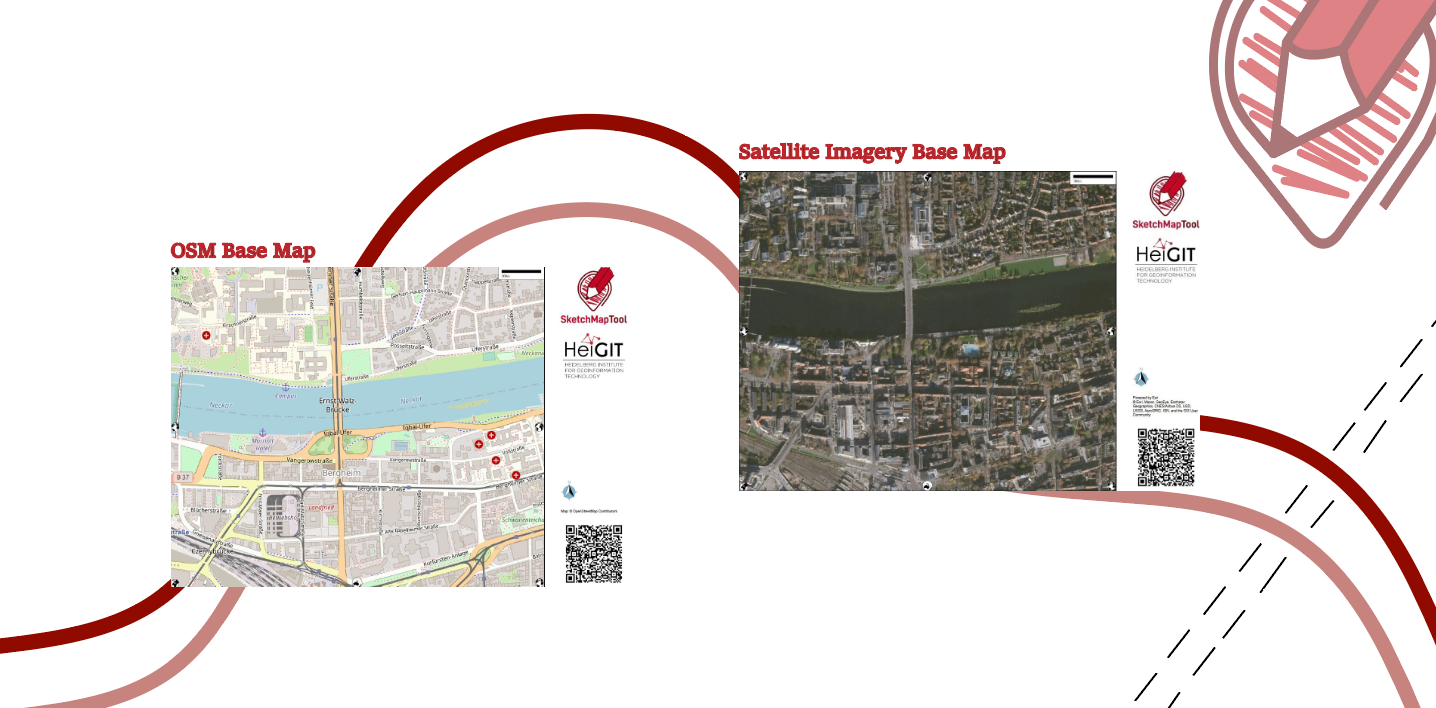
Unveiling the Sketch Map Tool 2.0: A Comprehensive Overview of New Features and Training Opportunities
The HeiGIT gGmbH (Heidelberg Institute for Geoinformation Technology) team has just released a version 2.0 of the Sketch Map Tool, a low-tech solution for participatory sketch mapping through offline data collection, digitization and georeferencing of local spatial knowledge. Thanks to continuous support from the German Red Cross and financial support by the German Federal Foreign Office, the HeiGIT tool has undergone significant enhancements. These updates introduce new features aimed…
-
HeiGIT at FOSSGIS 2024
We’re proud to share our recent conference experience with you! Our HeiGIT Product Owners for Big Data and Smart Mobility, Benjamin Herfort and Julian Psotta, had the privilege of attending the FOSSGIS 2024 conference, where they contributed valuable insights and expertise. The results of an exciting six years of joint work and shared projects between HeiGIT and the Federal Agency for Cartography…
-
GeoPrompt – Revolutionizing Navigation and Beyond: HeiGIT’s Innovative Web Application Powered by ChatGPT
Introduction In an era where technology continuously reshapes our world, the fusion of artificial intelligence and geospatial data offers exciting possibilities. HeiGIT (Heidelberg Institute for Geoinformation Technology), a pioneering research organization, has unveiled a novel web application that not only simplifies navigation but also empowers users to access a wealth of location-based data. This proof-of-concept…
-
OQT for Food Environments
HeiGIT and the Amsterdam University Medical Centers (UMC) partnered up to investigate food environments through the lens of OpenStreetMap (OSM) data. UMC analyses how exposure to different categories of food related retailers affects health matters. The assumption is that the distance to retailers of a certain category, as well as the number of these retailers,…
-
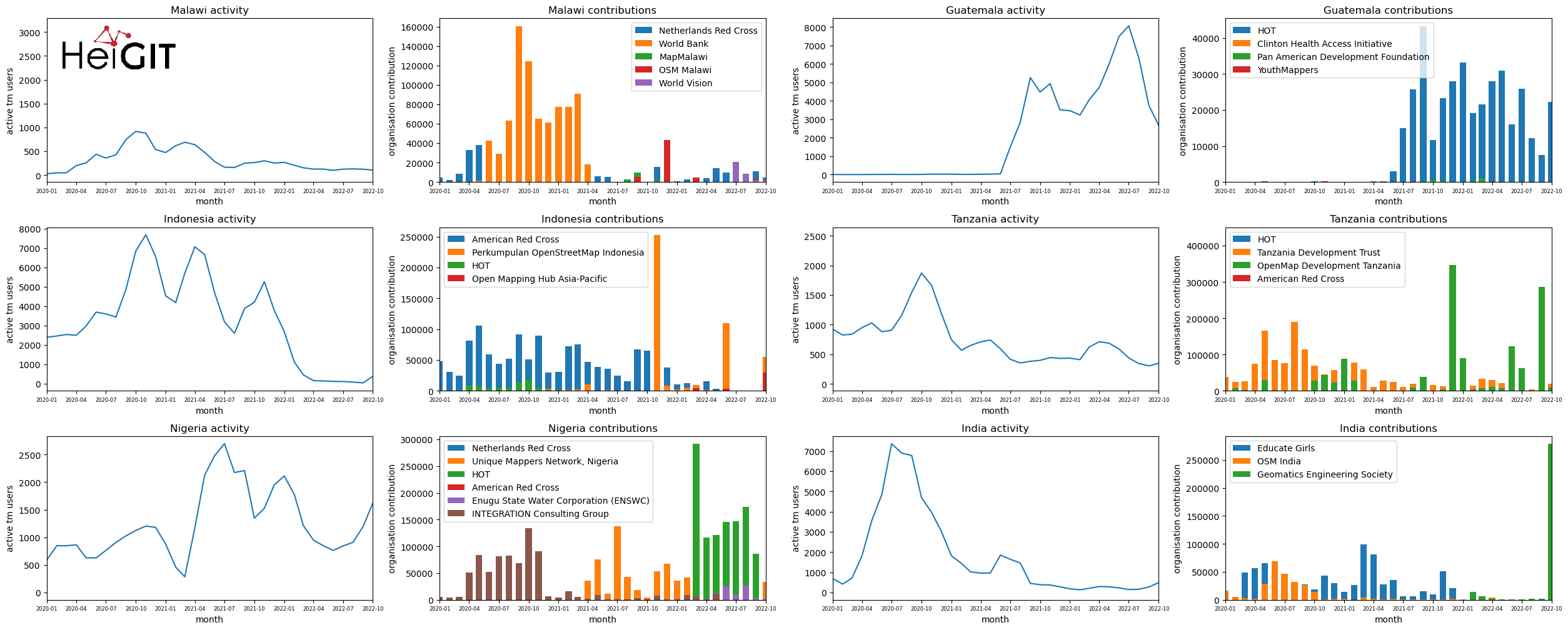
Analysis of Humanitarian OSM Stats: User activity through HOT-TM and contributing organizations
Introduction In this blogpost we are taking a look at humanitarian mapping through the Tasking Manager (HOT-TM) that is operated by the Humanitarian OpenStreetMap Team (HOT). At HeiGIT we work together with HOT to provide analyses and statistics to further understand mapping activity. Explore the user and mapping stats of all Tasking Manager activites here. Check our blog posts about topics…
-
HeiGIT at State of the Map Europe 2023
This year’s State of the Map Europe Conference (SotM EU) took place in Antwerp, Belgium. HeiGIT’s Benjamin Herfort and Jochen Stier visited the conference. SotM is a platform hosting OSM mappers, open-source developers, researchers, GIS professionals, cartographs and many more interested people. The goal is to offer an opportunity for those groups and individuals to…