

Author: Dominik Neumann
-
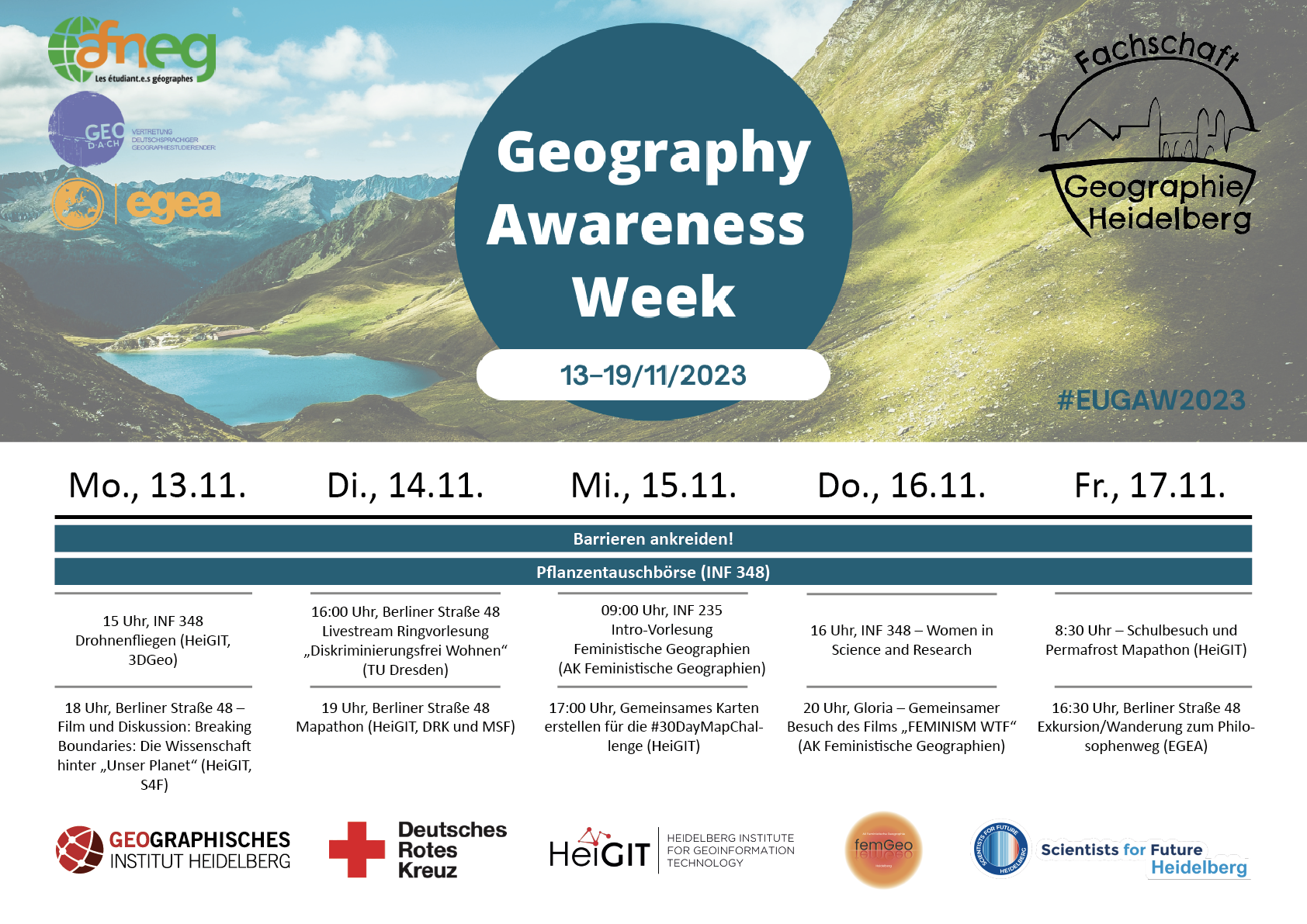
HeiGIT participates at this year’s Geography Awareness Week
In the upcoming week, 13th – 17th November, the annual Geography Awareness Week will take place. The theme week, organized by the National Geographic Society, aims to show the importance of geography in many areas of everyday life and the opportunities this discipline offers to tackle key challenges such as climate change. HeiGIT organizes and participates in…
-
HeiGIT contributes to German Congress for Geography and Young Congress for Geography 2023
From 19th until 23th September 2023 the 62nd German Congress for Geography (DKG) and Young Congress for Geography (JGK) will take place at the Goethe-Universität Frankfurt. The congress under the motto “Planetary Futures” aims to become a lively and vibrant place for scientific exchange on current issues, important research questions and societal problems. HeiGIT will contribute with…
-
Version 1.0 of the ohsome quality API and ohsome dashboard
At HeiGIT and in particular within the ohsome team, we strive to provide valuable insights into OpenStreetMap (OSM) data. The ohsome API offers aggregated statistics on the evolution of OSM elements since 2020. These are made easily accessible by the ohsome dashboard. With the ohsome quality API, previously called ohsome quality analyst (OQT), we continue…
-
Bachelor’s thesis: Using OSM for location analyses of residential real estate projects – an extrinsic analysis of data quality
In his bachelor’s thesis, supervised by HeiGIT’s apl. Prof. Dr. Sven Lautenbach, Lars Reckhaus examined the suitability of OpenStreetMap (OSM) for location analyses in the context of residential real estate projects. Typically, such analyses require the use of a variety of data sources and are mostly performed manually. For this reason, they tend to be…
-

Introducing ohsomeNow stats: Real-Time Monitoring for OpenStreetMap Contributions
You can now monitor contributions to OpenStreetMap (OSM) in real time with ohsomeNow stats! We developed this new dashboard as part of our long-term cooperation with the Humanitarian OpenStreetMap Team (HOT), an international organization dedicated to humanitarian action and community development through open mapping. This dashboard replaces the Missing Maps Leaderboard with a comprehensive overview of…
-
Recap Road Quality Mapathon
Last Monday, on July 31st, we hosted a road quality mapathon, which saw the participation of students and researchers alike. Their collective efforts led to the classification of nearly 50% of all the pre-selected road pictures in 34 African countries. These valuable data points will be instrumental in training machine learning algorithms to identify paved…
-

Advancing Geospatial Techniques for Vector-Borne Disease Research: Insights from GIScience-CSIAD Collaboration – a conference recap
Recently, Hanse-Wirtschaftskolleg hosted its meeting which brought together experts from GIScience and CSIAD lab, along with renowned researchers from universities in Germany, Thailand, and Ghana, serving as a platform for interdisciplinary collaboration on vector-borne diseases. This event brought together esteemed researchers to share their expertise and insights into combating mosquito-borne illnesses. As an invited speaker,…
-
Join the team: Public Relations Manager (m,f,d) up to 100%
Do you want to use your know-how and experience in science communications, digital marketing, and international outreach for the benefit of society and the environment? Help us at HeiGIT as we innovate towards that goal! We need your expertise to strengthen our outreach and partner network so that organizations and people in need can learn about our geospatial…
-
Integration of OQT into the ohsome dashboard: Computing data quality metrics for OpenStreetMap
The ohsome dashboard has been and continues to be an easy access point to generate accurate statistics about the historical development of OpenStreetMap data for arbitrary regions. Now, the ohsome dashboard got extended to be able to compute data quality metrics for OpenStreetMap through the ohsome quality analyst (OQT) which is also developed by HeiGIT. The source code is now…
-
Unleashing the Power of AI-Assisted Mapping in OpenStreetMap? – a webinar with HOT and Masaryk University
The ever-increasing volume and speed of corporate or machine learning-assisted mapping present unique challenges for individual volunteer mappers, particularly in terms of monitoring and validation. While the global impact and evolution of AI-assisted mapping in OpenStreetMap (OSM) remain largely unknown, there is a need to engage with mappers to understand their perspectives on this emerging…
-
Workshop on Intelligent Systems for Vector-Borne Disease at HWK
Heidelberg as a GeoHealth Hub: GIScience team member Steffen Knoblauch was invited by the Hanse-Wirtschaftskolleg to an event of the working group for Intelligent Systems for Vector-Borne Disease. Various sessions will be held, amongst others the session about Mosquito Monitoring first thing tomorrow. At 11 am Steffen will talk about “Key drivers for inner-urban dengue occurrence” during the Mosquito Monitoring session. He will elaborate…
-
OSM Element Vectorisation Tool Version 1
The IDEAL-VGI research project is nearing its end. And while that won’t be the end of our research into social data sources, data quality analyses and land-use information, we are happy to announce a major outcome: the version 1 release of the OSM Element Vectorisation Tool (OEV). The tool was first presented to the public…