

Tag: heigit
-
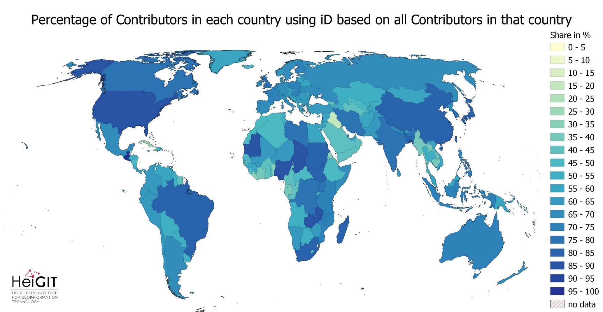
Exploring OSM editor statistics by combining data from OSHDB and changeset DB
OpenStreetMap (OSM) marks one of the most successful and powerful open source, crowdsourced geomaps, with over 10 million registered users by 2023. Since 2008 this number has increased steadily. In this blog post we want to look behind this success from the perspective of editing software used to add, modify and delete data in OSM.…
-

HeiGIT at Summer School Disaster Risk Reduction 2023
Today we’d like to tell you about the Summer School Disaster Risk Reduction 2023 event hosted by the Environmental Campus of UAS Trier in Germany and organized by the German Committee for Disaster Reduction (DKKV). During this one-week course that took place from the 9th till the 15th of July 2023, students and people interested…
-
Activation of the Disaster Portal for the earthquake in Türkiye/Syria
During catastrophic events such as the recent Türkiye/Syria earthquake, the road infrastructure in the affected area is often widely interrupted and accessibility varies over time. Inspite of this, it is imperative to quickly provide assistance to the affected people. Humanitarian Organizations need real-time information for force and logistics planning: Which roads are still passable? How…
-
Cooperation between HeiGIT, the German Red Cross and the German Aerospace Center
Welche Gebäude sind nach einem Erdbeben am schwersten beschädigt? Welche Gegenden haben keinen Zugang zu Gesundheitseinrichtungen? Wie verändert sich die Routenplanung und somit die Notfallversorgung, wenn bestimmte Straßen und Brücken nicht nutzbar sind? Das Heidelberg Institute for Geoinformation Technology gGmbH (HeiGIT) arbeitet seit einigen Jahren mit dem Deutschen Roten Kreuz (DRK) und mit dem Deutschen Zentrum für…
-
OSHDB Version 1.0 Has Arrived
Featured Photo: Ohsome dashboard interface for Heidelberg, Germany. In the words of Confucius, “The man who moves a mountain begins by carrying away small stones.” As we release OSHDB (OpenStreetMap History Database) Version 1.0, we look back at versions 0.5, 0.6, 0.7, and all the other small improvements to our historical OpenStreetMap database as the…
-
Geography Awareness Week 14.-19.11.2022
Der Klimawandel, Grenz- und Wasserkonflikte stellen enorme Herausforderungen für die aktuelle und kommenden Generationen dar. In all diesen Bereichen und darüber hinaus bietet die Geographie einmalige Chancen, zielgerichtet Lösungen zu erarbeiten. Das Geographische Institut der Universität Heidelberg möchte gemeinsam mit der Fachschaft Geographie, dem HeiGIT(Heidelberg Institute for Geoinformation Technology), GeoDACH e.V. und anderen internationalen Partnerorganisationen Aufmerksamkeit auf das Fach Geographie und…
-
Time to celebrate! oshdb has reached an object count of >10 billion!
As of 02.11.2022 we have reached objects 10,107,826,483* in our oshdb. As such, we think it is most definitely time to celebrate! *For information on the background this figure, read our Basic guide to OSM data filtering 😉 This blog post is all about reaching 10 billion objects in OpenStreetMap. For the database to aggregate such…
-
Near realtime OpenStreetMap data and stats: OSHDB and ohsome API are now updated hourly
We have exciting ohsome news! As many of you know, past OSHDB updates happened weekly and led to a delay between the data in OpenStreetMap (OSM) and our database. Basically, you had to wait up to a week to see changes in OSM reflected in the OSHDB. From this point forward, that lag is a…
-
ohsome Region of the month – Temporal OSM developments in Kyiv
Welcome back to our ohsome region of the month series! In this post, we’ll take a look at the temporal development of highways and added smoothness-information, as well as social facilities and updates on map development for Kyiv. Before we start, if you’re new to the series, make sure to check out previous installments of…
-
How to become ohsome part 14 – Advanced dashboarding
Hello again and welcome back to our “How to become ohsome” series where we demonstrate how you too can become ohsome with ohsome API! If you’re new to the series or need a refresher, check out the older installments in our series, like this or this one covering the various ways of accessing ohsome API. And now to our…
-
How to become ohsome part 13 – An ohsome way to check if OSM is up to date
At long last, welcome to another addition of our How to become ohsome-series! This one is special because we’re discussing a third-party application that uses ohsome API as back-end to accumulate historical OSM data. Although this innovation isn’t directly about our API, it’s close enough (and exciting enough) to merit inclusion and just one more opportunity for…
-
ohsome Region of the Month: hiking-related tags & mountains
Welcome back to a new installment of the ohsome Region of the Month blog series! This will be part two our posts on hiking related tags and this time, we’ll investigate the connection between user activity and said tags. To do this, we’ll use mountain time as a reference area and incorporate insights from part one…