

As of 02.11.2022 we have reached objects 10,107,826,483* in our oshdb. As such, we think it is most definitely time to celebrate!
*For information on the background this figure, read our Basic guide to OSM data filtering 😉
This blog post is all about reaching 10 billion objects in OpenStreetMap. For the database to aggregate such a wonderful horde, we want to thank our active and engaged mapping community.
As a case study, we decided to sit down and take a moment to plot the development of the amenity=bench tag in Bolivia, a tag and boundary never before used in any of the ohsome series so far. We’re excited to take these parameters for a spin to mark this special occasion!
Request
As usual we got our input boundary here. As for the querry itself, following filter conditions led to our output results:
filter=type=node and amenity=bench
time=2007-10-08/2022-09-10/P1M
showMetadata=yes (optional)
format=csv
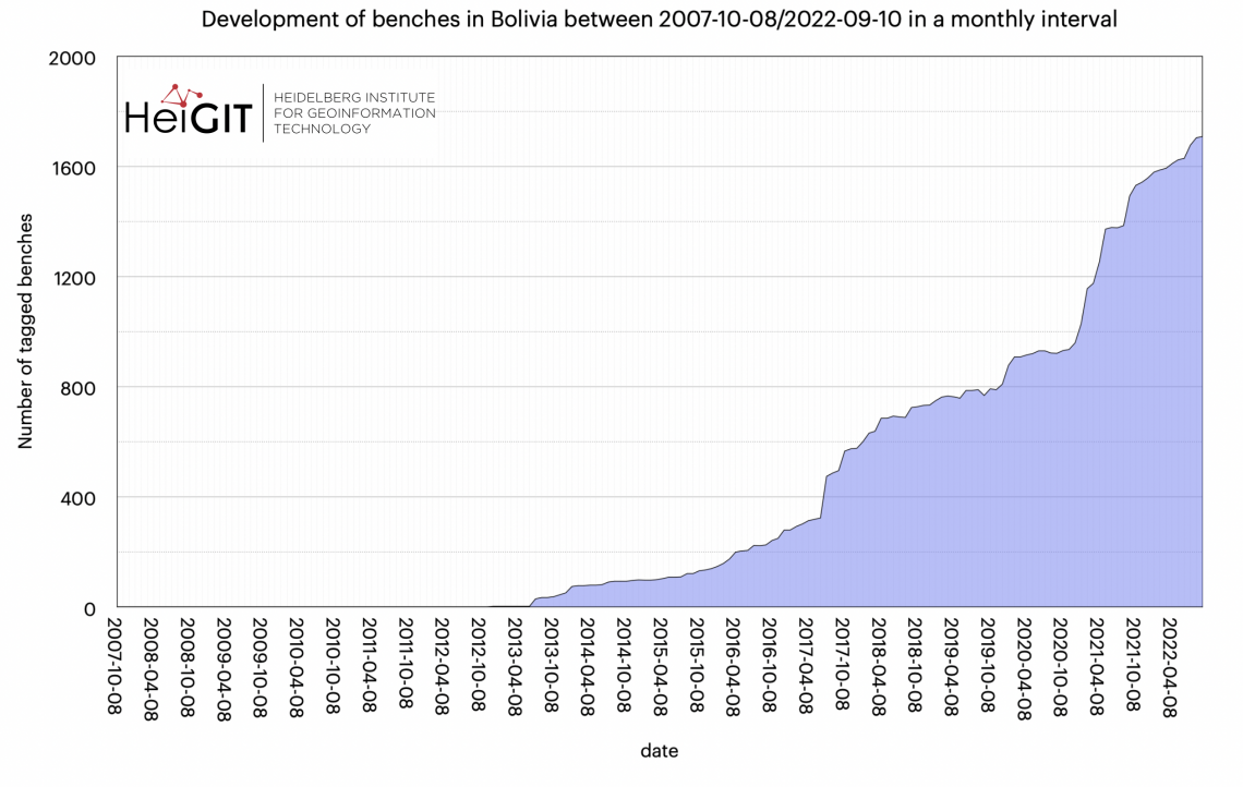
As you can see in the figure above, there were zero benches tagged in Bolivia until December 2012. This could be due to these kinds of objects not being a top priority when it comes to mapping infrastructure. Still, benches help paint a fuller picture of the real world as long as the objects are marked with a high degree of accuracy to ensure data quality. The main increases in bench tagging numbers were during summer 2017 and after late 2020. The latter trend could be due to several factors, including the pandemic.
Although the overall values for bench tagging in Bolivia may not be incredibly high, they too helped our community to achieve the 10th billionth object. Even small contributions can help make OpenStreetMap a very rich source of free, (ideally) accurate and current geospatial information.
This example illustrates how ohsome API and the OpenStreetMap itself can help visualize the development of local knowledge throughout the years as the community grows and external events allow contributors to increase available data and data quality.
Thank you for joining us on this journey and taking the time to read about our “ohsome” news! Stay tuned as there’s always more news coming!
Background info: the aim of the ohsome OpenStreetMap History Data Analytics Platform is to make OpenStreetMap’s full-history data more easily accessible for various kinds of OSM data analytics tasks, such as data quality analysis, on a regional, country-wide, or global scale. The ohsome API is one of its components, providing free and easy access to some of the functionalities of the ohsome platform via HTTP requests. Some intro can be found here:
- ohsome general idea
- ohsome general architecture
- OSM element vectorisation