
Search results for: “climate change”
-
Call for Papers: Workshop on Geocomputational Analysis of Socio-Economic Data
Published: 30. June 2023 Figure from ACM SIGSPATIAL You have published an original research contribution on Geocomputational Analysis of Socio-Economic Data, or have a work-in-progress paper that would fit the topic?We invite you to contribute to the workshop on Geocomputational Analysis of Socio-Economic Data at the International Conference on Advances in Geographic Information Systems in…
-
Mosquito App Alert
Prof. Dr. Alexander Zipf and Charlie Hatfield from HeiGIT contribute with their expertise on participatory science to an interdisciplinary case study by IDAlert on the monitoring of invasive mosquito populations in Heidelberg and the Rhine-Neckar-Region. One part of the case study is the Mosquito Alert App that recently has been launched in Germany and draws…
-
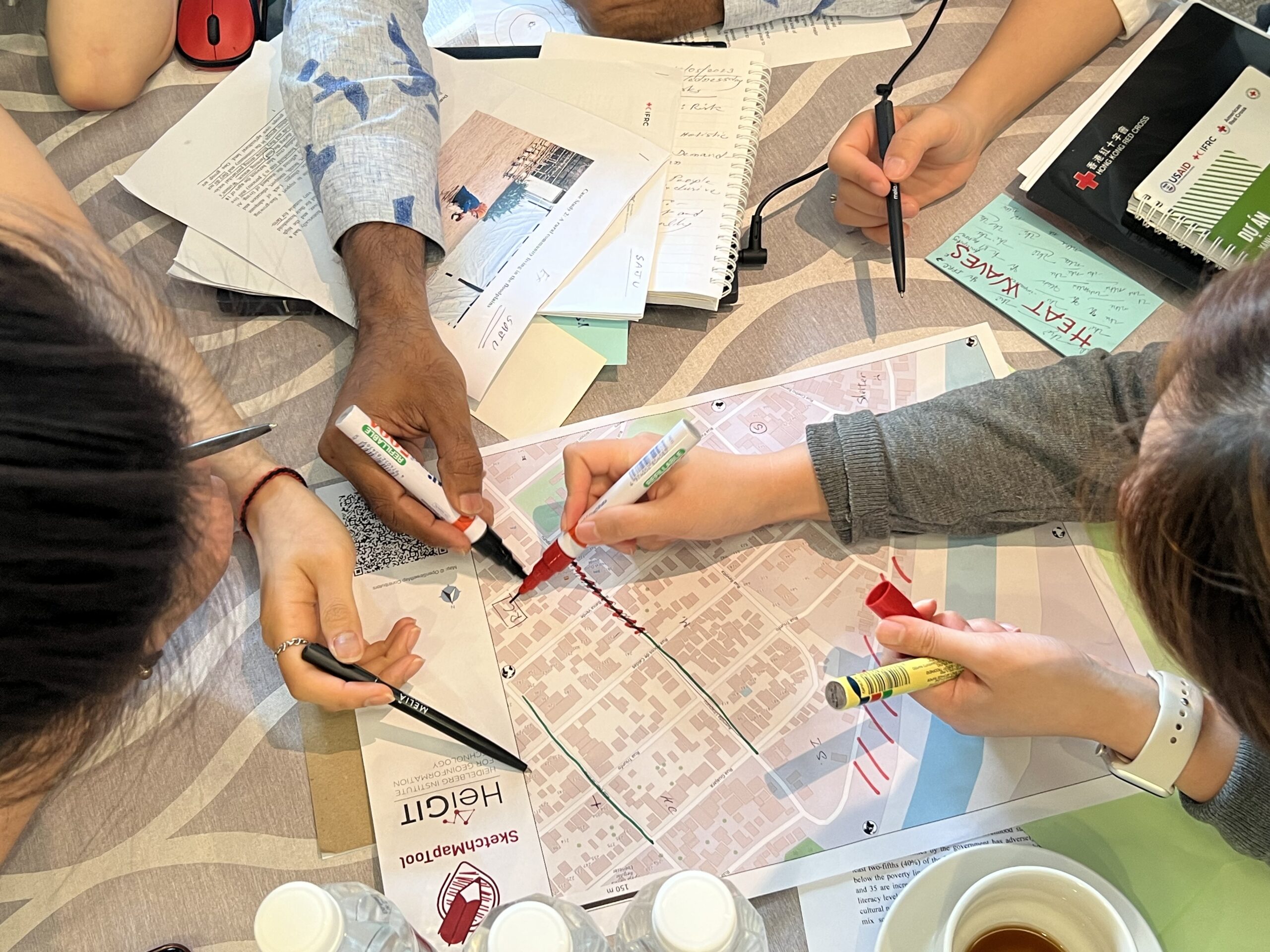
Training on digitalization of participatory mapping in Kuala Lumpur
Featured Image: Training participants simulating a participatory mapping on the ground with the SketchMapTool. Last week, HeiGIT team member Anne Schauß held a workshop session in Kuala Lumpur, Malaysia, during a training of the International Federation of Red Cross and Red Crescent Societies (IFRC). The international training focused on community resilience and how to assess…
-
CharAct4D – Unravelling Landscape Dynamics via Automatic Characterization of Surface Activity using Geographic 4D Monitoring
With her new project CharAct4D Dr. Katharina Anders has become part of the Eliteprogramme for Postdocs of the Baden-Württemberg Stiftung, which supports early career researchers to qualify for a professorship -check the related press release by Heidelberg University. Many congratulations, Katharina! Katharina’s research interests in the 3DGeo research group are method development for 3D/4D change analysis…
-
Open Data: Multi-platform point clouds and orthophotos of the inland dune in Sandhausen
The commune Sandhausen (Baden-Württemberg) got its name from the inland dune, which is located in the area of the village. In 2021 and 2022, the 3DGeo group of Heidelberg University conducted UAV-based and ground-based surveys of three areas of the inland dune of Sandhausen to acquire 3D point clouds and orthophotos. The dataset is freely and…
-
UndercoverEisAgenten auf Social-Media
Permafrost ist gefrorener Boden und in der Arktis weit verbreitet. Gebäude und Straßen werden auf ihm gebaut. Doch was passiert, wenn diese Böden durch die Klimaerwärmung zunehmend auftauen? Zusammen mit jungen Bürgerwissenschaftler*innen in der kanadischen Arktis und Deutschland gehen wir auf Spurensuche! Wir freuen uns sehr über den Start unserer Social-Media-Kanäle! Erfahrt mehr über das…
-
Job Opportunity: International Public Relations Manager; Science Communication & International Outreach at HeiGIT, Heidelberg
Job advertisement HeiGIT gGmbH You want to work for the benefit of society and the environment? HeiGIT wants to improve the availability and quality of geospatial data and further develop geoinformation technologies used for open, non-profit applications in the field of sustainability, mobility and humanitarian aid. Help us to reach these goals with your know-how…
-
Job Offer: Senior Science Manager — Innovation & Research Manager GIScience (m, f, d), 100%, permanent
Du willst Deine Management- und Forschungsexpertise zum Wohle der Gesellschaft und Umwelt einsetzen? Du willst HeiGIT dabei unterstützen die Verfügbarkeit und Qualität von Geodaten zu verbessern und Geoinformatik-Methoden weiterzuentwickeln, die für offene, gemeinnützige Anwendungen im Bereich Nachhaltigkeit, Mobilität und humanitäre Hilfe eingesetzt werden? Das ist unsere Mission! Die HeiGIT gGmbH ist ein forschungsorientiertes, gemeinnütziges Start-up…
-
Job Offer: “Lead: Geo Machine Learning for Good” Senior Spatial Data Science Expert (m, f, d) 100% permanent, HeiGIT gGmbH
Job advertisement HeiGIT gGmbH Do you want to use your machine learning expertise for the benefit of society and the environment? Do you want to improve the availability and quality of geospatial data and further develop geoinformatics methods used for open, non-profit applications in the field of sustainability, mobility and humanitarian aid? That’s our mission…
-
We are Hiring! Several new GIScience Jobs in sight in Heidelberg at HeiGIT
You are interested in contributing to research and development to support decision making in the field of sustainability, mobility and humanitarian aid? You want to achieve a better society and environment by improving open geoinformation and geoinformation technology? Help us to accomplish this through open geoinformation, open methods, open software and close collaboration with our…
-
Job Offer: “Lead: Geo Machine Learning for Good”, Senior Spatial Data Science Expert (m, f, d), 100%, permanent, HeiGIT gGmbH
Du willst Deine Machine Learning Kompetenz zum Wohle der Gesellschaft und Umwelt einsetzen? Du willst die Verfügbarkeit und Qualität von Geodaten verbessern und geoinformatische Methoden weiterentwickeln, die für offene, gemeinnützige Anwendungen im Bereich Nachhaltigkeit, Mobilität und humanitäre Hilfe eingesetzt werden? Das ist auch unsere Mission! Die HeiGIT gGmbH ist ein forschungsorientiertes, gemeinnütziges Start-up mit den…
-
New Project: GeCO: Generating high-resolution CO2 maps by Machine Learning-based geodata fusion and atmospheric transport modelling
Recently a new project has been starting in the context of Climate Change Action research: GeCO: Generating high-resolution CO2 maps by Machine Learning-based geodata fusion and atmospheric transport modelling The spatiotemporal distribution of greenhouse gases and their sources on Earth has so far been considered mainly at relatively coarse resolutions. There is a lack of…