

With her new project CharAct4D Dr. Katharina Anders has become part of the Eliteprogramme for Postdocs of the Baden-Württemberg Stiftung, which supports early career researchers to qualify for a professorship -check the related press release by Heidelberg University. Many congratulations, Katharina!
Katharina’s research interests in the 3DGeo research group are method development for 3D/4D change analysis and geographic analysis of multitemporal 3D point clouds and LiDAR time series for understanding the spatial and temporal dimensions of landscape dynamics.
About the project
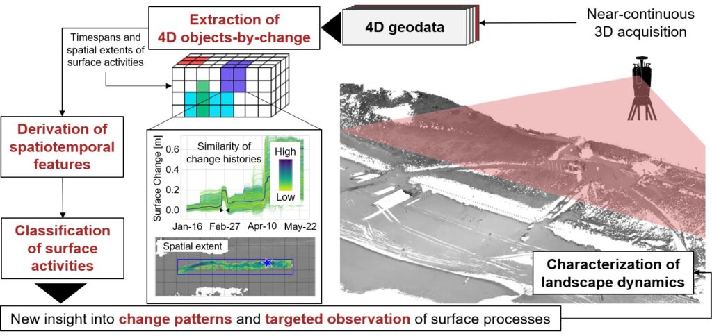
The objective of this project is to fundamentally improve the characterization of landscape dynamics using novel computer-based methods of change analysis in combination with recent strategies of geographic 3D monitoring. Landscape surfaces of our Earth are highly complex in their dynamics, because processes occur on a large range of spatiotemporal scales. From high-mountain glaciers to sandy coasts, surface activity within a local landscape occurs at different magnitudes, spatial extents, velocities, and return frequencies. Capturing and characterizing surface dynamics within a landscape – both naturally or human-induced – is key to increasing our understanding of underlying environmental processes and their complex interplay with human actions. Extending our knowledge in this respect is of high societal relevance, as it contributes to improved mitigation of climate change consequences where the effect of measures can be better observed and anticipated. This regards, for example, the effectiveness of measures against erosion of coasts or of soil in agricultural use.
The project will address the following central objectives:
- Providing an automatic and flexible method of 4D change analysis for different kinds of input data and surface activities by extending recent methods of change analysis for 4D point clouds
- Deriving new information layers from spatiotemporal properties of surface activities for interpretation by analysts, for supporting decision making (e.g., to adapt the observation settings), and for further characterization of underlying surface processes in subsequent analysis
- Enabling automatic classification of surface activities based on spatiotemporal features as characteristic change descriptors using unsupervised and supervised methods
Stay tuned and follow project updates on Twitter and LinkedIn via #CharAct4D
Related publication
Hulskemper, D., Anders, K., Antolínez, J.A.Á., Kuschnerus, M., Höfle, B., Lindenbergh, R. (2022): Characterization of Morphological Surface Activities derived from Near-Continuous Terrestrial LiDAR Time Series. The International Archives of the Photogrammetry, Remote Sensing and Spatial Information Sciences, XLVIII-2/W2-2022, 53-60. DOI: 10.5194/isprs-archives-XLVIII-2-W2-2022-53-2022.
Related projects
- 4D Objects-By-Change: Change Analysis of Natural Surfaces using 3D Time Series
- py4dgeo: library for change analysis in 4D point clouds
Funding
We are indebted to the Baden-Württemberg Stiftung for the financial support of this research project (duration 2023-2026) by the Eliteprogramme for Postdocs.