Land use decision involve trade-off with respect to the ecosystem service produced by the different land use systems. Agricultural use versus natural ecosystems is the main alternative for which trade-offs need to be estimated. Given the varying climatic and soil conditions this trade-off differs in space. Therefore, it is essential how agricultural land use is allocated. In addition, it is important which crop type is used since the different crops have different demands and produce different amount of services. While existing scenario analysis compares differences between different plausible future developments this is not sufficient to quantify trade-offs of land use. Better land use allocations might exist than the few considered scenarios. For a proper quantification of trade-offs it is therefore essential to estimate and analyze the best alternatives. The concept of Pareto-optimality is used for this purpose: the Pareto frontier describes the solutions (in our case land use allocations) there one cannot improve in one objective without losing something in another objective.
HeiGIT member Sven Lautenbach presented results of a collaboration with KIT IMK-IFU (Anita Bayer and Almut Arneth) at the German Jahrestagung der Gesellschaft für Informatik in Karlsruhe at the workshop “Künstliche Intelligenz in der Umweltinformatik” (Artifical Intelligence in environmental informatics).
The analysis took place at the global scale at a 1° by 1° grid cell resolution. Carbon storage, food provisioning by crops and water supply their used as objectives. The current among of fodder production by pasture was used as a constraint in the optimization. While it is obvious that a vegan food system would led to a favorable situation the analysis assumed this would be highly unlikely to be a reasonable alternative.
The dynamic ecosystem model LPJ-GUESS was used to quantify the three objectives and the constraint for potential natural vegetation and four crop functional types in a rainfeed and an irrigated alternative -leading to 9 alternatives for each grid cell. The multi-objective genetic algorithm NSGA-II was used to estimate the Pareto-frontier. Protected areas and climatic and topographic limits for the different crop functional types there imposed on the optimization problem. Optimization further used the objectives of the current land use under the scenario conditions as a constraint in the optimization, penalizing solutions by the number of constraints violated and the magnitude of the violation. The optimization was performed for a mid term (2033-2042) and a long term (2090-2099) planning horizon and for two representative concentration pathways (RCP 2.6 and RCP 6.0).
Results indicate a remarkable potential to increase in all three objectives simultaneously – however, at the cost of significant land use reallocation. The frontiers for the end of century planning horizon show an even bigger potential, indicating that current land use allocation is not well suited for changing climatic conditions. Analysis of land use allocations across the frontier indicate for example that large areas of the tropical and boreal forests should be excluded from agricultural land use.

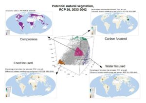
- Analysis of the Pareto frontier for RCP 2.6, 2033-2042 with respect to the number of solutions that placed potential natural vegetation at a specific cell. The map to the upper left shows the percentage of solutions across the part of the frontier that represents a compromise between the 3 objectives had allocated PNV at a specific cell. The other 3 maps show the difference of extreme solutions – that focused on a specific objective – to the compromise solutions. Green colors indicate that more PNV was allocated in solutions in the extrem solutions than for the compromise solutions. Brown colors indicate the opposite.


