

Tag: Land Use
-
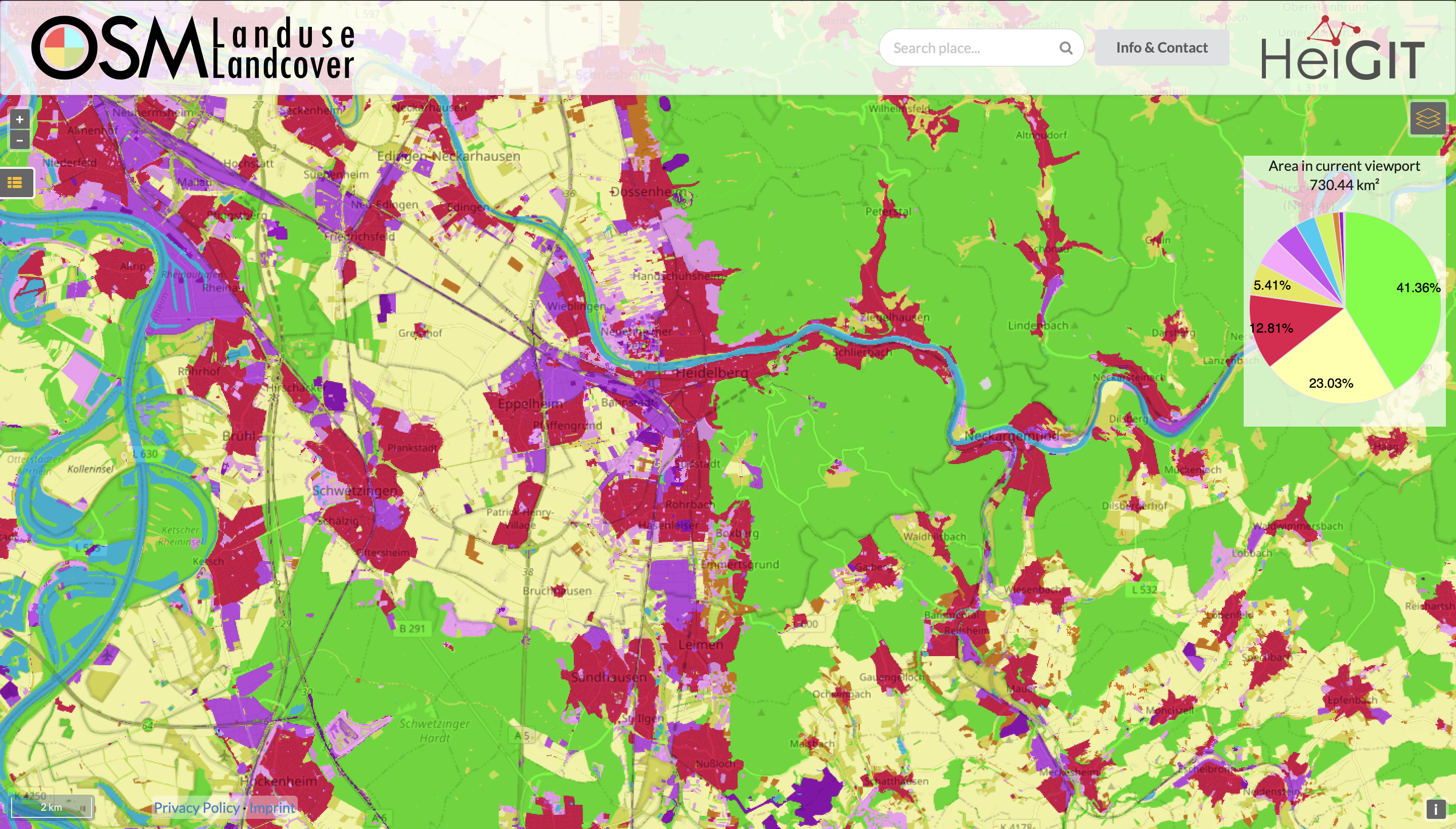
Functionality Update for OSM Landuse Landcover
We are pleased to announce that https://osmlanduse.org has received a functionality update. Thanks to the cooperation of GIScience and HeiGIT under the IDEAL-VGI project, our researchers were able to add a number of new features to the interactive map. The map displays OSM land-use and land-cover information. The two different data layers that made up…
-
Mapping Public Urban Green Spaces Based on OpenStreetMap and Sentinel-2 Imagery Using Belief Functions
Public urban green spaces are important for the urban quality of life. Still, comprehensive open data sets on urban green spaces are not available for most cities. As open and globally available data sets, the potential of Sentinel-2 satellite imagery and OpenStreetMap (OSM) data for urban green space mapping is high but limited due to…
-
Estimating trade-offs of land use at global scale
Land use decision involve trade-off with respect to the ecosystem service produced by the different land use systems. Agricultural use versus natural ecosystems is the main alternative for which trade-offs need to be estimated. Given the varying climatic and soil conditions this trade-off differs in space. Therefore, it is essential how agricultural land use is…
-
meinGrün @roadto_festival: What OSM tells us about urban green space features
Where is the next shaded bench to escape the burning heat? Where can I play soccer within the city and later on have a barbecue with my friends? All of these questions require information about features of urban green spaces. Although it is easy to find the right place within your own neighbourhood, it is…
-
Constraints in multi-objective optimization of land use allocation – Repair or penalize?
Land is a spare resource so it makes sense to think about how to use it most efficiently. This leads to the problem of land use allocation under consideration of trade-offs. Multi-objective optimization algorithms are a tool quantify the trade-offs by estimating the Pareto-optimal land use allocations. Often, constraints in the solution space have to…
-
GIScience/HeiGIT and TdLab Geographie at german IPCC conference
GIScience will be present with two participants (Nicole Aeschbach, TdLab Geographie) and Sven Lautenbach (HeiGIT) at the german IPCC conference. Our contributions aim at highlighting the potential of GIScience and transdisciplinary research for climate change adaptation and climate change mitigation. Examples are the german climate protection map, green or pleasant routing (e.g. meinGrün ) and…
-
GIScience/HeiGIT at Global Land Project open science meeting
GIScience/HeiGIT member Sven Lautenbach is hosting together with Jonas Schwaab from the ETH Zürich a session on Multi-objective optimization approaches to support visioning and decision-making in land-use system science at the 4th Open Science Meeting of the Global Land Programme April 24-26, 2019 | Bern, Switzerland. The session aims at approaches that study the potential…
-
Use of multi-objective optimization to assess trade-offs of urban expansion in Switzerland
One of the many unwanted side effects of urban growth is the loss of fertile soils since most citizens and villages have been founded in close proximity to fertile soils. Preserving high-quality soils however can conflict with the objective of developing compact urban patterns. A team from researches at the GIScience group, the ETH Zürich…
-
This Monday HCE Talk on: Ökologische Dienstleistungen und Zielkonflikte von Landnutzungsentscheidungen (Dr. Lautenbach)
As a founding member of Heidelberg Center for the Environment (HCE) we want to share this important date of the HCE’s “Heidelberg Bridge” Colloquium series. This semester the Institute of Geography is involved with two presentations and one of these is from the GIScience group with Dr. Sven Lautenbach talking about his work on ecosystem…
-
LandSense Stakeholder workshop 25.-26.01.2017
During last weeks LandSense stakeholder at IIASA workshops various tools relevant for VGI data capture, Quality assessment and beyond were discussed. Potential hotshots for validation and improvement of OSMLanduse were FotoQuest and LacoWiki. Also discussed were platforms for hobby bird fans or for spatial data geeks. http://www.geog.uni-heidelberg.de/gis/land_sense.html http://osmlanduse.org
-
Mapping of environmental risk factors in everyday life
Psychiatric research is increasingly interested in the influence of social and environmental contexts on human health. According to recent findings, specific impacts of urban upbringing on neural social stress processing relate to the heightened prevalence of mental disorders in cities. Although this is a major societal problem, it remains unknown which environmental components (e.g., psychosocial…