

Category: Land use
-
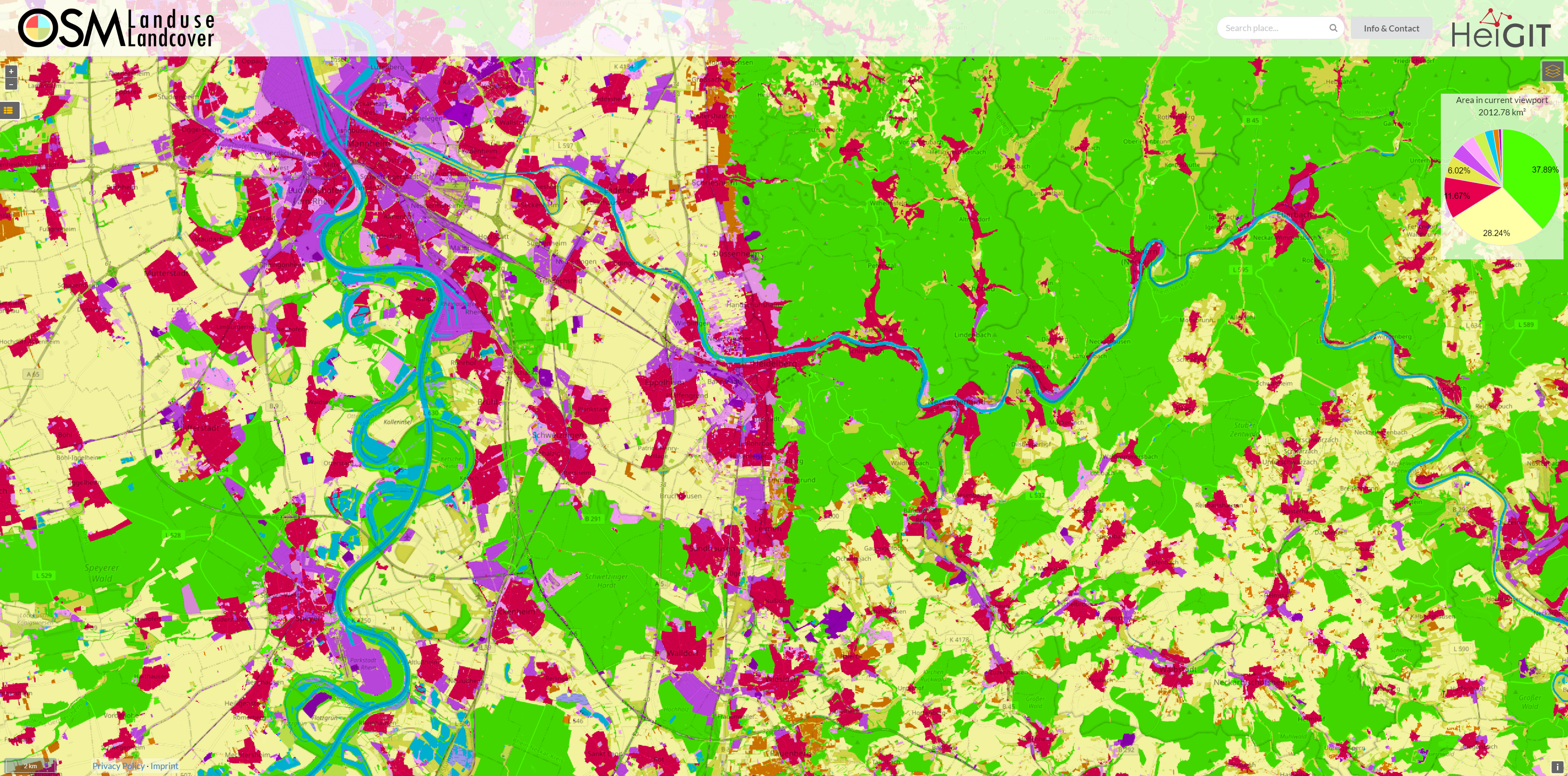
OSM Landuse Data is available in HeiData
We are excited to announce that the data displayed on OSM – Landuse is now freely accessible. These data sets offer valuable insights and can be utilized for various applications. Urban planners will find the data useful for development projects and zoning regulations, while environmental researchers can study land use changes and their impact on…
-
Unveiling the Impact of School Commutes: Charles Hatfield Presents Insights on Traffic Congestion and Urban Planning at ATRC 2024
Charles Hatfield will represent HeiGIT at the first ever African Transport Research Conference (ATRC 2024) which takes place from March 5-7 in Capetown, South Afrika. The conference was established to address rapid urbanisation in Africa and the corresponding challenges for transport and infrastructure. Volvo Research and Educational Foundations (VREF) and the Centre for Transport Studies…
-
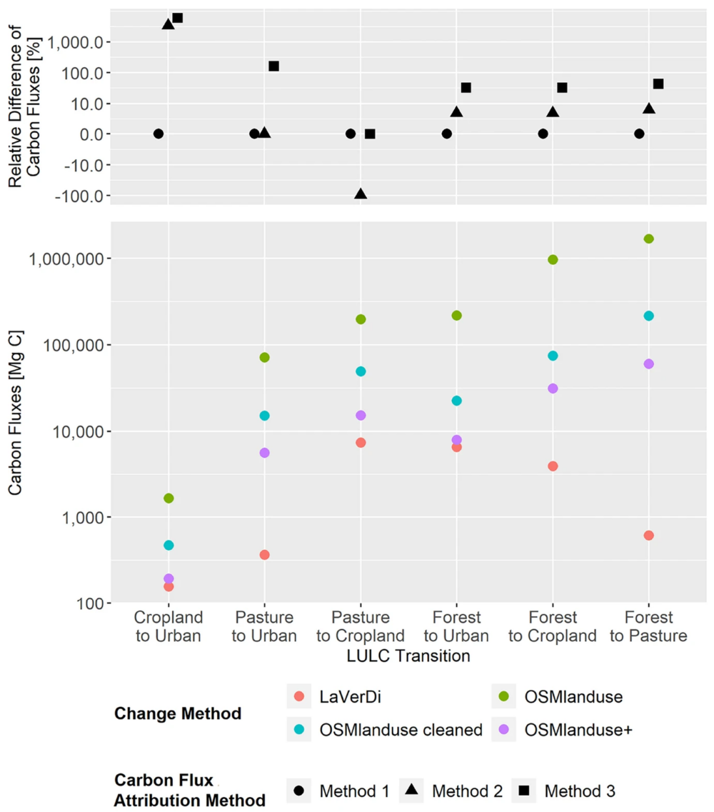
New Paper: Carbon Fluxes Related to Land Use and Land Cover Change in Baden-Württemberg
Featured Image: Figure 1. Total carbon fluxes related to LULCC in Baden-Württemberg between March 2018 and October 2019 (LaVerDi, OSMlanduse+), and March 2018 and March 2020 (OSMlanduse, OSMlanduse cleaned). The upper plot shows the relative difference of carbon fluxes [%] with respect to LULC transition and carbon flux attribution method. The carbon fluxes of method…
-
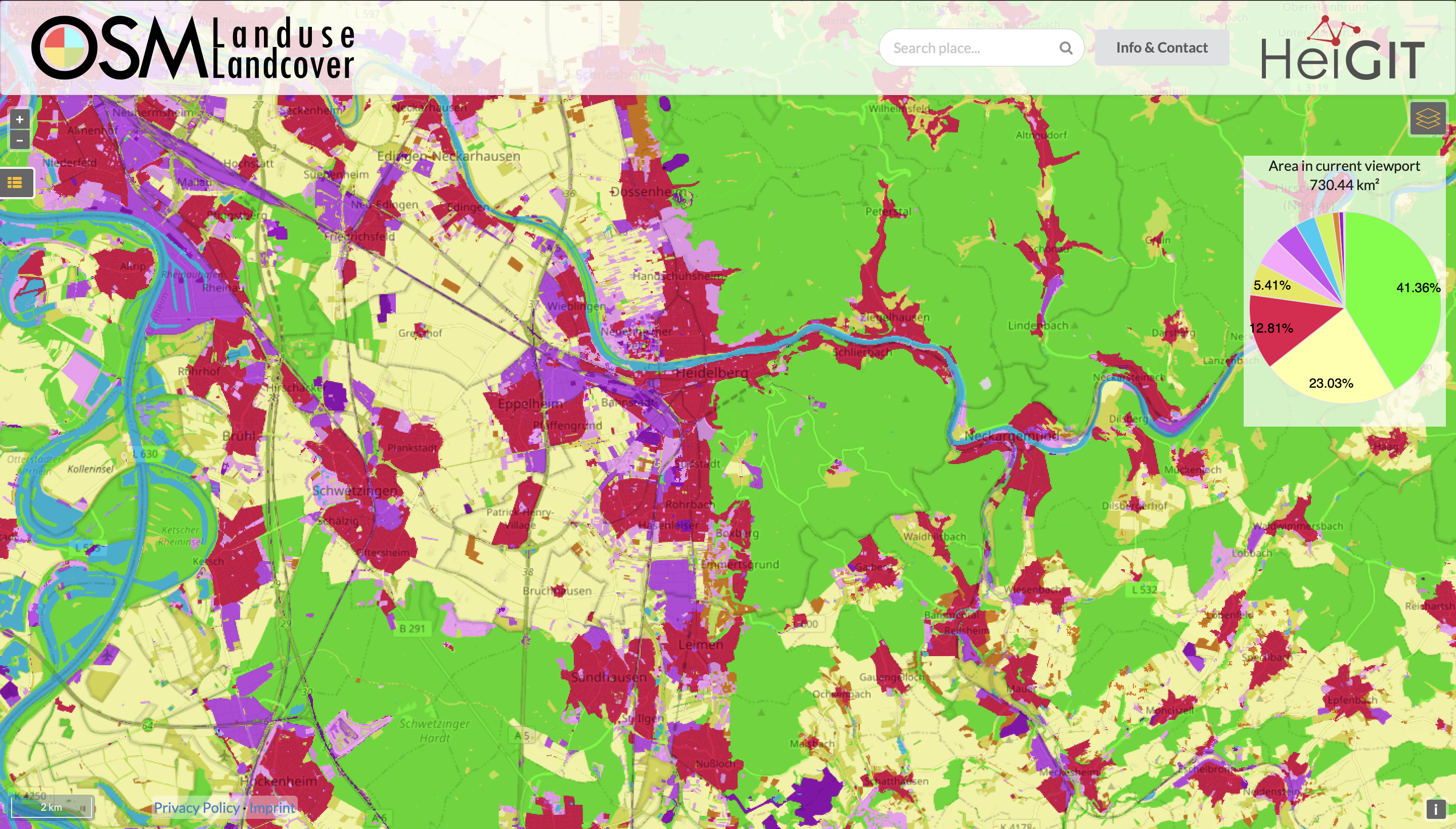
Functionality Update for OSM Landuse Landcover
We are pleased to announce that https://osmlanduse.org has received a functionality update. Thanks to the cooperation of GIScience and HeiGIT under the IDEAL-VGI project, our researchers were able to add a number of new features to the interactive map. The map displays OSM land-use and land-cover information. The two different data layers that made up…
-
Open GIScience PostDoc positions on understanding the relationships between “Urban nature experience, biodiversity and mental health”
We call for applications to postdoctoral positions within the Heidelberg Mannheim Health and Life Science Alliance “Innovation Campus” for Inter-institutional project. The Central Institute of Mental Health (ZI), Prof. A. Meyer-Lindenberg, the GIScience Research Group at Heidelberg University (Prof. A. Zipf), the 3DGeo Group (Prof. B. Höfle); and the Department of Biodiversity and Plant Systematics…
-
Leveraging OpenStreetMap and Multimodal Remote Sensing Data with Joint Deep Learning for Wastewater Treatment Plants Detection
Humans rely on clean water for their health, well-being, and various socio-economic activities. During the past few years, the COVID-19 pandemic has been a constant reminder of about the importance of hygiene and sanitation for public health. The most common approach to securing clean water supplies for this purpose is via wastewater treatment. To date,…
-
Automatic mapping of national surface water with OpenStreetMap and Sentinel-2 MSI data using deep learning
Large-scale mapping activities can benefit from the vastly increasing availability of earth observation (EO) data, especially when combined with volunteered geographical information (VGI) using machine learning (ML). High-resolution maps of inland surface water bodies are important for water supply and natural disaster mitigation as well as for monitoring, managing, and preserving landscapes and ecosystems. In…
-
Mapping Public Urban Green Spaces Based on OpenStreetMap and Sentinel-2 Imagery Using Belief Functions
Public urban green spaces are important for the urban quality of life. Still, comprehensive open data sets on urban green spaces are not available for most cities. As open and globally available data sets, the potential of Sentinel-2 satellite imagery and OpenStreetMap (OSM) data for urban green space mapping is high but limited due to…
-
LandSense Horizon 2020 A Citizen Observatory and Innovation Marketplace for Land Use and Land Cover Monitoring, project successful finished
The Horizon 2020 LandSense project was concluded successful. Please find a selection of the produced publications and deliverables here. The project has enabled our group to pursue quality aspects of voluntarily collected geo information data and to ramp up efforts related to OSMlanduse. Together with the University of Nottingham (Giles Foody) and Institut national de l’information…
-
OSMlanduse European Union validation effort EuroSDR conference 11/24/2020
During the EuroSDR workshop we will present our OSMlanduse product (earlier post) to the land use (LU) and land cover community (LC) and highlight class accuracies and a benchmark comparison towards existing national authoritative products. Accuracy estimated to be presented are based on more than 7k reference points collected in the past month through a…
-
Regional Variations of Context-based Association Rules in OpenStreetMap
As a user‐generated map of the whole world, OpenStreetMap (OSM) provides valuable information about the natural and built environment. However, the spatial heterogeneity of the data due to cultural differences and the spatially varying mapping process makes the extraction of reliable information difficult. A newly published study investigates the variability of association rules extracted from…
-
OSMlanduse wird auf Geonet.MRN Meetup zu Flächennutzung und Flächenmanagement vorgestellt: Donnerstag 29.10.2020, 16:30
Am am 29.10.20, 16:30 Uhr veranstaltet das Netzwerk Geoinformation der Metropolregion Rhein-Neckar GeoNet.MRN zum Thema: Flächennutzung und Flächenmanagement: Ein Geoinformation Meetup Teilnahme: Kostenlos und ohne Anmeldung mit Teams unter diesem Link. Themen des Meetups sind die Online-Beteiligung von Kommunen, Bürgern sowie Firmen und Institutionen im Bereich Flächenmanagement mit Fokus auf die Siedlungs- und Verkehrsentwicklung und die…