

In order to analyze the quality of OSM data, a study at GIScience Heidelberg investigated the influence of the mappers’ cultural backgrounds on their mapping behavior and hence questioned the general validity of semantic (street) classifications in OSM.
Nepal was hit by a series of earthquakes in April 2015. The OSM community quickly reacted by organizing mapping events all over the world to provide current information on affected areas, destroyed cities, accessible roads, and – in consequence – people in need of aid.
Taking this data and using an approach measuring the _change_ of road classification, the semantic attribution and their temporal changes were inspected at Heidelberg University (Eckle et al. 2015). The analysis revealed rather significant inconsistencies in the lower road classes, with many objects switching categories multiple times. The results suggested a rather strong influence of the individual mapper’s opinion, resulting in a rather heterogeneous dataset.
Based on these first insights, a follow-up study investigates the factors determining such individual differences, starting with the linguistic and cultural dimension. Even though OSM provided a Humanitarian OpenStreetMap Team (HOT) task describing the procedure to be followed when mapping roads in Nepal, the results still varied significantly. The task was provided in English, leaving the question whether the interpretation of the English task text could potentially vary between groups of different linguistic and/or cultural background. The results confirm, that the process of interpreting mapping instructions is influenced by the individual experience, coloring the results with the individual’s background. This background can be grouped using nationality as a uniting factor. Mappers of different nationalities often interpret mapping instructions differently, causing varying results between different nationalities. The cause of these differences lies in the different experience background. Streets and street classifications, and especially the boundaries of the individual street classes, vary between different countries. These differences can be defined as linguistically shaped. While streets and their size, usability and purpose naturally present a continuum, they become discreet only after applying a linguistic classification. These classification systems reciprocally shape reality, deepening the distinction of individual classes, i.e. classifying streets a certain way leads to administrative specifications, such as speed limits, road limits, jurisdictions, etc. Reciprocally, these specifications further increase the differences between the individual classes.
As mappers of different cultural-linguistic backgrounds did indeed map very differently, the Linguistic Relativity Hypothesis was confirmed. The cultural-linguistic background seems to have an impact on the perception and assessment of a visual input, in this case the satellite imagery. For the purpose of this study, the perceived living environment was defined as the linguistically influenced surrounding of individuals. Language in this scenario takes on a reciprocally influencing role – i.e., the linguistic description of reality in turn shapes reality.
Projects utilizing volunteered geographic information that includes the individual to add classification elements (as opposed to merely submitting GPS data) need to recognize the cultural-linguistic element and interpret the data accordingly.
We will report the detailed results in a future open access publication, soon. Stay tuned!
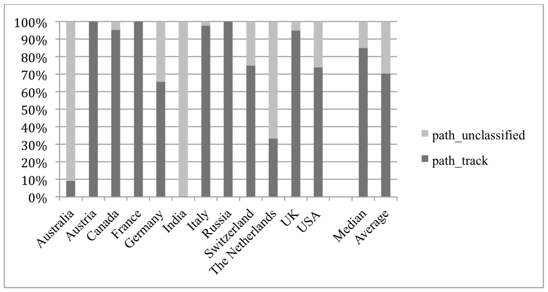
Figure (example): Changes in Classification among all Countries for the Source Class “Path” to path_track or path_unclassified
Related earlier work:
- Eckle, M., Albuquerque, J. P. (2015). Quality Assessment of Remote Mapping in OpenStreetMap for Disaster Management Purposes. ISCRAM 2015 – 12th International Conference on Information Systems for Crisis Response and Management. Kristiansand, Norway
- Auer, M.; Eckle, M.; Fendrich, S.; Griesbaum, L.; Kowatsch, F.; Marx, S.; Raifer, M.; Schott, M.; Troilo, R.; Zipf, A. (2018): Towards Using the Potential of OpenStreetMap History for Disaster Activation Monitoring. ISCRAM 2018. Rochester. NY. US.
- Mocnik, F.-B., Zipf, A., Raifer, M. (2017): The OpenStreetMap folksonomy and its evolution. Geo-spatial Information Science, GSIS. Taylor & Fancis. V 20, Issue 3. DOI: 10.1080/10095020.2017.1368193.
- Ballatore, A. and Zipf, A. (2015): A Conceptual Quality Framework for Volunteered Geographic Information. COSIT – CONFERENCE ON SPATIAL INFORMATION THEORY XII. October 12-16, 2015. Santa Fe, New Mexico, USA. Lecture Notes in Computer Science, pp. 1-20.