

Tag: classification
-
Deep learning with simulated laser scanning data for 3D point cloud classification
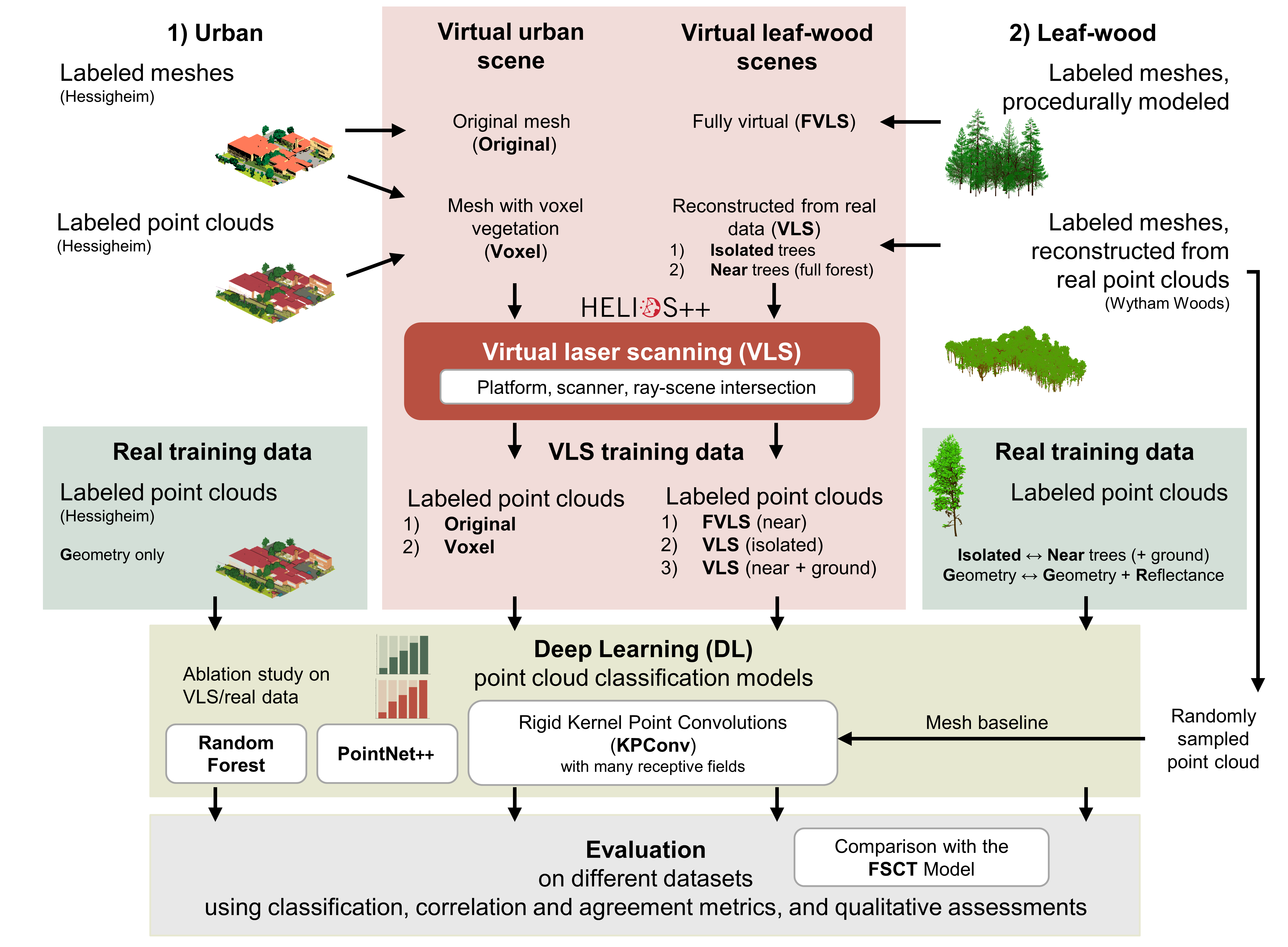
Esmorís, A.M., Weiser, H., Winiwarter, L., Cabaleiro, J.C. & Höfle, B. (2024): Deep learning with simulated laser scanning data for 3D point cloud classification. ISPRS Journal of Photogrammetry and Remote Sensing. Vol. 215, pp. 192-213. DOI: 10.1016/j.isprsjprs.2024.06.018 3D point clouds acquired by laser scanning are invaluable for the analysis of geographic phenomena. To extract information…
-
VirtuaLearn3D: New Preprint
We have published a preprint of our recent work in the VirtuaLearn3D project! Deep learning with simulated laser scanning data for 3D point cloud classification Esmorís, A.M., Weiser, H., Winiwarter, L., Cabaleiro, J.C. & Höfle, B. (2024) Laser scanning is an active remote sensing technique to acquire state-of-the-art spatial measurements in the form of 3D…
-
Introducing the VirtuaLearn3D Project
With VirtuaLearn3D (Virtual Laser Scanning for Machine Learning Algorithms in Geographic 3D Point Cloud Analysis), a new project of the 3DGeo group has started. The focus of this project is to enable powerful machine learning algorithms for geographic point cloud analysis by advancing the concept of virtual laser scanning to overcome the lack of training…
-
CharAct4D – Unravelling Landscape Dynamics via Automatic Characterization of Surface Activity using Geographic 4D Monitoring
With her new project CharAct4D Dr. Katharina Anders has become part of the Eliteprogramme for Postdocs of the Baden-Württemberg Stiftung, which supports early career researchers to qualify for a professorship -check the related press release by Heidelberg University. Many congratulations, Katharina! Katharina’s research interests in the 3DGeo research group are method development for 3D/4D change analysis…
-
Classification of 3D ALS Point Clouds using End-To-End Deep Learning
In a new publication, we show how deep neural networks can be used in an end-to-end manner for the classification of 3D point clouds from airborne laser scan data. The research, based on the award-winning diploma thesis of Lukas Winiwarter at TU Wien, has now been published in “PFG – Photogrammetrie, Fernerkundung, Geoinformation“, the Journal…
-
3DGeo at the Geospatial Week 2019
This week, the 3DGeo participated in the ISPRS Geospatial Week 2019 with two presentations among the sessions of the Laser Scanning Workshop with many interesting talks and poster. Presentations were given by Ashutosh Kumar in the Machine Learning Session and Katharina Anders in the Change Detection Session. Highlight: The work by Ashutosh Kumar on feature…
-
Paper on Analysis of Feature Relevance in Deep Learning for 3D Point Cloud Classification
A paper investigating the relevance of (pre-calculated) features for 3D point cloud classification using deep learning was just published in the ISPRS Annals of Photogrammetry and Remote Sensing. The study presents a non-end-to-end deep learning classifier for 3D point clouds using multiple sets of input features and compares it with an implementation of the state-of-the-art…
-
The influence of the OSM mappers’ cultural backgrounds on their mapping behavior
In order to analyze the quality of OSM data, a study at GIScience Heidelberg investigated the influence of the mappers’ cultural backgrounds on their mapping behavior and hence questioned the general validity of semantic (street) classifications in OSM. Nepal was hit by a series of earthquakes in April 2015. The OSM community quickly reacted by…
-
Context-Based Classification of Urban Blocks According to Their Built-up Structure
A recently published paper presents an approach for classifying urban blocks according to their built-up structure based on high-resolution spaceborne InSAR images. Most attributes considered in the classification describe the geometric structure and spatial disposition of the polygon and line features extracted from each block. The feature extraction is carried out on two intensity images…
-
Open land cover from OpenStreetMap and remote sensing
In a recently published study (1), we produced a web based land use land cover (LULC) product based on OSM tags which are constantly updated by contributors/volunteers, and present a Remote Sensing based solution when tags were absent for a test site. We harness the combined benefit of an open source and ever-growing machine generated…
-
Full-Waveform Airborne Laser Scanning in Vegetation Studies—A Review of Point Cloud and Waveform Features for Tree Species Classification
In recent years, small-footprint full-waveform airborne laser scanning has become readily available and established for vegetation studies in the fields of forestry, agriculture and urban studies. Independent of the field of application and the derived final product, each study uses features to classify a target object and to assess its characteristics (e.g., tree species). These…
-
Four contributions from GIScience Heidelberg at the ISPRS Congress in Prague
The LiDAR Research Group (LRG) of GIScience Heidelberg is contributing novel approaches for geological outcrop characterization, LiDAR simulation, tree classification as well as education in close-range sensing. You are kindly invited to visit our presentations at the ISPRS Congress 2016 in Prague. Furthermore our new HELIOS LiDAR Simulator will participate in the CATCON contest for…