

Tag: Mapping
-
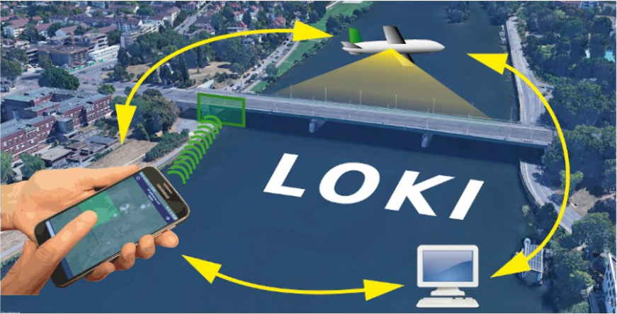
The LOKI Project: Rapid Earthquake Damage Assessment
In the aftermath of earthquakes, rapid and accurate assessment of infrastructure damage is crucial. The LOKI project (Airborne Observation of Critical Infrastructures), funded by the Federal Ministry for Education and Research and active from January 1, 2020, to March 31, 2023, aimed to tackle this challenge. Bringing together expertise from diverse research fields including earthquake…
-
Call for contributions!
Excited to announce the CALL FOR CONTRIBUTIONS! Are you passionate about mapping with communities? Join us at the “Mapping with communities: Contemporary approaches and challenges” workshop at AGILE 2024 conference on June 04. Share your experiences, methodologies, and digital innovations in engaging communities with geospatial data. Submit your extended abstract by May 20 to mappingwithcomm@glasgow.ac.uk.
-
GeoNight Mapathon on April 12th
Our next Mapathon is just around the corner, and this time, we’re joining forces with OpenStreetMap Ghana to improve coverage and to help disaster risk assessment.Join us and be a part of the GeoNight 2024 to celebrate geography together in all its forms and facets! Everyone is welcome and no previous knowledge is needed!Do bring your laptop and preferably…
-

Mapathon on February 7th
The first Mapathon this year will be on February 7th. When: Wednesday, 07.02.2024, at 7 p.m. Where: Berliner Straße 48, Hörsaal After a short introduction into the region and subject of this mapping task, you will also get instructions how to map. The Mapathon will be a collaboration with the German Red Cross (GRC) and…
-
Unleashing the Power of AI-Assisted Mapping in OpenStreetMap? – a webinar with HOT and Masaryk University
The ever-increasing volume and speed of corporate or machine learning-assisted mapping present unique challenges for individual volunteer mappers, particularly in terms of monitoring and validation. While the global impact and evolution of AI-assisted mapping in OpenStreetMap (OSM) remain largely unknown, there is a need to engage with mappers to understand their perspectives on this emerging…
-
MapSwipe is App of the Day in Apple AppStore
MapSwipe has ben announced as ‘App of the Day‘ in the Apple AppStore! (27.08.2021) Thank you to all our volunteers for the continued help and support which keeps the app going. Read the blogpost here: https://apps.apple.com/ca/story/id1559236909 The team at the Heidelberg Institute for Geoinformation Technology (HeiGIT) and the GIScience Research Group at Heidelberg University has shaped MapSwipe’s…
-
OSM completeness mapping for airborne situation assessment following an earthquake
As part of the LOKI project (Luftgestützte Observation Kritischer Infrastrukturen), a first test run of a newly launched OpenStreetMap (OSM) completeness mapping project in MapSwipe has been conducted yesterday. The aim of the LOKI project is to develop an interdisciplinary system that enables fast and reliable airborne situation assessments following an earthquake. The system will…
-
Exponat aus Heidelberg bietet Training für KI-Algorithmen auf der MS Wissenschaft
Mitmach-Exponate geben auf der MS Wissenschaft in Heidelberg vom 28. August bis 1. September Einblicke in die Entwicklung und Anwendung Künstlicher Intelligenz (KI). Mit auf dem zu einer schwimmenden Ausstellung umgebauten ehemalige Kohlefrachter ist auch ein Exponat des Heidelberg Institute for Geoinformation Technology (HeiGIT) an der Universität Heidelberg, gefördert von der Klaus Tschira Stiftung. Das…
-
HeiGIT supports Citizien Science @ Helmholtz ThinkCamp
We are always happy to support citizen science projects at the HeiGIT. HeiGIT/ GIScience efforts already range from tools that assess the data quality of citizen science projects (see, e.g., this blog post about “Plausible Parrots“) to approaches related to data creation, like MapSwipe Analytics (learn more here). Currently, we are supporting citizen science approaches…
-
The influence of the OSM mappers’ cultural backgrounds on their mapping behavior
In order to analyze the quality of OSM data, a study at GIScience Heidelberg investigated the influence of the mappers’ cultural backgrounds on their mapping behavior and hence questioned the general validity of semantic (street) classifications in OSM. Nepal was hit by a series of earthquakes in April 2015. The OSM community quickly reacted by…
-
OSM GeoWeek MissingMaps Mapping Event for Madagascar @Heidelberg
Dear Mapping Enthusiasts, Nov 13-19th is the international OpenStreetMap GeoWeek in context of the National Geographic’s Geography Awareness Week. In this scope the disastermappers/ GIScience Research Group Heidelberg invites you again to a special Mapathon to start the new semester. When: Thursday 17.11.2016, 6 pm Where: Hörsaal, Berliner Straße 48, Institute of Geography, Heidelberg University…
-
Castle accessibility mapping is part of a short documentary
Our efforts related to the mapping of the accessibility of places and ways at Heidelberg castle are now part of a short documentary produced by Beirat von Menschen mit Behinderung Heidelberg (Advisory Board of people with disabilities Heidelberg), with whom we cooperate in the scope of the CAP4ACCESS project. As a follow-up of this event,…