
Search results for: “humanitarian”
-
MapSwipe App for humanitarian mapping featured in Product Hunt today
today MapSwipe is featured in “Product Hunt”, a kind of reddit for products. https://www.producthunt.com/tech/mapswipe Learn more about the smartphone App that helps you to put a family on the map. It is so simple even children can use it but helps humanitarian organisations like the Red Cross and Doctors without Borders to better plan and…
-
Location matters – GIS in the humanitarian sector – Presentation by S. Sudhoff (CartONG)
On next monday, Sandra Sudhoff will give a public talk on the integration of GIS and other IT technologies with the humanitarian sector. Sandra is technical director at CartONG, a french NGO commited to providing geotools, geodata and professional guidance to decision makers and respondents in emergency relief and humanitarian aid. Like GIScience Heidelberg CartONG…
-
Urban Landuse, Flood Risks, VGI quality and GIS in humanitarian NGOs – save the date for GIScience presentations
Earlier this semester Dr. Chiao-Ling started the GIScience colloqium series already with a presentation about An Ontology-based Semantic Interoperability Framework for Geospatial Information. Now stay tuned and save the date for the further presentations in this semester: Deriving urban land use from image data – potentials, limitations and main approaches (Dr. Tessio Novack) Mo, 30.05.2016,…
-
Disaster Mappers Heidelberg organize Talk on Humanitarian Mapping Technologies by Patrick Meier
Thanks to the initative of the Disaster Mappers Heidelberg, Patrick Meier, co-founder of the StandbyTaskForce and the Harvard Humanitarian Initiative will give a presentation on February 11th 2015 via videoconference at the Insitute of Geography, Großer Hörsaal, Berliner Straße 48, Heidelberg at 4pm. Don’t miss this chance to learn more about Disaster Mapping, Crisis Mapping…
-

Waterproofing Data – Engaging Stakeholders in Sustainable Flood Risk Governance for Urban Resilience
Join us at Impact Day on May 15th in the foyer of the Neue Universität, organized by the Heidelberg University! The event will showcase the university’s knowledge and technology transfer, spotlighting projects across four focal areas: socially relevant, industrial, sustainable and tangible. The “Socially Relevant” island addresses pressing social issues, while the “Industrial” island highlights…
-

HeiGIT at the AGILE 2024 Conference: Mapping, Routing, Sustainability
“Geographic Information Science for a Sustainable Future” – The theme of this year’s conference held by the Association of Geographic Information Laboratories in Europe (AGILE) in Glasgow, UK, on 4-7 June 2024. Attendees of the AGILE 2024 conference will explore the crucial role of geographic information science (GIS) in the relationships between the environment, society,…
-
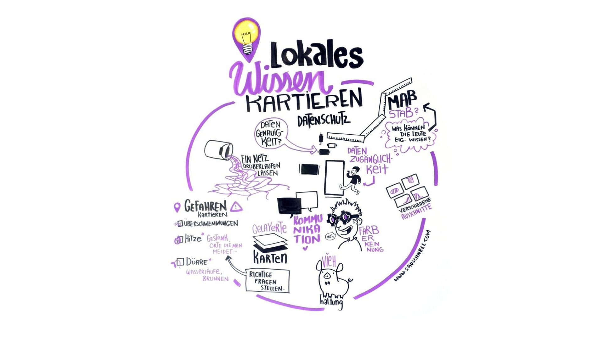
German Conference on Disaster Risk Reduction: Mapping Local Knowledge with the Sketch Map Tool
The 2024 Fachtagung Katastrophenvorsorge (Disaster Risk Reduction Symposium) centered around the theme “On the Edge? Disaster risk reduction in uncertain times.” Held in a hybrid format on April 22 and 23 at the Tagungswerk Berlin, this conference served as a platform to address the challenges, opportunities, and current developments in disaster prevention and management amidst…
-
Mapping Progress in Real Time: Highlights from GeoNight 2024 Mapathon with HeiGIT and Mannheimer Mapathons
During GeoNight 2024, HeiGIT partnered with Mannheimer Mapathons to host a mapathon together. Mapathons are events where volunteers come together to map crucial features like roads, buildings or waterways on OpenStreetMap, often in response to specific needs or crises, such as post-earthquake or post-flood scenarios. We were privileged to connect with volunteers from OSM Ghana, gaining insight into…
-
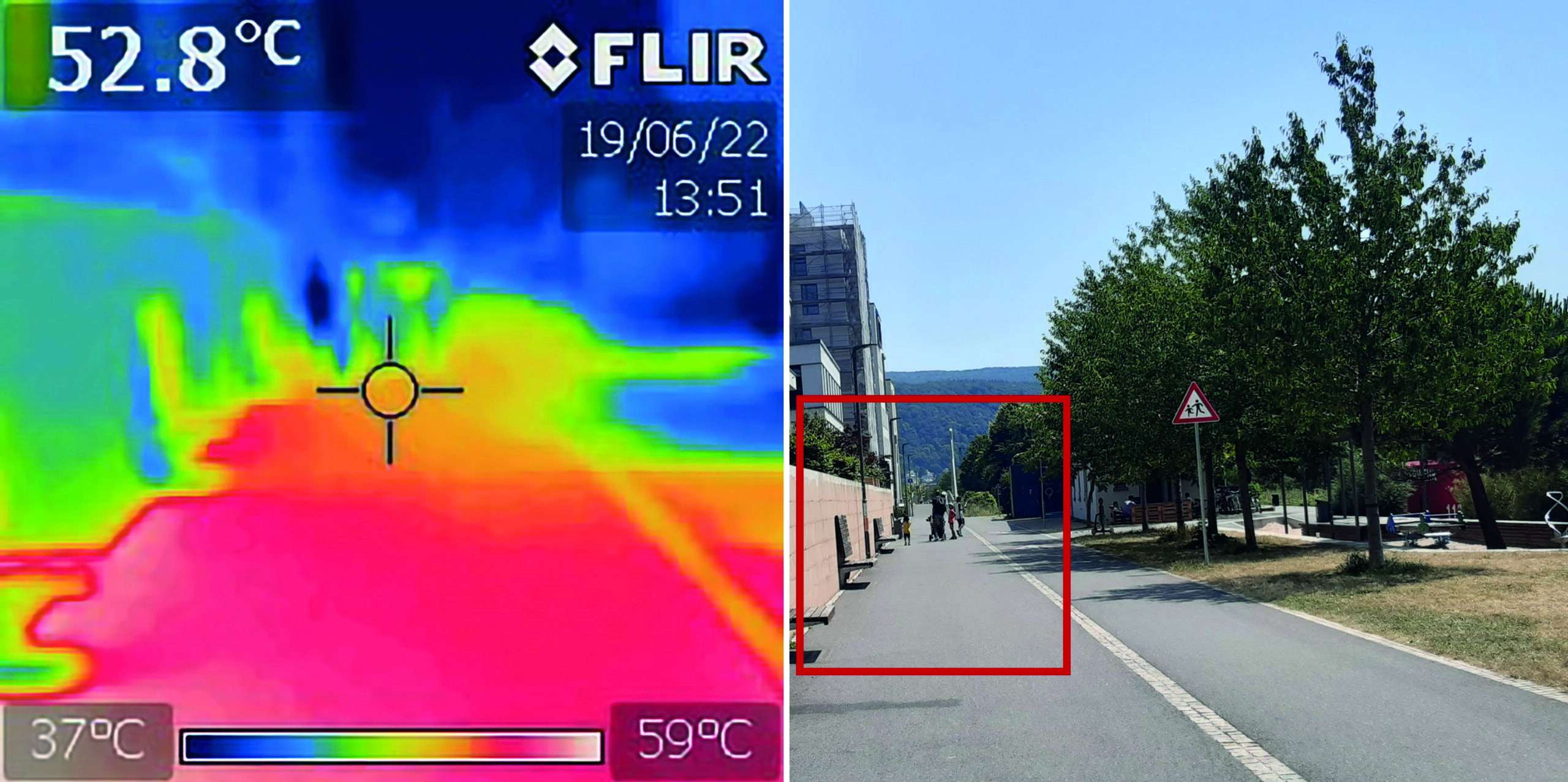
“How to assess the needs of vulnerable population groups towards heat-sensitive routing?”
The research team of the transdisciplinary project HEAL (Heat Adaptation for Vulnerable Population Groups), focusing on providing heat adaptation measures for vulnerable groups in Heidelberg, has published a research paper titled “How to assess the needs of vulnerable population groups towards heat-sensitive routing? An evidence-based and practical approach to reducing urban heat stress”. The paper…
-
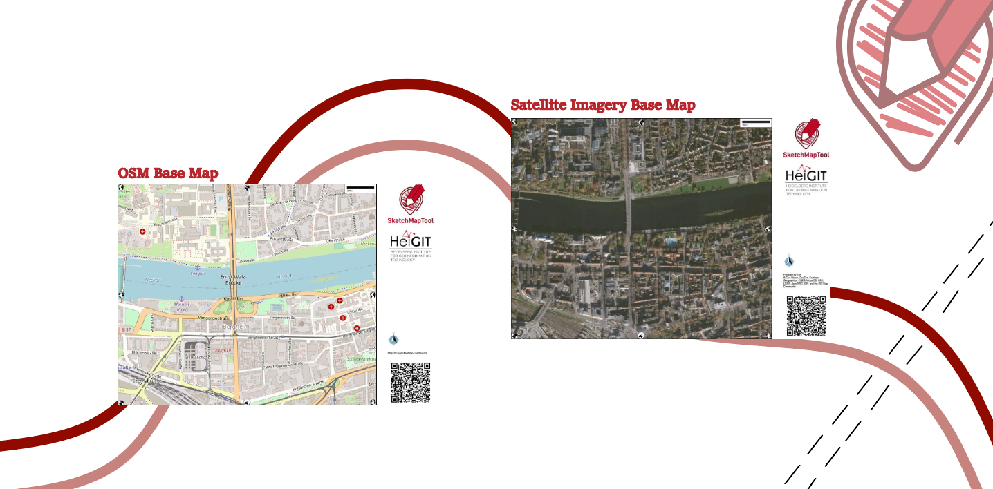
Unveiling the Sketch Map Tool 2.0: A Comprehensive Overview of New Features and Training Opportunities
The HeiGIT gGmbH (Heidelberg Institute for Geoinformation Technology) team has just released a version 2.0 of the Sketch Map Tool, a low-tech solution for participatory sketch mapping through offline data collection, digitization and georeferencing of local spatial knowledge. Thanks to continuous support from the German Red Cross and financial support by the German Federal Foreign Office, the HeiGIT tool has undergone significant enhancements. These updates introduce new features aimed…
-
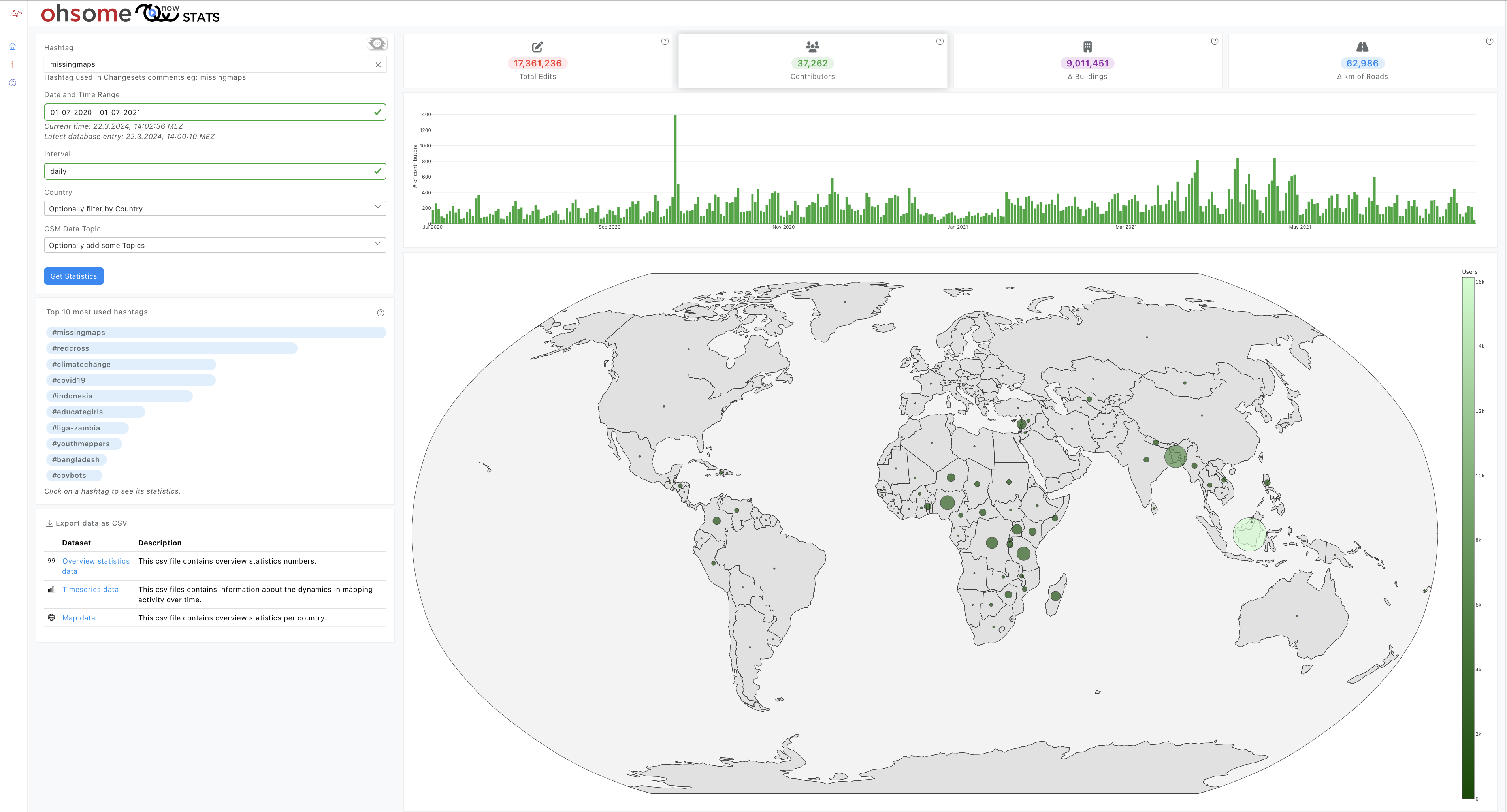
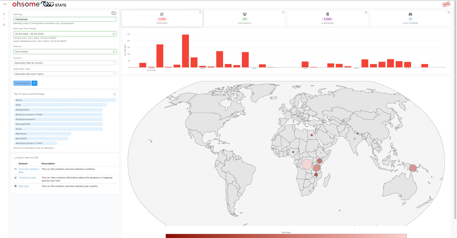
Introducing ohsomeNow stats v1.0
OhsomeNow stats makes it possible to monitor contributions to OpenStreetMap (OSM) in real time. We developed this new dashboard as part of our long-term cooperation with the Humanitarian OpenStreetMap Team (HOT), an international organization dedicated to humanitarian action and community development through open mapping. This dashboard has replaced the Missing Maps Leaderboard with a comprehensive overview…
-
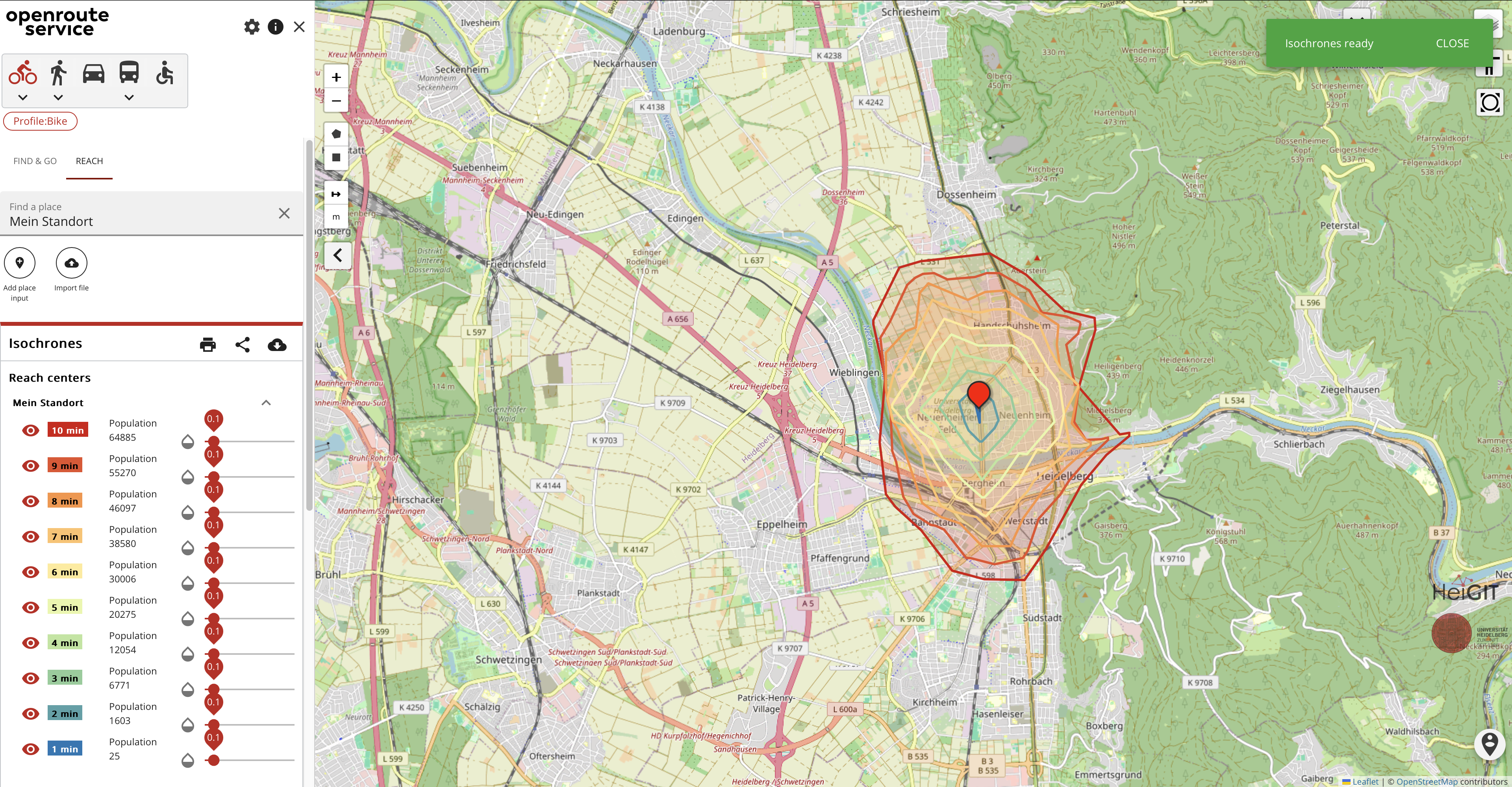
Introducing openrouteservice version 8.0 — A dedication to Wilfried Juling
We’re thrilled to announce the release of openrouteservice (ors) version 8.0, designated “Wilfried”, as a tribute to Prof. Dr. Wilfried Juling, whose steady support and advice fundamentally shaped the growth and success of HeiGIT since its beginning. With countless hours and dedication poured into development and innovation, we’re excited to present a rich set of…