

Search results for: “wheelchair”
-
Enrichment of OpenStreetMap Data Completeness with Sidewalk Geometries for Wheelchair Routing
Tailored routing and navigation services utilized by wheelchair users (such as provided by OpenRouteService.org ) require certain information about sidewalk geometries and their attributes to execute efficiently. Except some minor regions/cities, such detailed information is often not sufficiently present in current versions of crowdsourced mapping databases including OpenStreetMap. In a recent study (1) we aim…
-
Mapping for wheelchair users at Heidelberg castle gardens
On the occasion of the European protest day for equal rights of people with disabilities the Heidelberg advisory board of people with disabilities organises an event at Heidelberg castle tomorrow (30/4) from 2pm to 5pm. Our local CAP4ACCESS team is happy to join this event by leading mapping efforts to fill some data gaps in…
-
Option for wheelchair routing now available within OpenRouteService
We are happy to announce that the first version of the wheelchair routing profile is now available online within OpenRouteService and goes into beta testing phase. Currently, there is a separate version (http://openrouteservice.org/wheelchair-2.1/) for testing that contains this new feature, which currently covers Germany only. However, after beta testing, it will also be available via…
-
Measuring the Reliability of Wheelchair User Route Planning based on Volunteered Geographic Information (OpenStreetMap)
The development of a wheelchair user friendly route planning application inherits a number of special requirements and details that need to be considered during the generation of the routing graph and the corresponding algorithm, making this task much more complex than car or pedestrian related applications. Each wheelchair type and, more importantly, each individual user…
-
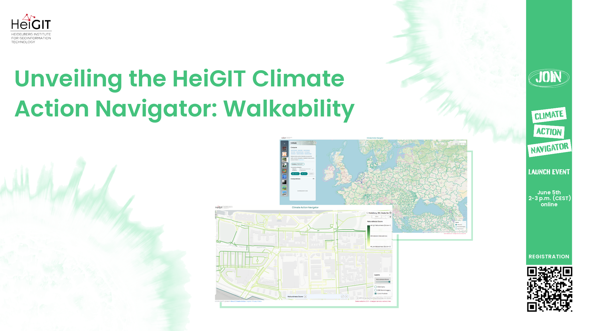
Unveiling the HeiGIT Climate Action Navigator Part 1 – Walkability
In just 22 days, on May 15th, we will officially launch the Climate Action Navigator (CAN): HeiGIT’s new dashboard offering high-resolution, open data-based insights into key climate action indicators. From assessing CO2 emissions from residential heating to urban active mobility infrastructure, CAN helps to identify where targeted action is most urgently needed. In this first…
-
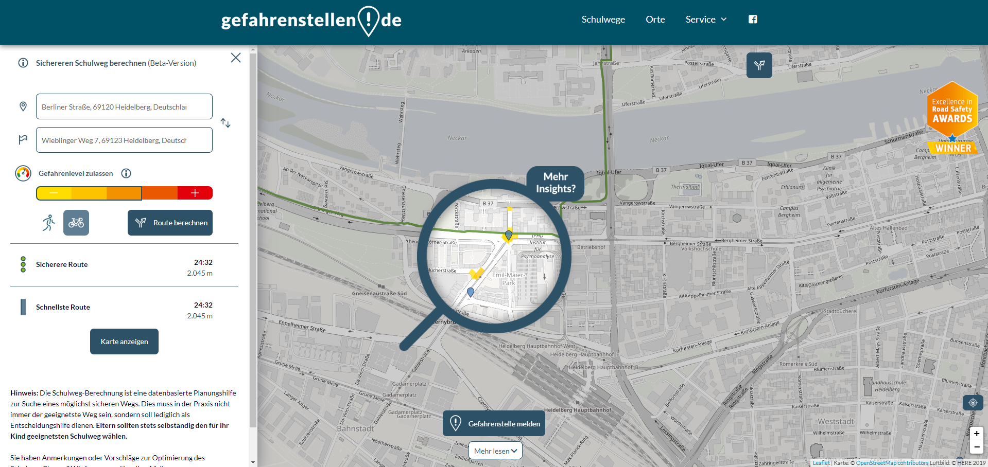
Enhancing school safety with openrouteservice: the digital school route planner
The OpenStreetMap (OSM) and openrouteservice (ORS) provide free geospatial data that serve a multitude of research and practical applications. OSM thrives on its community-driven approach, ensuring its data is always up-to-date and versatile. ORS takes this a step further by providing sophisticated routing services for various modes of transport, including walking, cycling, driving, and wheelchair…
-
Expanding Disaster Management Capabilities with openrouteservice
In the context of disaster management, time is of the essence. Quick and accurate response can make all the difference in saving lives and mitigating damage. That’s why the openrouteservice (ORS) for Disaster Management is taking a step forward by expanding its coverage to larger areas. This upgrade is set to improve the possibilities of…
-
How to become ohsome part 14 – Advanced dashboarding
Hello again and welcome back to our “How to become ohsome” series where we demonstrate how you too can become ohsome with ohsome API! If you’re new to the series or need a refresher, check out the older installments in our series, like this or this one covering the various ways of accessing ohsome API. And now to our…