

Tabernig, R., Albert, W., Weiser, H., Fritzmann, P., Anders, K., Rutzinger, M. & Höfle, B. (2025): Temporal aggregation of point clouds improves permanent laser scanning of landslides in forested areas. Science of Remote Sensing. Vol. 12, pp. 100254. DOI: https://doi.org/10.1016/j.srs.2025.100254
In our brand-new study ‘Temporal aggregation of point clouds improves permanent laser scanning of landslides in forested areas’, led by Ronald Tabernig, we have developed a new method that improves landslide monitoring – even when the ground is completely obscured by forest cover.
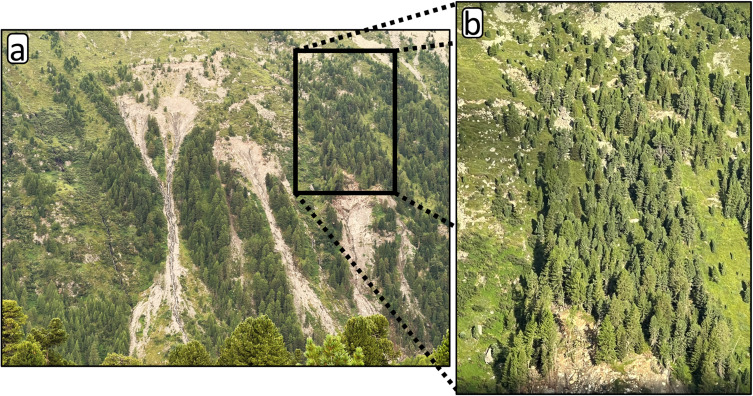
Modern 3D sensor systems can collect data almost continuously from a fixed position. For example, the permanent laser scanning system near Obergurgl in Tyrol (Austria) performs hourly scans of an active landslide. The result is a dense time series of 3D point clouds in which slope movement can be detected.
This makes it possible to identify dangers to people and infrastructure in good time and to issue warnings. However, if a landslide is densely covered with forest and the ground is therefore not visible at all, special methods are required. We derive the slope movement automatically by detecting the tree trunks in the landslide area and tracking them over time.
However, a single scan of the time series does not have sufficient resolution to reliably detect most of the tree trunks due to the distance of the scanner. By aggregating several consecutive scans, 5-6 times more trunks could be detected than without aggregation. Only then was it possible to quantify landslide movements across the entire area with high accuracy in the data set.

With the increase in gravitational mass events due to climate change, the use of such methods to protect the population and infrastructure is becoming increasingly important.
Funding
This work was supported by the Federal Ministry of Research, Technology and Space, Germany (Bundesministerium für Forschung, Technologie und Raumfahrt, BMFTR), in the frame of the AImon5.0 project (Funding code: 02WDG1696, 2023-2025) within the funding measure “Digital GreenTech – Umwelttechnik trifft Digitalisierung”.
This research was funded by the Deutsche Forschungsgemeinschaft (DFG), German Research Foundation, by the projects Extract4D (Grant Number: 535733258) and VirtuaLearn3D (Grant Number: 496418931).
We are grateful to the Baden-Württemberg Stiftung for the financial support of the research project CharAct4D through the Postdoctoral fellowship for leading early career researchers.