

Tag: 3D
-

3DGeo April Recap: Conferences
It was an exciting month for the 3DGeo research group in April. Three major conferences took place: Let’s give you some impressions below! JISDM The Joint International Symposium on Deformation Monitoring (JISDM) brings together experts on deformation monitoring from a range of fields such as photogrammetry, remote sensing and of course geodesy. It is a…
-
Deep learning with simulated laser scanning data for 3D point cloud classification
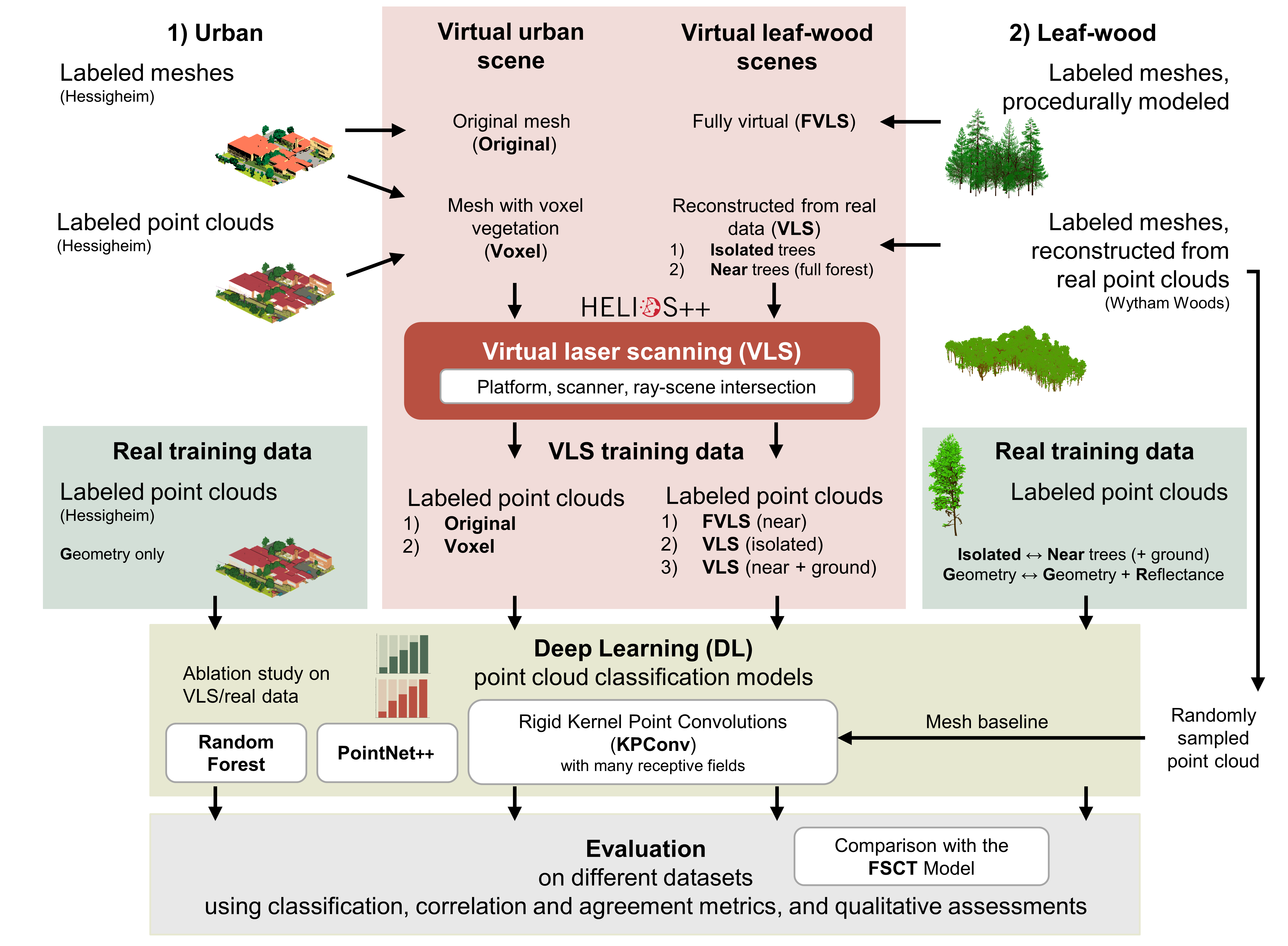
Esmorís, A.M., Weiser, H., Winiwarter, L., Cabaleiro, J.C. & Höfle, B. (2024): Deep learning with simulated laser scanning data for 3D point cloud classification. ISPRS Journal of Photogrammetry and Remote Sensing. Vol. 215, pp. 192-213. DOI: 10.1016/j.isprsjprs.2024.06.018 3D point clouds acquired by laser scanning are invaluable for the analysis of geographic phenomena. To extract information…
-
VirtuaLearn3D: New Preprint
We have published a preprint of our recent work in the VirtuaLearn3D project! Deep learning with simulated laser scanning data for 3D point cloud classification Esmorís, A.M., Weiser, H., Winiwarter, L., Cabaleiro, J.C. & Höfle, B. (2024) Laser scanning is an active remote sensing technique to acquire state-of-the-art spatial measurements in the form of 3D…
-
🦇 Halloween release of HELIOS++, v1.3.0
We proudly present our Halloween release of HELIOS++, Version 1.3.0: https://github.com/3dgeo-heidelberg/helios/releases What’s new in this release? HELIOS++ now supports LiDAR simulation of dynamic scenes. We can now simulate laser scanning of scenes that change during the simulation. This is done by introducing rigid motions, which are defined with XML syntax in the scene XML file.…
-
Impressions from Silvilaser 2023
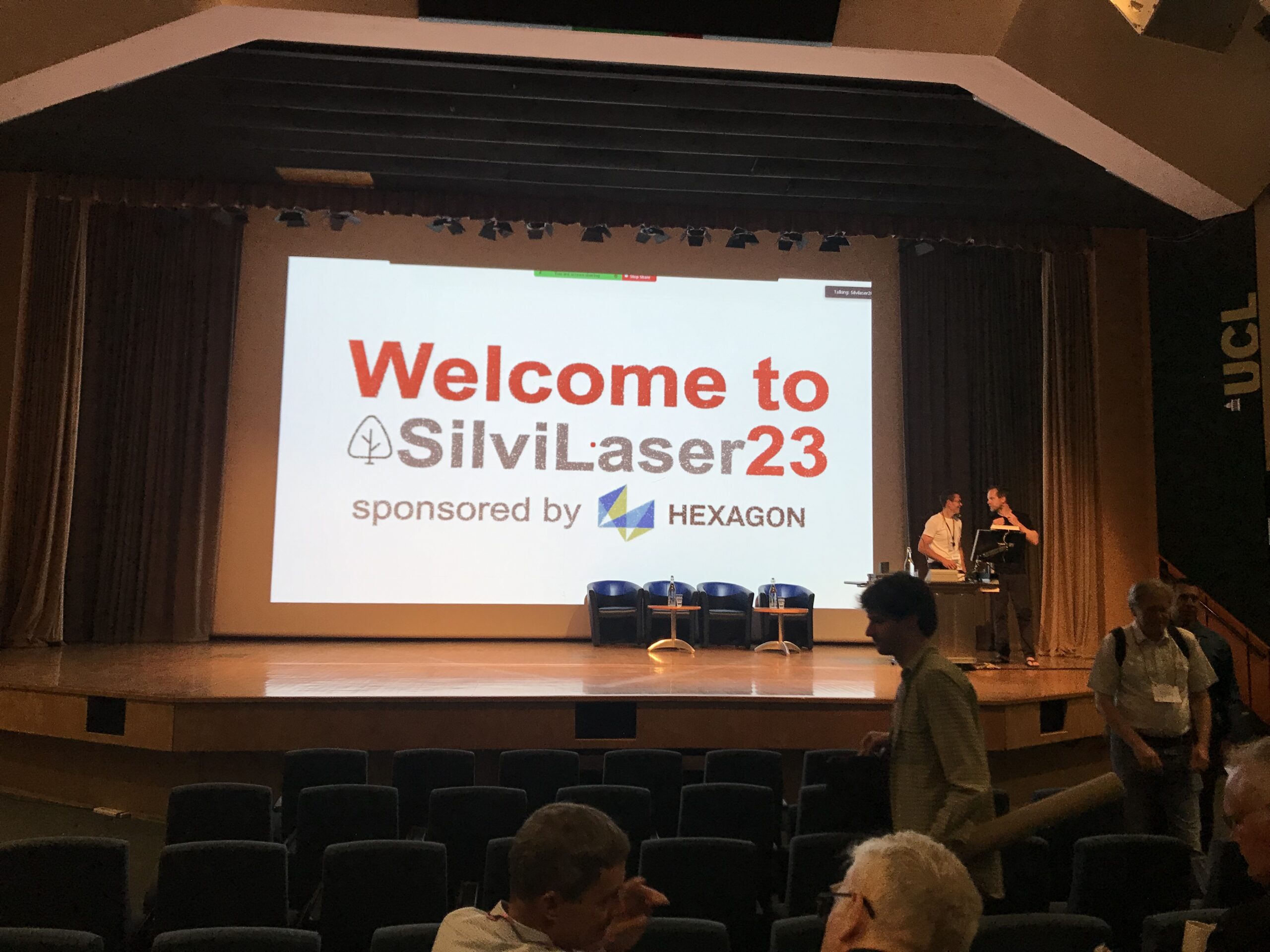
Last week, our PhD student, Hannah Weiser, joined Silvilaser 2023 at University College London (UCL). The conference covers cutting-edge science and technology from the laser scanning and forest communities, which is a perfect match for Hannah’s PhD topic and 3DGeo research in general. The week started off with interesting workshops on Tuesday using some of…
-
Introducing the VirtuaLearn3D Project
With VirtuaLearn3D (Virtual Laser Scanning for Machine Learning Algorithms in Geographic 3D Point Cloud Analysis), a new project of the 3DGeo group has started. The focus of this project is to enable powerful machine learning algorithms for geographic point cloud analysis by advancing the concept of virtual laser scanning to overcome the lack of training…
-
CharAct4D – Unravelling Landscape Dynamics via Automatic Characterization of Surface Activity using Geographic 4D Monitoring
With her new project CharAct4D Dr. Katharina Anders has become part of the Eliteprogramme for Postdocs of the Baden-Württemberg Stiftung, which supports early career researchers to qualify for a professorship -check the related press release by Heidelberg University. Many congratulations, Katharina! Katharina’s research interests in the 3DGeo research group are method development for 3D/4D change analysis…
-
3DGeo at AGU21 Fall Meeting
The 3DGeo research group is part of the AGU Fall Meeting from 13 – 17 December 2021 with the following topics and contributions: 1) Hypersurface Observation Network (Hyperon) — What it is and why we need it (Monday, 13 December 2021 16:00 – 18:00 CST) In the terrestrial domain, large biogeochemical and energetic uncertainties surround the…
-
Open laser scanning data of trees – SYSSIFOSS project
Our forest laser scanning dataset collected in the frame of the SYSSIFOSS project is now openly available through the PANGAEA Data Publisher: Weiser, H., Schäfer, J., Winiwarter, L., et al. (2021): Terrestrial, UAV-borne and airborne laser scanning point clouds of central European forest plots, Germany, with extracted individual trees and manual forest inventory measurements. PANGAEA,…
-
SYSSIFOSS at EGU21 on 26 April
From 19 to 30 April 2021, European researchers from the Earth, planetary and space sciences are gathering in the virtual European Geosciences Union (EGU) assembly. On Monday, 26 April, two SYSSIFOSS presentations will be opening the block “Point clouds for forestry applications” in session BG11 – Remote sensing for forest applications. Dr. Fabian E. Fassnacht…
-
Fully automatic spatiotemporal segmentation of 3D LiDAR time series for the extraction of natural surface changes
When and where do changes occur in dynamic natural landscapes? A new method has been published that enables the automatic extraction of surface changes from entire time series of 3D point clouds. The developed method of spatiotemporal segmentation extracts changes regarding their surface change history, which makes it particularly useful for natural scenes that are…
-
HELIOS++ 1.0.0 Software & Preprint Release
The 3DGeo Research Group is proud to announce the release of their novel ray-tracing based laser scanning simulator HELIOS++! HELIOS++ is a general-purpose simulation software for virtual laser scanning data acquisition. Such data can be used to complement real data in many use cases. Some examples include the generation of training data for machine learning,…