

On the 19th of September 2021 a volcanic eruption on the Canary Island of La Palma started.
Since then the resulting lava field is constantly growing and continues its destructive expansion. According to an article in the spanish newspaper El Pais, after one month of eruptions – till 19th of Oktober 2021- the volcano destroyed about 1700 buildings, over 50 km of roads and its lava fiels covered about 760 ha of land.
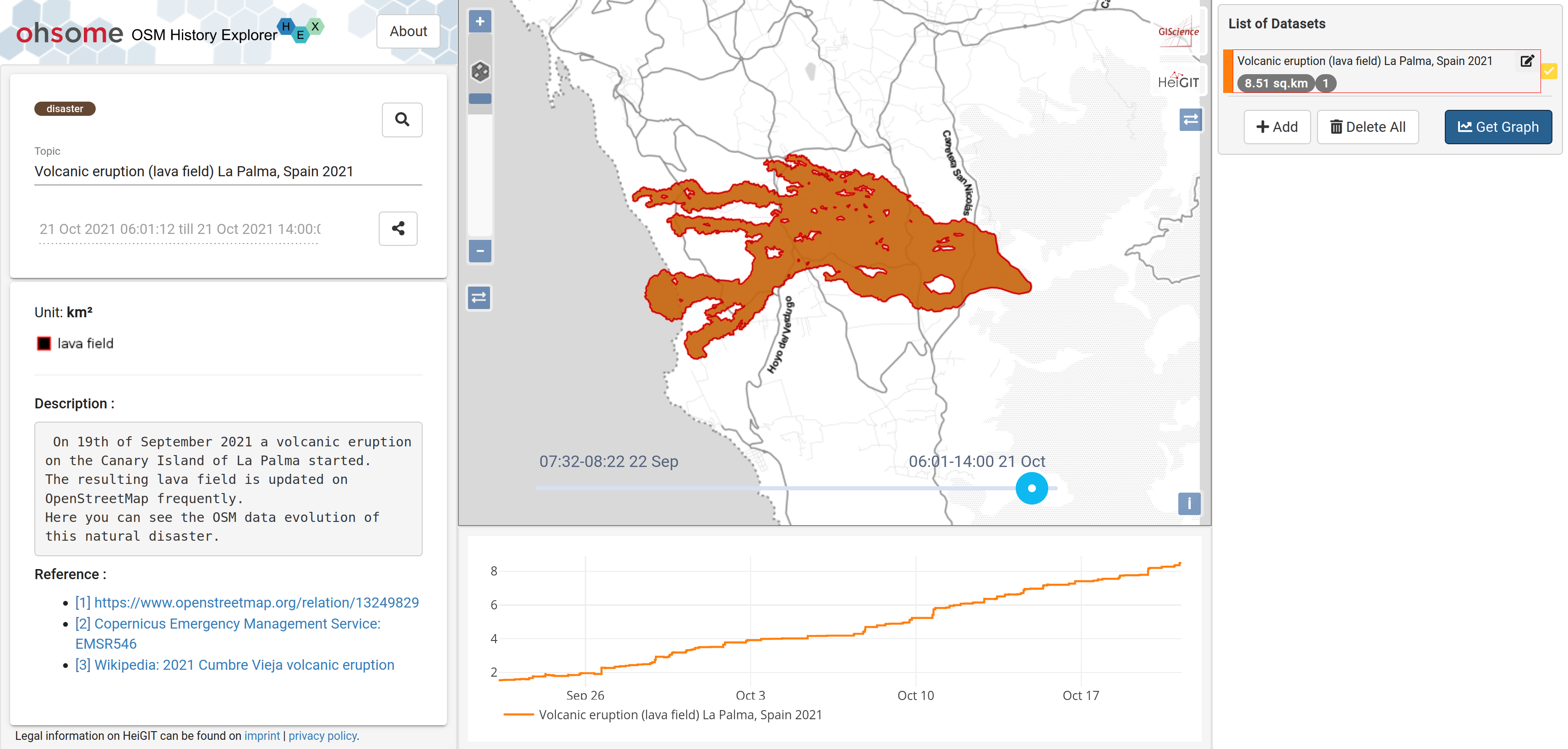
Figure 1: ohsomeHeX showing the lava lield of the volcanic eruption in La Palma (Spain) 2021
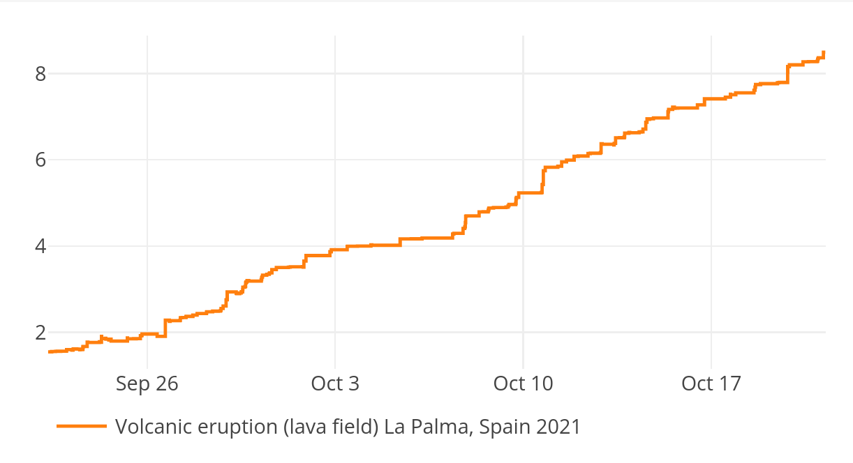
Figure 2: Area in km² that has been covered by the lava field in La Palma (Spain)
The outline of the lava field gets updated frequently in OpenStreetMap (OSM). This is mainly based on local observations and drone flight data available on https://www.opendatalapalma.es/.
The HeiGIT ohsome team made the contributor’s efforts of keeping OSM up-to-date during such a natural disaster event visible by leveraging HeiGIT’s technology to extract full-history OSM data using the ohsome API. These data contain every single map edit and can be temporally explored on ohsomeHeX (https://ohsome.org/apps/osm-history-explorer/#/volcano_eruption_la_palma_spain_202109/2021-10-21T06:01:12Z%2F2021-10-21T14:00:00Z/13/28.616173745603703/-17.89821350736635). Currently we are checking for OSM updates on an hourly basis, so bookmark the ohsomeHeX link and be informed on the future developments in La Palma.
Related Links:
- Map on ohsomeHeX: Open ohsomeHeX map here
- ohsome general idea
- ohsome general architecture
- how to become ohsome blog series
- El PAIS (article): https://english.elpais.com/spain/2021-10-19/one-month-on-la-palma-volcano-continues-to-cause-destruction.html
- La Palma Open Data Portal: https://www.opendatalapalma.es/
- Copernicus EMS: EMSR546: Volcano eruption in La Palma, Spain
- Wikipedia: 2021 Cumbre Vieja volcanic eruption
- OSM: https://www.openstreetmap.org/relation/1324982
Related Publications (ohsome spatiotemporal analysis):
- Raifer, Martin; Troilo, Rafael; Kowatsch, Fabian; Auer, Michael; Loos, Lukas; Marx, Sabrina; Przybill, Katharina; Fendrich, Sascha; Mocnik, Franz-Benjamin; Zipf, Alexander (2019): OSHDB: a framework for spatio-temporal analysis of OpenStreetMap history data. Open Geospatial Data, Software and Standards.
- Auer, M.; Eckle, M.; Fendrich, S.; Griesbaum, L.; Kowatsch, F.; Marx, S.; Raifer, M.; Schott, M.; Troilo, R.; Zipf, A. (2018): Towards Using the Potential of OpenStreetMap History for Disaster Activation Monitoring. ISCRAM 2018. Rochester. NY. US.
- Herfort, B., Lautenbach, S., Porto de Albuquerque, J., Anderson, J., Zipf, A.The evolution of humanitarian mapping within the OpenStreetMap community. Scientific Reports 11, 3037 (2021). DOI: 10.1038/s41598-021-82404-z https://www.nature.com/articles/s41598-021-82404-z
- Schott, M.; Grinberger, A. Y.; Lautenbach, S. & Zipf, A. (2021): The Impact of Community Happenings in OpenStreetMap – Establishing a Framework for Online Community Member Activity Analyses. ISPRS Int. J. Geo-Inf. 10, no. 3: 164. https://doi.org/10.3390/ijgi10030164
- Grinberger, AY, Schott, M, Raifer, M, Zipf, A. (2021): An analysis of the spatial and temporal distribution of large‐scale data production events in OpenStreetMap. Transactions in GIS. 2021; 00: 1– 20. https://doi.org/10.1111/tgis.12746
- Witt, R.; Loos, L.; Zipf, A. (2021): Analysing the Impact of Large Data Imports in OpenStreetMap. ISPRS Int. J. Geo-Inf. 2021, 10, 528. https://doi.org/10.3390/ijgi10080528
- Fritz, O., Auer, M., Zipf, A. (2021). Entwicklung eines Regressionsmodells für die Vollständigkeitsanalyse des globalen OpenStreetMap-Datenbestands an Nahverkehrs-Busstrecken. AGIT ‒ Journal Für Angewandte Geoinformatik. 7-2021
- Yang, A., H. Fan, N. Jing, Y. Sun, A. Zipf (2016): Temporal Analysis on Contribution Inequality in OpenStreetMap: A Comparative Study for Four Countries. ISPRS Int. Journal of Geo-Information. 5(1), 5.