

Earlier we published several blogposts introducing the ohsome platform and its parts (e.g. the ohsome API for example, which was often showcased here in the blog) and its backbone the OSHDB (very recently version 0.5 was published). A recent open access journal article gives even more background to the system, as shown below:
Raifer, M, Troilo, R, Kowatsch, F, Auer, M, Loos, L, Marx, S, Przybill, K, Fendrich, S, Mocnik, FB & Zipf, A (2019): OSHDB: a framework for spatio-temporal analysis of OpenStreetMap history data. Open Geospatial Data, Software and Standards, https://doi.org/10.1186/s40965-019-0061-3.
The OpenStreetMap History Database (OSHDB) is a new data analysis tool for spatio-temporal geographical vector data. It is specifically optimized for working with OSM history data on a global scale and allows one to investigate the data evolution and user contributions in a flexible way. Benefits of the OSHDB are for example: to facilitate accessing OSM history data as a research subject and to assess the quality of OSM data by using intrinsic measures.
The article describes the requirements of such a system and the resulting technical implementation of the OSHDB: the OSHDB data model and its application programming interface.
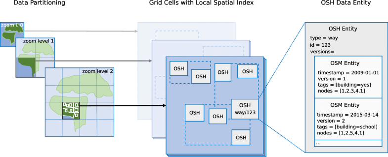
Its design goals, and an overview of the technical implementation is given in the “Implementation” section: The OSHDB follows a modular approach: on top of a specially designed data model, a map-reduce based API allows users to implement their own data analysis applications.
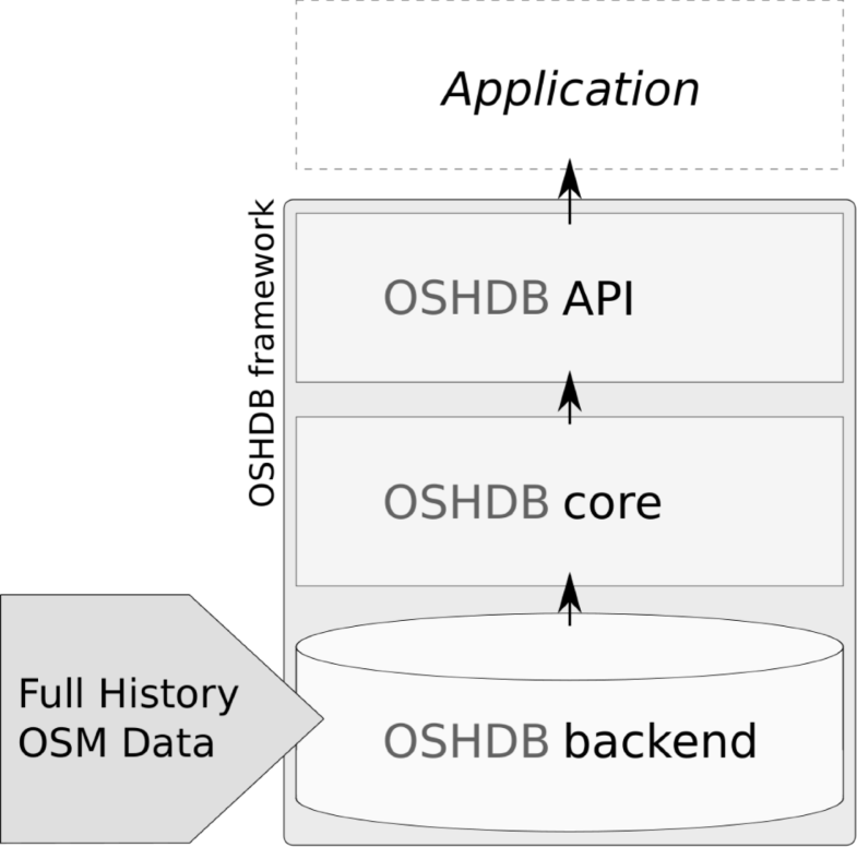
Starting from the low level data structures described in the “Data model” section, the API – called OSHDB-API – builds a few layers of abstraction.
The OSHDB also allows parallelized computation on a distributed compute cluster. As it is discussed in the “Application programming interface” section, the API is flexible and thus not tailored to a specific application. The API can rather be used for a broad range of applications. Examples for such applications are intrinsic data quality assessment, or creating large scale data visualizations.
First applications include the global ohsome dashboard or the OSM History eXplorer ohsomeHeX.
Stay tuned for updates of the framework.
You can find the OSHDB source code as open-source under the LGPLv3 license on github. Don’t hesitate to open a ticket there if you encounter any bugs or are missing a particular feature in the OSHDB or want to contribute and feel free to contact us via email to info@heigit.org.
Reference:
If you are using the OSHDB and ohsome framework for your work, please cite this paper for reference.
Raifer, M, Troilo, R, Kowatsch, F, Auer, M, Loos, L, Marx, S, Przybill, K, Fendrich, S, Mocnik, FB & Zipf, A (2019): OSHDB: a framework for spatio-temporal analysis of OpenStreetMap history data. Open Geospatial Data, Software and Standards, https://doi.org/10.1186/s40965-019-0061-3.
Earlier work on using the platform, e.g.:
Auer, M.; Eckle, M.; Fendrich, S.; Griesbaum, L.; Kowatsch, F.; Marx, S.; Raifer, M.; Schott, M.; Troilo, R.; Zipf, A. (2018): Towards Using the Potential of OpenStreetMap History for Disaster Activation Monitoring. ISCRAM 2018. Rochester. NY. US.