

Tag: OpenStreetMap
-
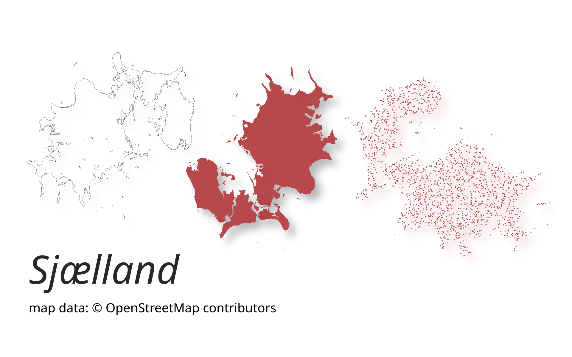
New release of ohsome-planet: Even faster processing of OSM history data in GeoParquet format
A new version of ohsome-planet (codename “Sjælland”) has been released. It is the newest version of HeiGIT´s command line tool, which transforms OpenStreetMap (history) PBF files into into an analysis-ready data format. We illustrate what ohsome-planet can do by assessing how many OSM edits used Bing Imagery as reference source. What is ohsome-planet? Working with…
-
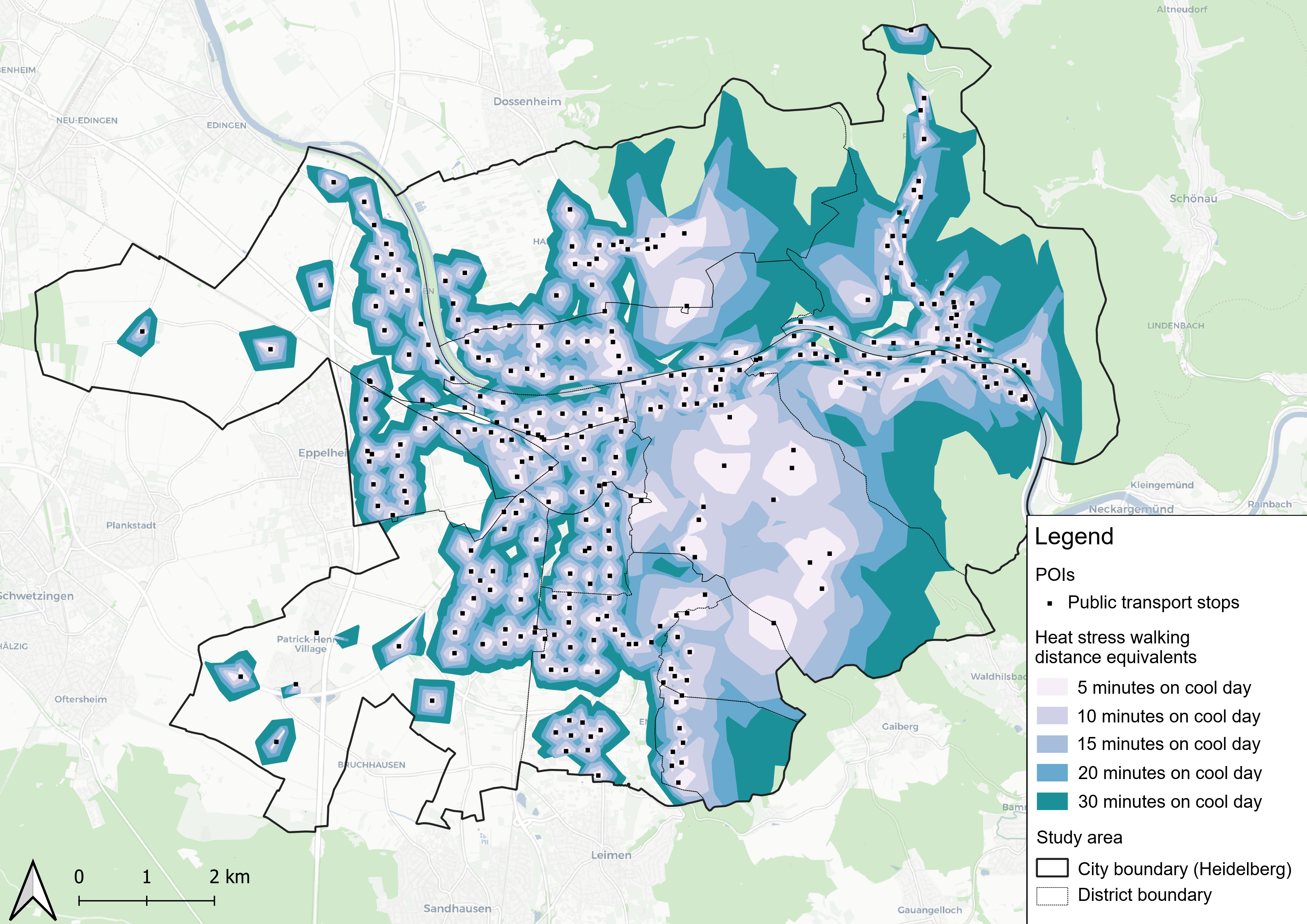
New Paper “Accessibility for pedestrians under heat stress – the example of Heidelberg, Germany”
This study introduces the isocalor approach to assess how solar exposure and heat stress impact pedestrian access to essential services in Heidelberg, using OpenStreetMap data and a customized openrouteservice routing engine. As climate change intensifies, cities are increasingly exposed to extreme heat events, with urban populations—especially vulnerable groups like older adults, children, and those with…
-
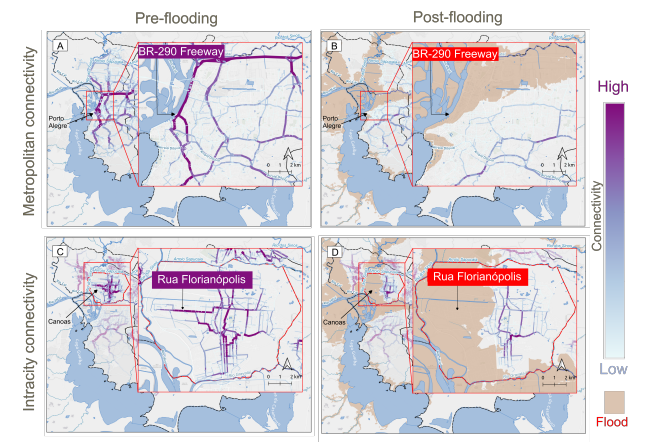
New paper “Changes in Road Centrality and Hospital Access Redundancy: Impacts of the 2024 Flood in the Metropolitan Core of Porto Alegre”
This study examines the resilience of urban infrastructure, with a focus on road network connectivity and redundancy in the face of extreme weather events. Using OpenStreetMap (OSM) data and the openrouteservice (ORS) routing engine, the research assesses centrality metrics and redundancy to evaluate how floods impact mobility and access to critical services, such as healthcare.…
-
New Paper “Lessons in Traffic: Nairobi’s School Term Congestion and Equity Challenges”
This study, published at African Transport Studies, investigates the impact of school sessions on traffic congestion in Nairobi, highlighting how children’s mobility needs are often overlooked in transport planning. The paper explores how poor integration of school-related travel into urban transport planning contributes to traffic congestion in Nairobi. While the conventional response to congestion has…
-
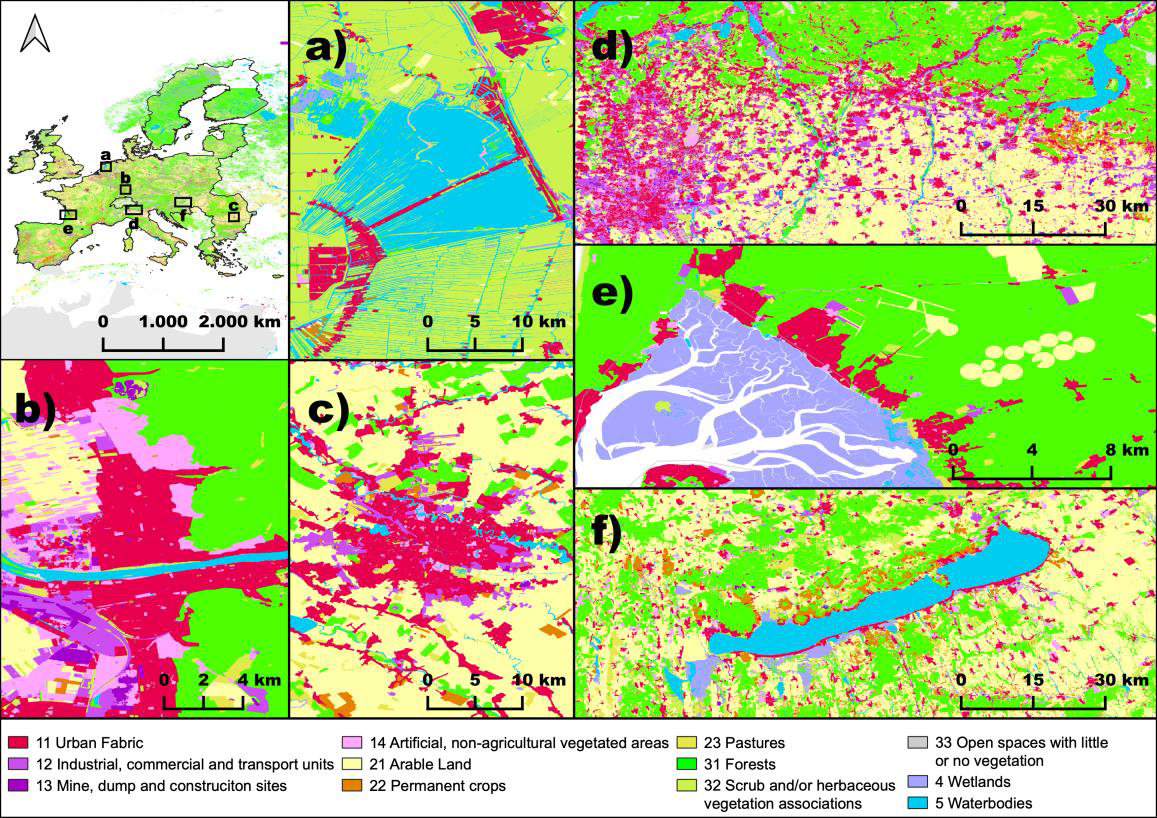
New Paper in Nature “OSMlanduse a dataset of European Union land use at 10 m resolution derived from OpenStreetMap and Sentinel-2”
The paper, published in Nature Scientific Data, presents the first high-resolution (10m or finer) land use map of the European Union derived from a large-scale fusion of OpenStreetMap (OSM) and Copernicus Sentinel-2 data. Leveraging citizen-generated data and remote sensing, the authors demonstrate a scalable and globally applicable methodology to fill thematic and spatial gaps in…
-
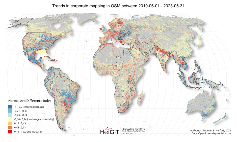
New paper “Corporate Mapping in OpenStreetMap – shifting trends in global evolution and small-scale effects”
Since 2016, corporate involvement in OpenStreetMap (OSM) has grown significantly, with major contributors such as Apple, Microsoft, Meta, and Amazon making substantial edits to the map on a global scale. These efforts have often focused on filling gaps in high- and medium-income countries, contributing to the overall growth of OSM data. However, this increasing corporate…
-
First release of ohsome-planet: OSM history data in GeoParquet format
We’re excited to share the release of the ohsome-planet – a new software library on GitHub, marking a significant step toward the development of ohsome 2.0. This tool is designed to facilitate the transformation of raw OpenStreetMap (OSM) history data into the GeoParquet format, making it more accessible and efficient for spatial data analysis. What…
-
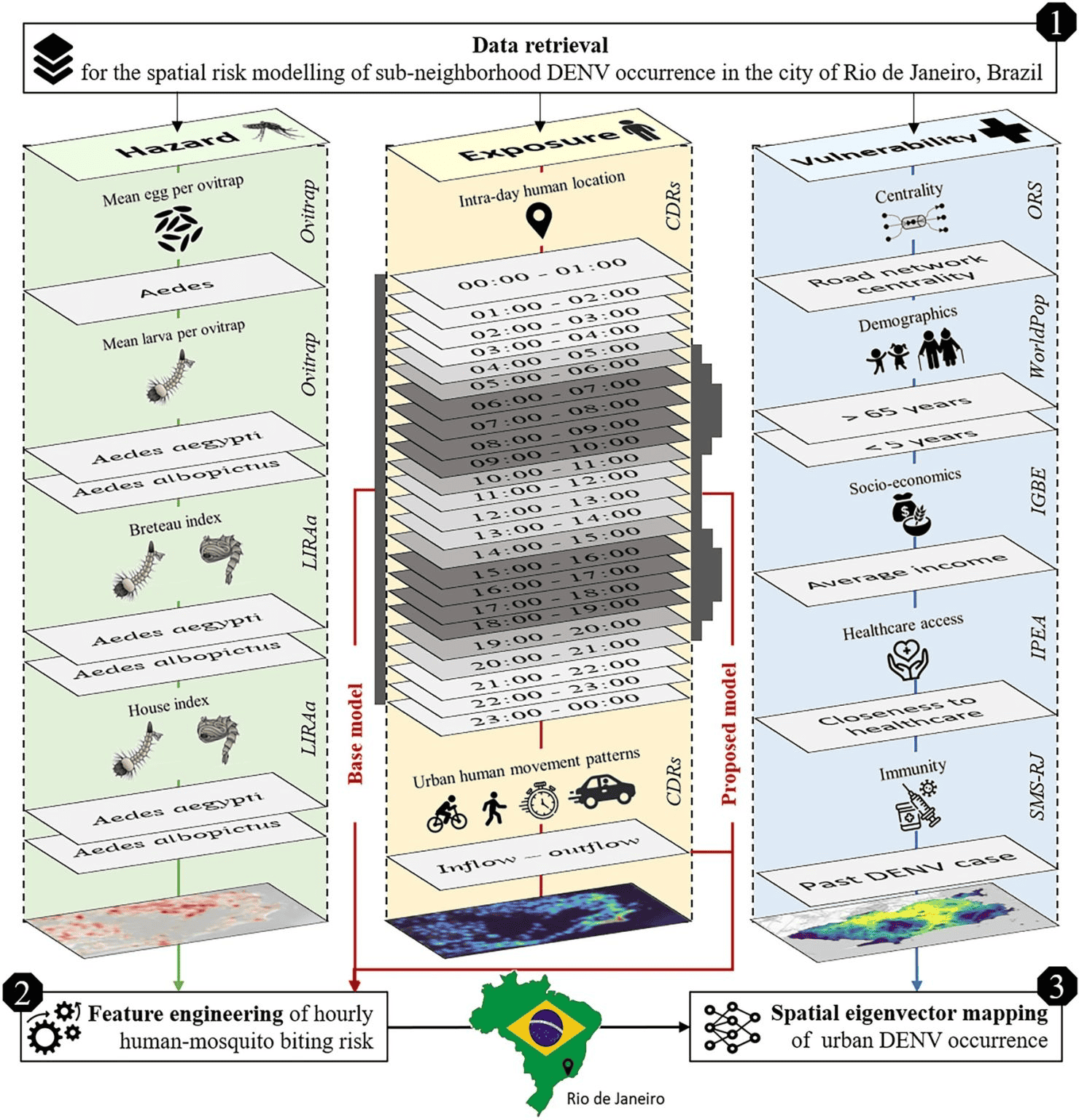
New Paper in Scientific Reports “Modeling Intraday Aedes-human exposure dynamics enhances dengue risk prediction”
Scientific Reports publishes a paper by Steffen Knoblauch et al. that underscores the critical importance of integrating vector ecology and human behavior into advanced disease modeling frameworks. The increasing availability of human movement data presents significant potential for tackling global public health challenges, especially in the context of infectious diseases. This is particularly important for…
-
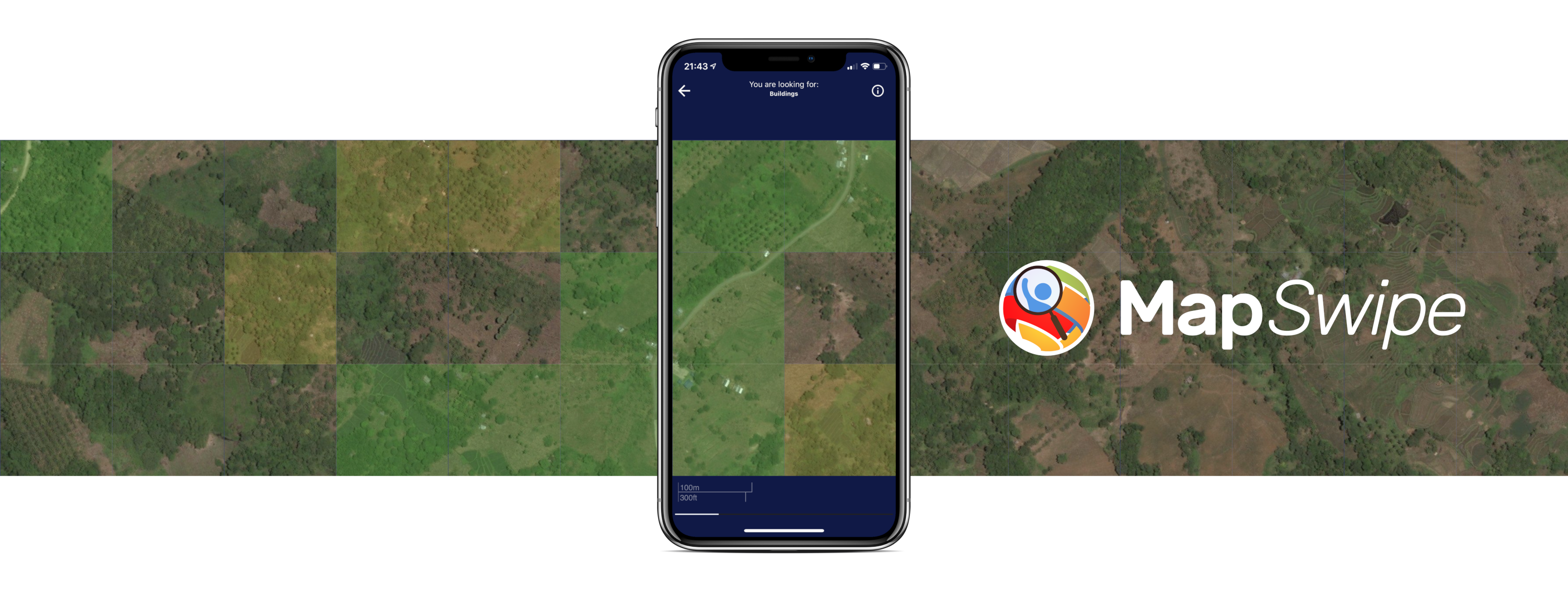
Crowdmapping on Street-Level Imagery with MapSwipe
The crowdmapping app MapSwipe now integrates also street-level imagery. This new feature enables even mapping efforts that require the highest level of detail, such as detecting waste on the street. The MapSwipe App MapSwipe is an open-source app that enables volunteers to map missing geodata, making global mapping efforts more coordinated and efficient. Free, reliable geodata…
-
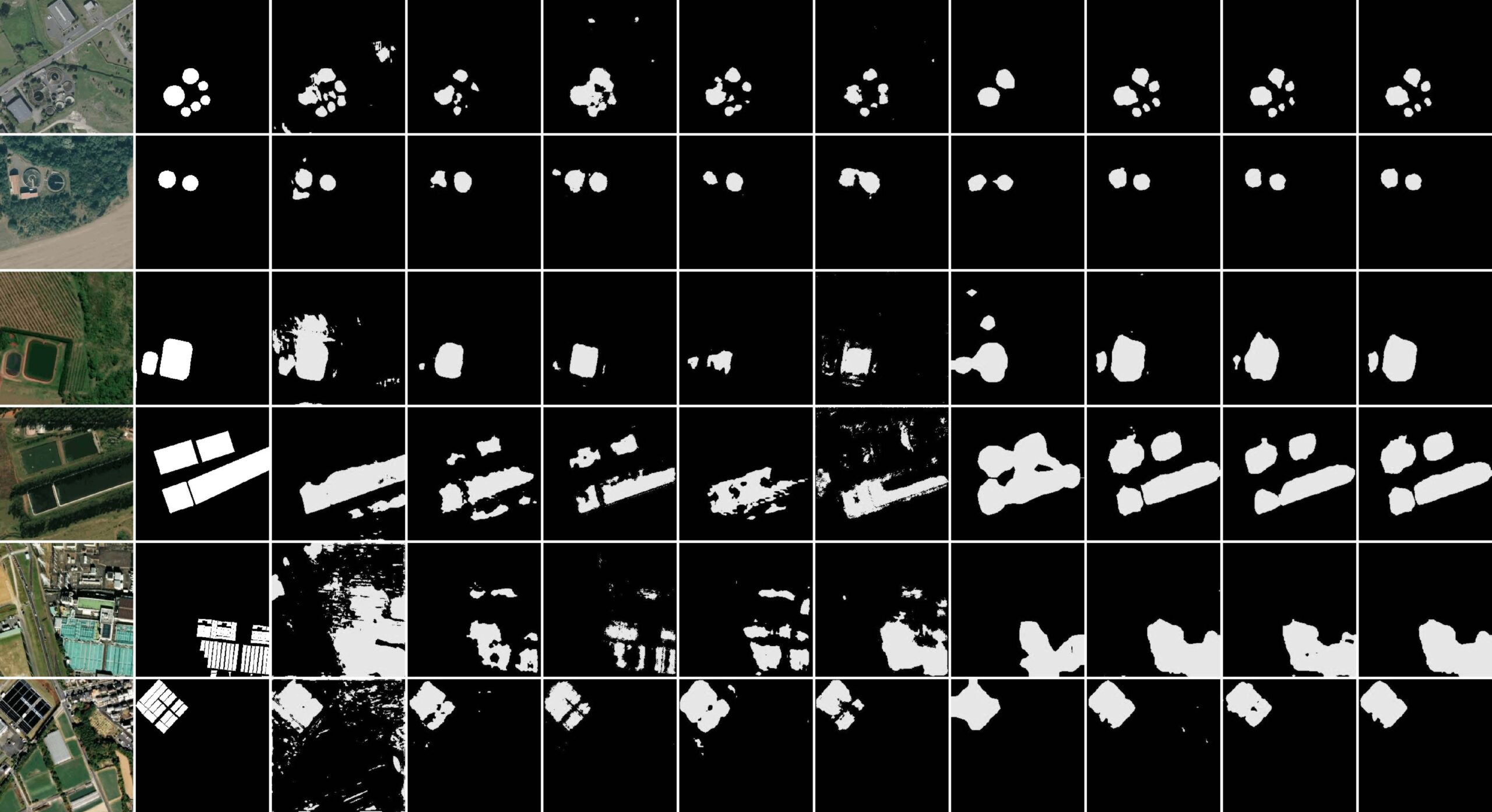
New paper “STVAE: Skip connection driven two-stream property Fusion Variational AutoEncoder for cross-region wastewater treatment plant semantic segmentation”
Wastewater treatment plants (WWTPs) play a crucial role in maintaining ecological balance and public health and are essential for advancing social sustainable development goals. However, the diverse architectural styles, scales, and environmental contexts of WWTPs—shaped by climate, topography, and regional economic conditions—pose significant challenges for generalizing segmentation algorithms. To address this, integrating knowledge from different…
-
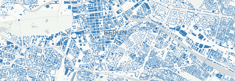
OSM Completeness with Overture maps data
Free and open-source map data has become a keystone for research across diverse fields. The extensive coverage of OpenStreetMap (OSM) data allows scientists to conduct independent studies without relying on corporate collaborations or investing heavily in proprietary datasets. However, OSM data coverage completeness varies significantly by location. Moreover, the latest data updates cannot always be…
-
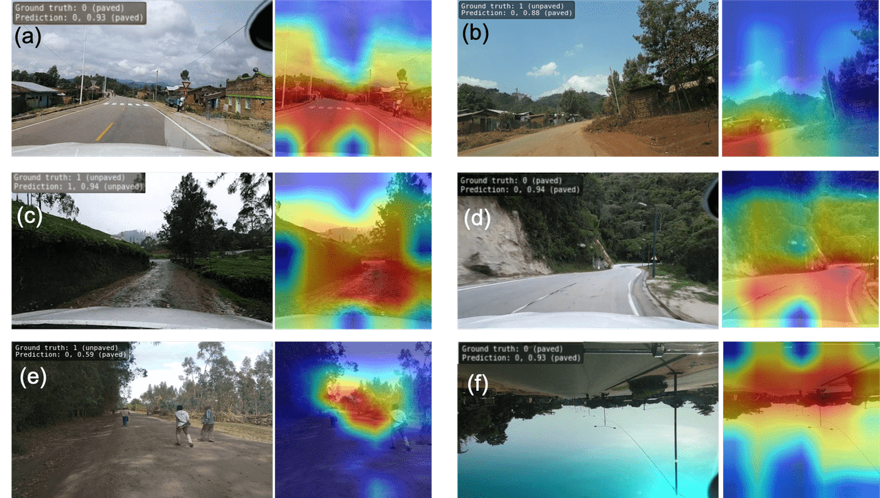
Accurate road surface data for transportation, safety, and economic development
Researchers at HeiGIT (Heidelberg Institute for Geoinformation Technology) have publicly released a first of its kind planet-scale dataset on road surface type (paved or unpaved) using state-of-the-art GeoAI methods based on street-view imagery from Mapillary, in order to support humanitarian response, urban planning and progress towards the Sustainable Development Goals. Road surface information plays an essential…