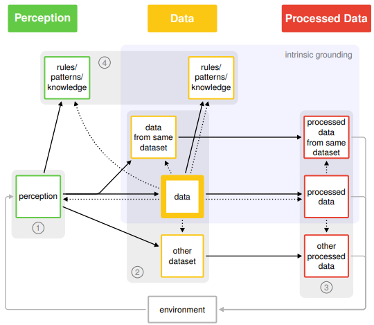
Data quality and fitness for purpose can be assessed by data quality measures. Existing ontologies of data quality dimensions reflect, among others, which aspects of data quality are assessed and the mechanisms that lead to poor data quality. An understanding of which source of information is used to judge about data quality and fitness for purpose is, however, lacking. We have introduced an ontology of data quality measures by their grounding, that is, the source of information to which the data is compared to in order to assess their quality. The ontology is exemplified with several examples of volunteered geographic information (VGI), while also applying to other geographical data and data in general. An evaluation of the ontology in the context of data quality measures for OpenStreetMap (OSM) data, a well-known example of VGI, provides insights about which types of quality measures for OSM data have and which have not yet been considered in literature.

Further reading:
Mocnik, F. B., Mobasheri, A., Griesbaum, L., Eckle, M., Jacobs, C., & Klonner, C. (2018). A grounding-based ontology of data quality measures. Journal of Spatial Information Science (16), 1-25.
Relevant Publications on the topic of OSM/VGI data quality:
- Mocnik, F.-B., Zipf, A., Raifer, M. (2017): The OpenStreetMap folksonomy and its evolution. Geo-spatial Information Science. Vol 20, 219-230. DOI: 10.1080/10095020.2017.1368193.
- Degrossi L.C., J. Porto de Albuquerque, R. dos Santos Rocha, A. Zipf (2018): A taxonomy of quality assessment methods for volunteered and crowdsourced geographic information.Transactions in GIS (TGIS). Wiley. DOI:10.1111/tgis.12329
- Mocnik, F. B., Mobasheri, A., Zipf, A.(2018). Open Source Data Mining Infrastructure for Exploring and Analysing OpenStreetMap. Journal of Open Geospatial Data, Software and Standards, 3: 7, doi: https://doi.org/10.1186/s40965-018-0047-6
- Senaratne, H., Mobasheri, A., Ali, A.L. , Capineri, C, and Haklay, M. (2017): A review of Volunteered Geographic Information quality assessment methods. International Journal of Geographical Information Science (IJGIS), 31(1), 139-167. DOI:10.1080/13658816.2016.1189556
- Ballatore, A. and Zipf, A. (2015): A Conceptual Quality Framework for Volunteered Geographic Information. COSIT – Conference on Spatial Information Theory XII. 2015. Santa Fe, New Mexico, USA. Lecture Notes in Computer Science, pp. 1-20.


