

Search results for: “machine learning”
-
Inferencing indoor room semantics using random forest and relational graph convolutional networks (deep learning)
Semantically rich maps are the foundation of indoor location‐based services. Many map providers such as OpenStreetMap and automatic mapping solutions focus on the representation and detection of geometric information (e.g., shape of room) and a few semantics (e.g., stairs and furniture) but often still neglect room usage. To mitigate the issue, a new published paper…
-
MAN & MACHINE portrayed in the Forschungsmagazin “Ruperto Carola”
Can the human brain be described as a kind of machine – and, by extension, human memory as a time machine? What do software and the human mind have in common, and what are the ethical dilemmas involved in the use of artificial intelligence (AI)? Neurobiologist Hannah Monyer and geoinformatics expert Bernhard Höfle present talking…
-
Introducing ohsome2label tool to generate training samples from OpenStreetMap for geospatial deep learning
After more than a decade of rapid development of volunteered geographic information (VGI), VGI has already become one of the most important research topics in the GIScience community. Almost in the meantime, we have witnessed the ever-fast growth of geospatial deep learning technologies to develop smart GIServices and to address remote sensing tasks, for instance,…
-
New DFG project: IdealVGI – Deep Learning with OSM
Recently a new DFG project proposal was accepted to the GIScience Research Group Heidelberg within the DFG priority programme VisVGI (Volunteered Geographic Information: Interpretation, Visualisation and Social Computing” [SPP 1894]). It is joint collaboration project together with Prof. Begüm Demir from TU Berlin. IDEAL-VGI: Information Discovery from Big Earth Observation Data Archives by Learning from…
-
Mapping Human Settlements with Higher Accuracy and Less Volunteer Efforts by Combining Crowdsourcing and Deep Learning
Our new paper on Machine Learning and Humanitarian Mapping Nowadays, Machine Learning and Deep Learning approaches are steadily gaining popularity within the humanitarian (mapping) community. New tools such as the ML Enabler or the rapId editor might change the way crowdsourced data is produced in the future. Hence, at the Heidelberg Institute for Geoinformation Technology…
-
Paper on Analysis of Feature Relevance in Deep Learning for 3D Point Cloud Classification
A paper investigating the relevance of (pre-calculated) features for 3D point cloud classification using deep learning was just published in the ISPRS Annals of Photogrammetry and Remote Sensing. The study presents a non-end-to-end deep learning classifier for 3D point clouds using multiple sets of input features and compares it with an implementation of the state-of-the-art…
-
Deep Learning from Multiple Crowds: A Case Study of Humanitarian Mapping
Our paper about Deep Learning from Multiple Crowds: A Case Study of Humanitarian Mapping is available online now. Satellite images are widely applied in humanitarian mapping which labels buildings, roads and so on for humanitarian aid and economic development. However, the labeling now is mostly done by volunteers. In a recently accepted study, we utilize deep…
-
Deep Learning from Multiple Crowds: A Case Study of Humanitarian Mapping
Satellite images are widely applied in humanitarian mapping which labels buildings, roads and so on for humanitarian aid and economic development. However, the labeling now is mostly done by volunteers. In a recently accepted study, we utilize deep learning to solve humanitarian mapping tasks of a mobile software named MapSwipe. The current deep learning techniques…
-
Deep Learning with Satellite Images and Volunteered Geographic Information
Recently, deep learning has been widely applied in pattern recognition with satellite images. Deep learning techniques like Convolutional Neural Network and Deep Belief Network have shown outstanding performance in detecting ground objects like buildings and roads, and the learnt deep features are further applied in some prediction tasks like poverty and population mapping. On the…
-
DeepVGI: Deep Learning with Volunteered Geographic Information
Deep learning techniques, esp. Convolutional Neural Networks (CNNs), are now widely studied for predictive analytics with remote sensing images, which can be further applied in different domains for ground object detection, population mapping, etc. These methods usually train predicting models with the supervision of a large set of training examples. However, finding ground truths especially…
-
Artificial Intelligence in Anticipatory Action: Insights and Lessons Learned
Artificial Intelligence holds great promise for strengthening Anticipatory Action by improving hazard forecasting, vulnerability mapping, and decision support, but must be tailored to real-world humanitarian contexts to really be of benefit. A recent workshop brought together practitioners, researchers, and tech experts to identify gaps, share learnings, and explore how AI can be responsibly and effectively…
-
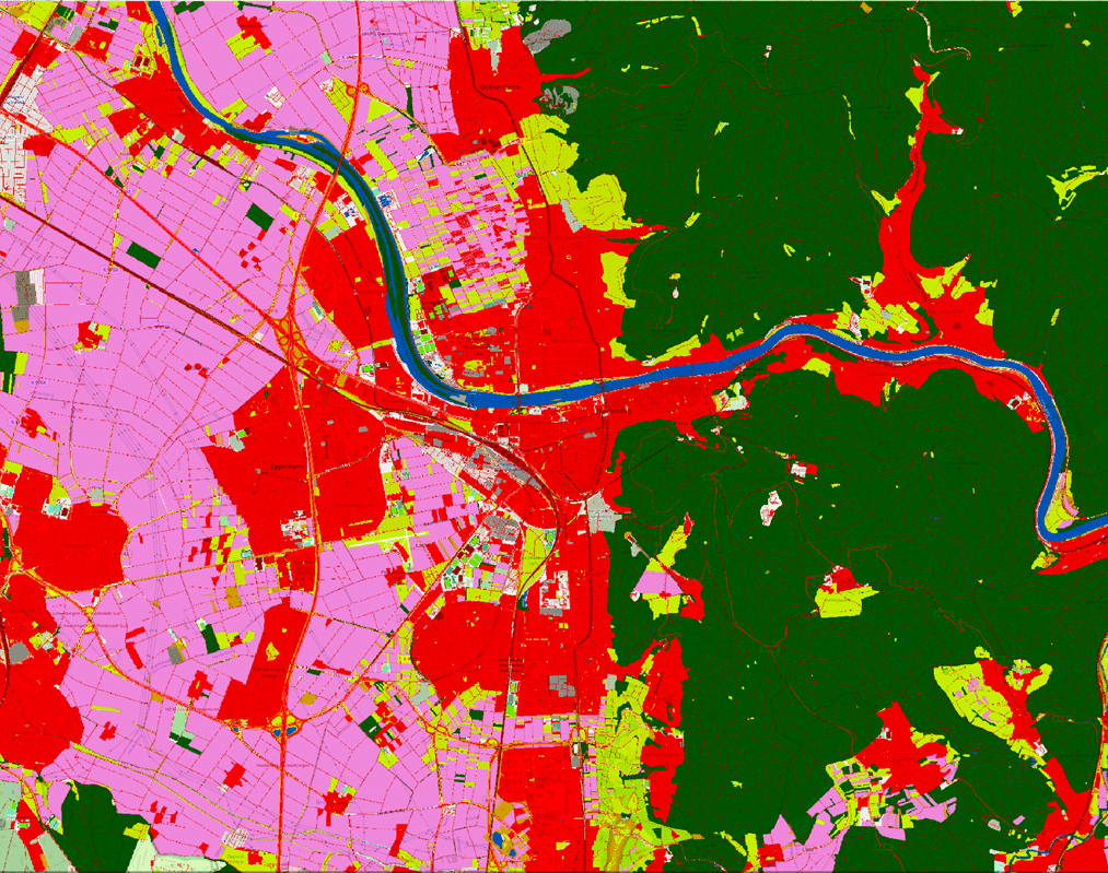
LaVerDi Project: Integrating OSM and satellite data for landscape monitoring
This project explores how OpenStreetMap data can complement satellite imagery for tracking land cover changes in Germany. Using a small test area, we compare datasets over time to better understand how real-world changes are reflected in OSM—and how this knowledge can support automated monitoring. The Federal Agency for Cartography and Geodesy (BKG) has partnered with…