

Deep learning techniques, esp. Convolutional Neural Networks (CNNs), are now widely studied for predictive analytics with remote sensing images, which can be further applied in different domains for ground object detection, population mapping, etc. These methods usually train predicting models with the supervision of a large set of training examples. However, finding ground truths especially for developing and rural areas is quite hard and manually labeling a large set of training data is costly. On the other hand Volunteered Geographic Information (VGI) (e.g., OpenStreetMap (OSM) and MapSwipe) which is the geographic data provided voluntarily by individuals, provides a free approach for such big data.
In our project “DeepVGI”, we study predictive analytics methods with remote sensing images, VGI, deep neural networks as well as other learning algorithms. It aims at deeply learning from satellite imageries with the supervision of such Volunteered Geographic Information.
VGI data from OpenStreetMap (OSM) and the mobile crowdsourcing application MapSwipe which allows volunteers to label images with buildings or roads for humanitarian aids are utilized. We develop an active learning framework with deep neural networks by incorporating both VGI data with more complete supervision knowledge. Our experiments show that DeepVGI can achieve high building detection performance for humanitarian mapping in rural African areas.
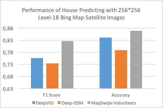
Figure 1 shows some initial results of DeepVGI, where OpenStreetMap and MapSwipe data are utilized for training together with multi-layer artificial neural networks and a VGI-based active learning strategy proposed by us. DeepVGI outperforms Deep-OSM (i.e. deep models trained with only OpenStreetMap data), and achieves close accuracy to the volunteers.
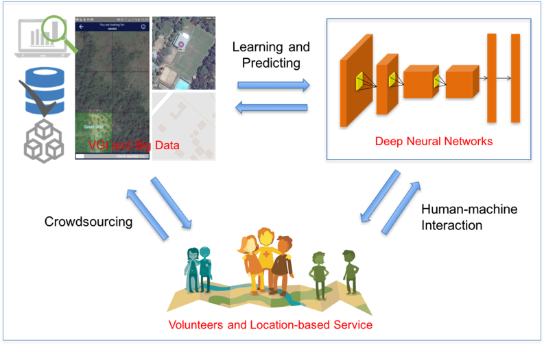
On the other hand, such predictive analytics methods will be applied in geographic applications like humanitarian mapping. It can help improve VGI data quality, save volunteers’ time, etc. DeepVGI is also an attempt to explore the interaction between human beings and machines, between crowdsourcing and deep learning. Figure 2 shows the research framework of DeepVGI project, where we will first focus on learning and prediction between deep neural networks and big spatial data (including VGI data from our history OSM project).
Further details will be made available soon. DeepVGI is a project of the HeiGIT Big Spatial Data Analytics in cooperation with the Humanitarian VGI group at HeiGIT. The Heidelberg Institute for Geoinformation Technology (HeiGIT) is currently being established with core funding by the Klaus Tschira Stiftung (KTS) Heidelberg.