Category: OSM
-

New Paper: Carbon Fluxes Related to Land Use and Land Cover Change in Baden-Württemberg
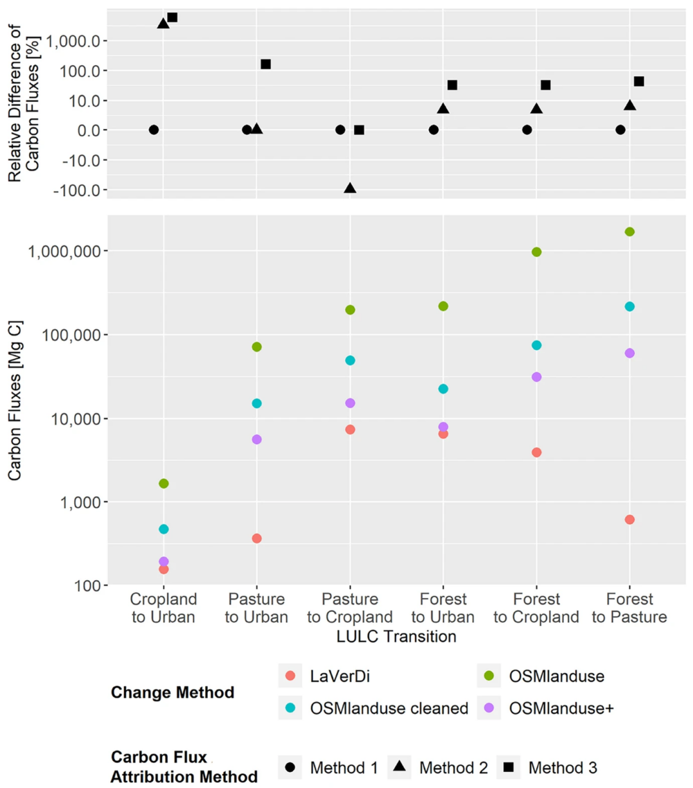
Featured Image: Figure 1. Total carbon fluxes related to LULCC in Baden-Württemberg between March 2018 and October 2019 (LaVerDi, OSMlanduse+), and March 2018 and March 2020 (OSMlanduse, OSMlanduse cleaned). The upper plot shows the relative difference of carbon fluxes [%] with respect to LULC transition and carbon flux attribution method. The carbon fluxes of method…
-
Activation of the Disaster Portal for the earthquake in Türkiye/Syria
During catastrophic events such as the recent Türkiye/Syria earthquake, the road infrastructure in the affected area is often widely interrupted and accessibility varies over time. Inspite of this, it is imperative to quickly provide assistance to the affected people. Humanitarian Organizations need real-time information for force and logistics planning: Which roads are still passable? How…
-
Disaster openrouteservice to support the current response efforts to the Türkiye/Syria earthquake
On February 6, a 7.7 magnitude earthquake struck southern Türkiye at 4:17 a.m. This is Türkiye’s most powerful earthquake recorded since 1939. The Government of Türkiye has since issued a Level 4 alarm, calling for international assistance. The quake also heavily impacted north-west Syria, a region where 4.1 million people depend on humanitarian assistance already…
-
GIScience Postdoc/Senior Researcher Opportunity for OpenStreetMap Road Quality Analysis
If you’re on the job market or know someone who is, check out this exciting new opening from our partners at GIScience. The offer is included as text below. You are interested in enhancing methods for analyzing & improving OpenStreetMap data? You are an experienced Spatial Data Scientist innovating geoinformatics methods & workflows? You have…
-
Assessing road criticality and loss of healthcare accessibility during floods: the case of Cyclone Idai, Mozambique 2019
Featured Image: Road network analysis for the driving profiles. A Normal conditions before the flood event. B Evolution of scores after the floods induced by Cyclone Idai. The lower row shows a close-up of the area surrounding the city of Dondo The ability of disaster response, preparedness, and mitigation efforts to assess the loss of physical access to health…
-
OSHDB Version 1.0 Has Arrived
Featured Photo: Ohsome dashboard interface for Heidelberg, Germany. In the words of Confucius, “The man who moves a mountain begins by carrying away small stones.” As we release OSHDB (OpenStreetMap History Database) Version 1.0, we look back at versions 0.5, 0.6, 0.7, and all the other small improvements to our historical OpenStreetMap database as the…
-
How to become ohsome part 14 – Advanced dashboarding
Hello again and welcome back to our “How to become ohsome” series where we demonstrate how you too can become ohsome with ohsome API! If you’re new to the series or need a refresher, check out the older installments in our series, like this or this one covering the various ways of accessing ohsome API. And now to our…
-
How to become ohsome part 13 – An ohsome way to check if OSM is up to date
At long last, welcome to another addition of our How to become ohsome-series! This one is special because we’re discussing a third-party application that uses ohsome API as back-end to accumulate historical OSM data. Although this innovation isn’t directly about our API, it’s close enough (and exciting enough) to merit inclusion and just one more opportunity for…
-
Open GIScience PostDoc positions on understanding the relationships between “Urban nature experience, biodiversity and mental health”
We call for applications to postdoctoral positions within the Heidelberg Mannheim Health and Life Science Alliance “Innovation Campus” for Inter-institutional project. The Central Institute of Mental Health (ZI), Prof. A. Meyer-Lindenberg, the GIScience Research Group at Heidelberg University (Prof. A. Zipf), the 3DGeo Group (Prof. B. Höfle); and the Department of Biodiversity and Plant Systematics…
-
ohsome Region of the Month: hiking-related tags & mountains
Welcome back to a new installment of the ohsome Region of the Month blog series! This will be part two our posts on hiking related tags and this time, we’ll investigate the connection between user activity and said tags. To do this, we’ll use mountain time as a reference area and incorporate insights from part one…
-
HeiGIT und Deutsches Rotes Kreuz Mapathon zur Unterstützung des Mozambique Red Cross
For english version see below HeiGIT und das Deutsche Rote Kreuz unterstützen das Mozambique Red Cross in einem Projekt zur Sensibilisierung für das Hochwasserrisiko und zum Aufbau von Kapazitäten zur Verringerung des Katastrophenrisikos in Maputo. Zur Verbesserung der Datenlage ist nun, relativ kurzfristig, ein Mapathon für kommenden Montag 23.05. ab 18 Uhr geplant. Zu Beginn…
-
Leveraging OpenStreetMap and Multimodal Remote Sensing Data with Joint Deep Learning for Wastewater Treatment Plants Detection
Humans rely on clean water for their health, well-being, and various socio-economic activities. During the past few years, the COVID-19 pandemic has been a constant reminder of about the importance of hygiene and sanitation for public health. The most common approach to securing clean water supplies for this purpose is via wastewater treatment. To date,…


