OpenStreetMap (OSM) has been intensively used to support humanitarian aid activities, especially in the Global South. Its data availability in the Global South has been greatly improved via recent humanitarian mapping campaigns. However, large rural areas are still incompletely mapped. The timely provision of map data is often essential for the work of humanitarian actors in the case of disaster preparation or disaster response. Therefore, it has become a vital challenge to boost the speed and efficiency of existing humanitarian mapping workflows. A team from the University of Heidelberg, HeiGIT and Oxford University has recently published a scientific paper that addressed this challenge.
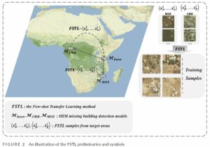
Therein, we propoed a novel few-shot transfer learning (FSTL) method to improve the accuracy of OSM missing building detection. We trained two popular object detection models (i.e., Faster R-CNN and SSD) in a training area in Tanzania and transferred the model to target areas in Cameroon and Mozambique. The FSTL method significantly improved the base model performance even with only one training shot. Moreover, we successfully produced a grid-based OSM missing building map (DeepVGI) of 10m spatial resolution with over 96\% Overall Accuracy (ACC) and 0.85 Matthews Correlation Coefficient (MCC) in both Cameroon and Mozambique. Such maps show great potential to assess and estimate the overall completeness of OSM buildings to support humanitarian mapping activities, especially in places where other (e.g., buildings, roads) datasets are not available.
In conclusion, our approach shows that it is possible to facilitate and accelerate current humanitarian mapping workflows by efficiently reusing existing ML models via few-shot learning to accurately detect OSM missing buildings in rural sub-Saharan Africa Areas.
, , , & (2022). Improving OpenStreetMap missing building detection using few-shot transfer learning in sub-Saharan Africa. Transactions in GIS, 00, 1– 22. https://doi.org/10.1111/tgis.12941
Previous related work:
- Herfort, B., Lautenbach, S., Porto de Albuquerque, J., Anderson, J., Zipf, A. (2021): The evolution of humanitarian mapping within the OpenStreetMap community. Scientific Reports 11, 3037 (2021).
- Pisl, J., Li, H., Lautenbach, S., Herfort, B., and Zipf, A. (2021): Detecting OpenStreetMap missing buildings by transferring pre-trained deep neural networks, AGILE GIScience Ser., 2, 39, https://doi.org/10.5194/agile-giss-2-39-2021.
- Geldsetzer, P.; Reinmuth, M.; O Ouma, P.; Lautenbach, S.; A Okiro, E.; Bärnighausen, T.; Zipf, A. (2020): Mapping physical access to health care for older adults in sub-Saharan Africa and implications for the COVID-19 response: a cross-sectional analysis The LANCET Healthy Longevity, Vol 1, Issue 1. https://doi.org/10.1016/S2666-7568(20)30010-6
- Li, H., Herfort, B., Huang, W., Zia, M., and Zipf, A. (2020): Exploration of OpenStreetMap Missing Built-up Areas using Twitter Hierarchical Clustering and Deep Learning in Mozambique. ISPRS Journal of Photogrammetry and Remote Sensing. https://doi.org/10.1016/j.isprsjprs.2020.05.007
- Herfort, B., Li, H., Fendrich, S., Lautenbach, S., Zipf, A. (2019): Mapping Human Settlements with Higher Accuracy and Less Volunteer Efforts by Combining Crowdsourcing and Deep Learning. Remote Sensing 11(15), 1799. https://doi.org/10.3390/rs11151799
- Li, H., Herfort, B., Zipf, A. (2019): Estimating OpenStreetMap Missing Built-up Areas using Pre-trained Deep Neural Networks. Proceedings of the 22nd AGILE Conference on Geographic Information Science, Limassol, Cyprus.
- Zipf, A, Chen, J. (2017): Humanitarian Mapping with Deep Learning and Volunteered Geographic Information. BIG 2017 (BigData Innovators Gathering). Perth. co-located with WWW2017.
- Chen, J., Y. Zhou, A. Zipf and H. Fan (2018): Deep Learning from Multiple Crowds: A Case Study of Humanitarian Mapping. IEEE Transactions on Geoscience and Remote Sensing (TGRS). 1-10. https://doi.org/10.1109/TGRS.2018.2868748
- Barron, C., Neis, P. & Zipf, A. (2013): A Comprehensive Framework for Intrinsic OpenStreetMap Quality Analysis. Transactions in GIS, DOI: 10.1111/tgis.12073.
General Overview:
- Yan, Y., C. Feng, W. Huang, H. Fan, Y. Wang & A. Zipf (2020): Volunteered geographic information research in the first decade: a narrative review of selected journal articles in GIScience. International Journal of Geographical Information Science, DOI: 10.1080/13658816.2020.1730848
- Degrossi L.C., J. Porto de Albuquerque, R. dos Santos Rocha, A. Zipf (2018): A taxonomy of quality assessment methods for volunteered and crowdsourced geographic information. Transactions in GIS (TGIS). Wiley. DOI:10.1111/tgis.12329.
- Jokar Arsanjani, J., Zipf, A., Mooney, P., Helbich, M. (Eds.)(2015): OpenStreetMap in GIScience: Experiences, Research, and Applications. Series: Lecture Notes in Geoinformation and Cartography. 2015, VII, 373 p. Sringer Science. Heidelberg, Berlin. ISBN 978-3-319-14279-1


