

The use of open-source geospatial data, exemplified by services like openrouteservice (ORS), proves to be beneficial for both academic research and use case studies. Witnessing our technologies applied in unanticipated ways showcases their potential to meet the evolving needs of various sectors while contributing positively to both society and the environment.
One exemplary application is in The World Bank project Geospatial Assessment of Women Employment and Business Opportunities in the Renewable Energy Sector, led by the Geospatial Operational Support Team (GOST, DECSC) funded by the Canada Clean Energy and Forest Climate Facility (CCEFCF). Implemented with support from Pegasys[SL1], this pioneering project aimed to introduce an innovative methodology and develop a geospatial open-source tool to map enabling environments that facilitate women’s employment opportunities within the Renewable Energy Sector across in Small Island Developing States (SIDS). The main objective centered on leveraging insights to guide new energy initiatives, aiming to enhance women’s economic empowerment and bridge employment gender disparities in the Renewable Energy (RE) sector.
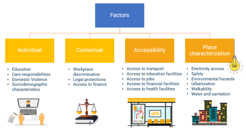
Through a multicriteria evaluation framework (MCE), the project identified 23 critical factors impacting women’s employment opportunities, categorizing them into four distinct dimensions: Individual, Contextual, Accessibility, and Place Characterization. Of these, two dimensions, Accessibility and Place Characterization, focus on geographical factors, recognizing the significance of spatial considerations in women’s job opportunities in the RE sector. In particular, Openrouteservice supported the accessibility analyses, allowing efficient assessment of routing and access. This effort culminated in the development of a comprehensive open-source spatial tool, accessible as a plugin for QGIS called GEEST (Gender Enabling Environments Tool).
GEEST’s primary strength lies in its ability to identify areas with the most favorable conditions for women’s employment in the RE sector, highlighting where targeted investments can promote gender equality. Secondly, by examining existing RE sites, it pinpoints necessary improvements to boost women’s workforce participation. Offering detailed visualizations and analyses, the tool reveals specific local deficits—such as the lack of schools, childcare, or healthcare facilities—that hinder women’s opportunities. Identifying these barriers allows strategic investments to remove obstacles and foster a more inclusive environment for women in the RE sector.
Despite the project’s success, certain limitations, such as data availability and processing time, were identified. However, GEEST demonstrates a reproducible and effective way to conduct a self-reliant, independent, and transparent mobility research on top of our open-source services and underscores the crucial role of open street data and geospatial tools in advancing research. Leveraging user-generated and collaboratively collected data from OpenStreetMap, ORS provides global spatial services, including measuring reachability and generating optimized routes. As outspoken proponents of open-source frameworks, we make all our projects available on GitHub.
We are dedicated to continuing supporting research with our services, either by providing free access to our hosted services or with guidance on how to use your infrastructure. Stay connected with us through our social media channels and blog to be abreast of future developments and releases related to ORS and advancements in geospatial technology. If you are interested in finding out what we can provide for your use-case, please check out openrouteservice.org or reach out to us in person via the channel of your choice.