

Tag: ORS
-
HeiGIT’s 5 Years Milestone: Looking Back at our Achievements
HeiGIT is celebrating its fifth anniversary today, July 1st! To commemorate this occasion, we invite you to join us on a little walk down memory lane. As we reflect on our achievements and the milestones we have reached, we want to express our deepest gratitude to the partners, projects and people that have made our…
-
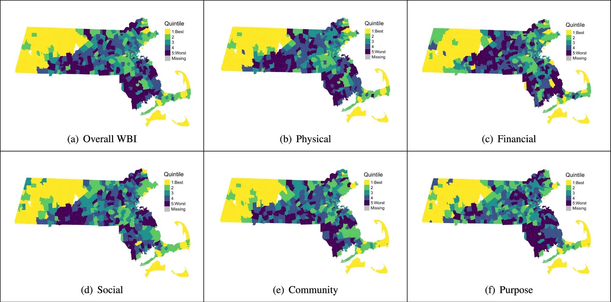
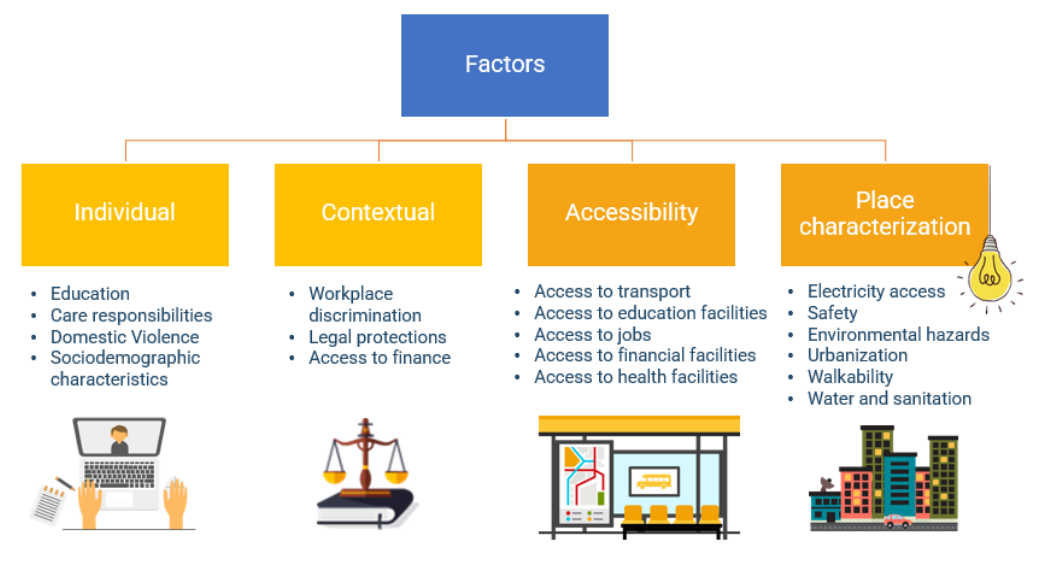
Use Case: ORS for Modeling Health and Well-Being
Open-source tools that incorporate open geospatial data, such as openrouteservice (ORS), prove to be beneficial for both academic research and practical applications. These tools enable researchers to pursue innovative approaches aimed at addressing complex societal challenges and beyond. A great illustration of this is presented in the journal paper titled “Modeling health and well-being measures…
-
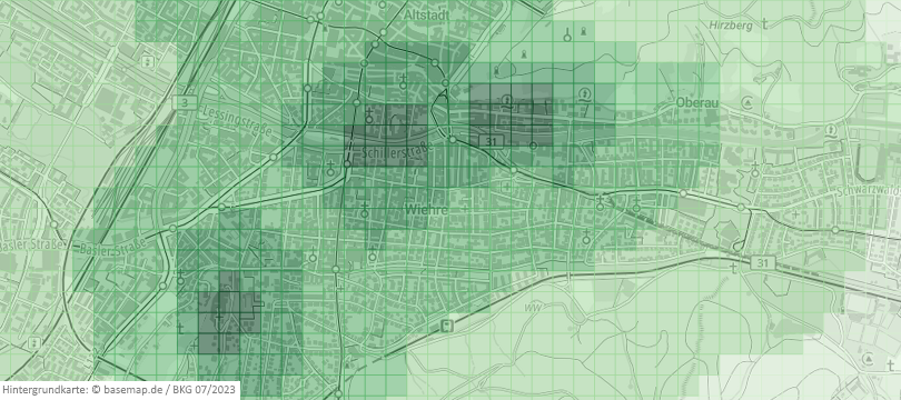
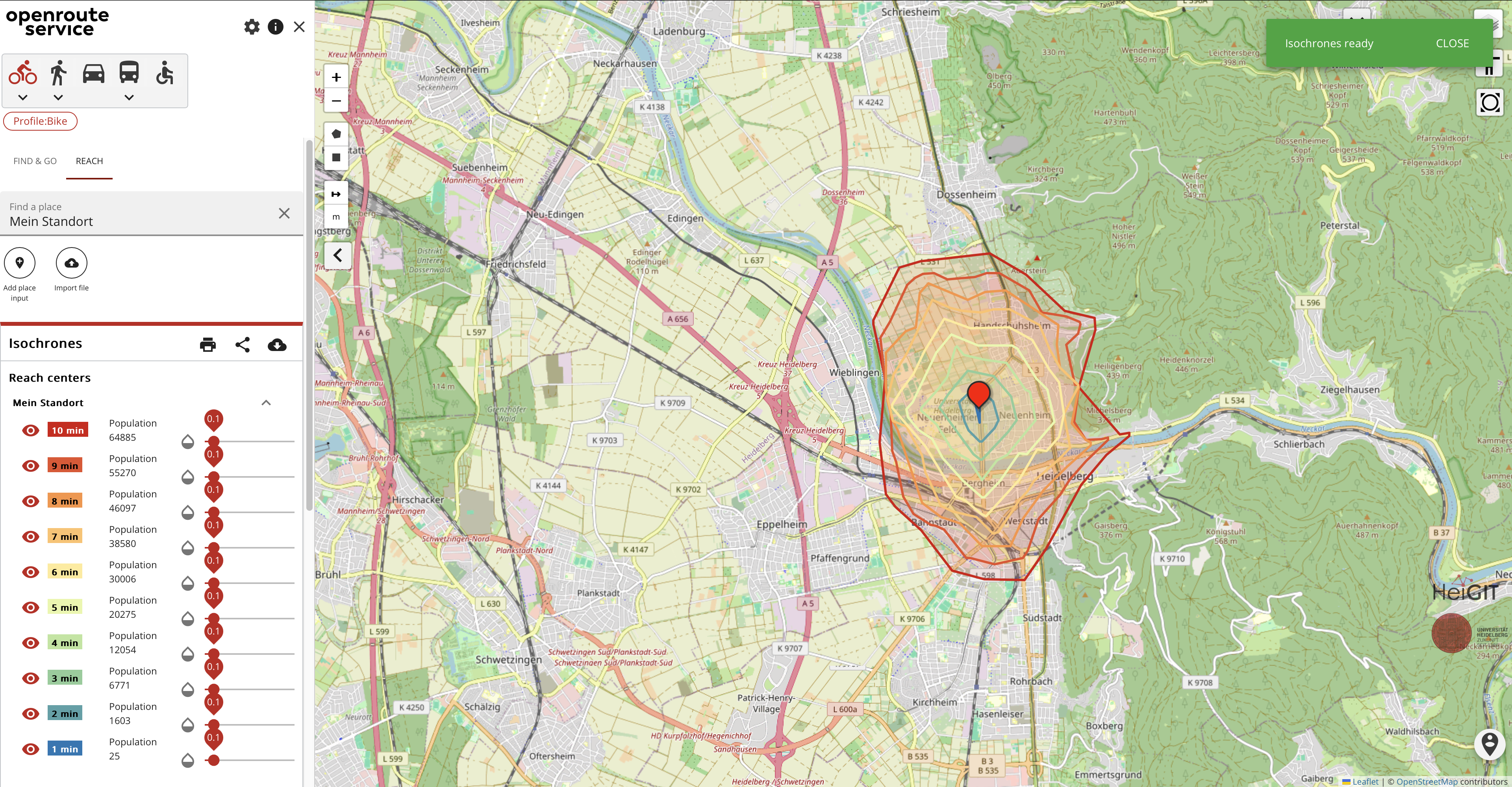
The EU-Project “Gitterzellendatenbank”: Determining Reachability Made Easy With Openrouteservice (ORS)
Free open geodata are of increasing importance. They are used in research or case studies and can lead to important insights on social, economic or environmental topics. A problem that often occurs while working with various kinds of geodata is that they cannot be used together because of differing spatial reference units. The Federal Agency…
-
Introducing openrouteservice version 8.0 — A dedication to Wilfried Juling
We’re thrilled to announce the release of openrouteservice (ors) version 8.0, designated “Wilfried”, as a tribute to Prof. Dr. Wilfried Juling, whose steady support and advice fundamentally shaped the growth and success of HeiGIT since its beginning. With countless hours and dedication poured into development and innovation, we’re excited to present a rich set of…
-
Empowering Change: OpenRouteService in Geospatial Initiatives for Women’s Economic Empowerment and Sustainable Development
The use of open-source geospatial data, exemplified by services like openrouteservice (ORS), proves to be beneficial for both academic research and use case studies. Witnessing our technologies applied in unanticipated ways showcases their potential to meet the evolving needs of various sectors while contributing positively to both society and the environment. One exemplary application is…
-

Spotlight on HeiGIT’s FOSSGIS 2024 Presentations
We’re thrilled to share some exciting news – our colleagues Julian Psotta and Benjamin Herfort are set to deliver talks at FOSSGIS 2024 in Hamburg, Germany! Julian Psotta will be presenting the openrouteservice project together with the Federal Agency for Cartography and Geodesy (BKG). Their joint talk “From openrouteservice to RoutingPlus – Insights into a…
-
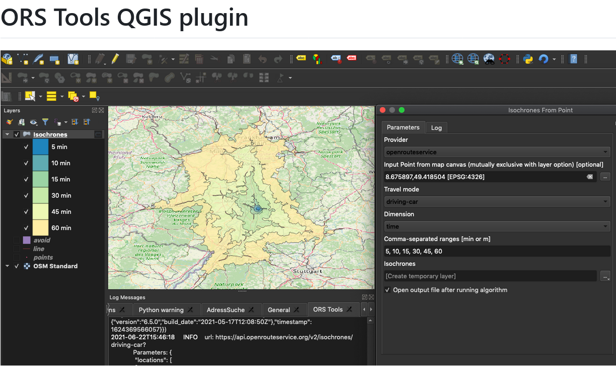
ORS Tools QGIS Plugin Release v1.7.0
Just in time for the new year, the openrouteservice team proudly announces the release of v1.7.0 of the ORS Tools QGIS plugin! Quite a lot has happened. First, the GUI was reworked: Next, there are a few other things that happened: Check out the changelog if you’re interested in all the in-depth details. Feedback and…
-
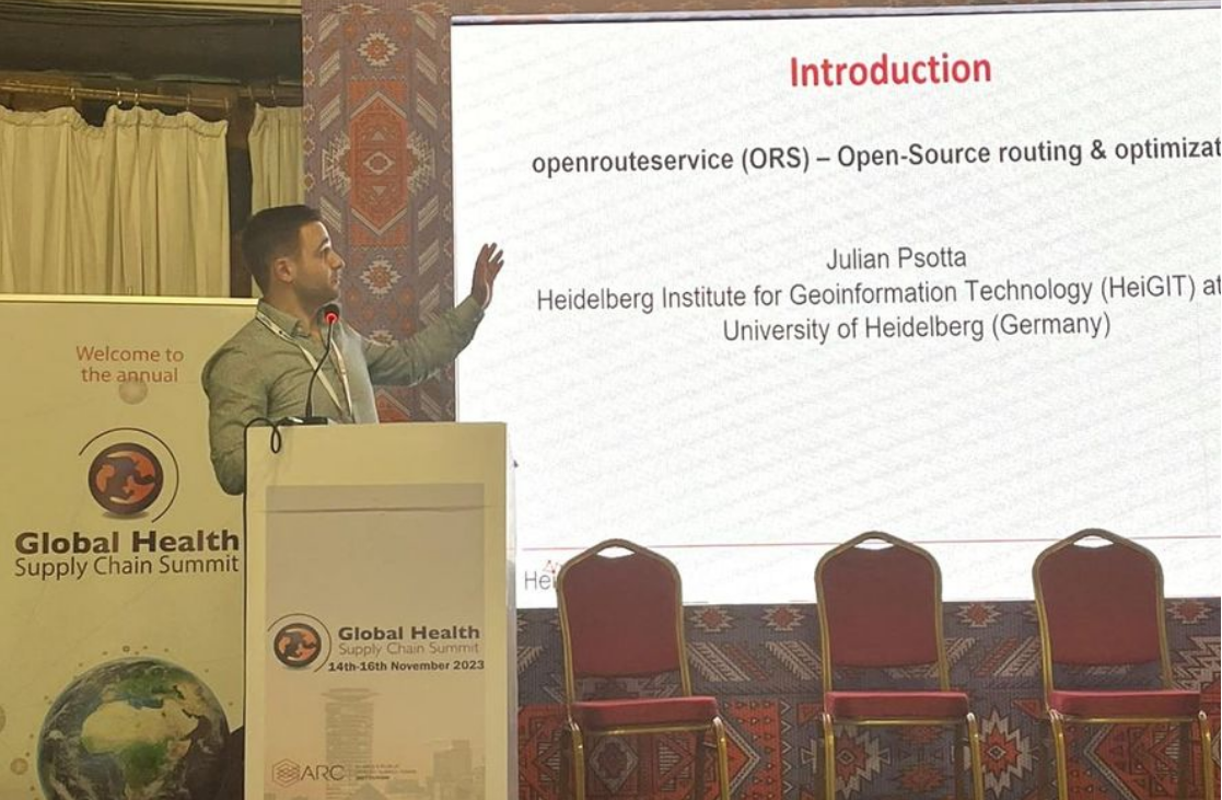
Open Source Routing and Optimization at the Global Health Supply Chain Summit 2023
HeiGIT Product Manager for Smart Mobility Julian Psotta attended this year’s Global Health Supply Chain Summit in Nairobi, Kenya. The main goal of the GHSCS 2023 was to learn and share experiences from people directly working on issues related to this year’s theme: “Sustainable and Resilient Supply Chains for Equitable Access to Healthcare”. From November…
-
HeiGITs Disaster Portal in Radiobeitrag vorgestellt
Campusreporter Nils Birschmann hat mit Prof. Alexander Zipf über unser Disaster Portal gesprochen. Das Interview wurde über Radio Regenbogen ausgestrahlt. Hier könnt ihr euch den Beitrag in voller Länge anhören: Audiobeitrag: Das Disaster Portal – sichere und schnell verfügbare Datengrundlagen im Katastrophenfall Darum geht’s: Im Katastrophenfall sind Hilfskräfte auf aktuelle Ortsdaten der betroffenen Region angewiesen: Welche…
-
Looking back at FOSS4G Conference 2023
Figure 1: FOSS4G 2023, QGIS daily openings This years FOSS4G conference took place from 26 June – 2 July 2023 in beautiful Prizren, Kosovo. Since 2006 FOSS4G, the largest global gathering for geospatial software, is organized by the Open Source Geospatial Foundation (OSGeo). This year workshops, presentations, discussions, cooperation and developing of geospatial tools and softwares…
-
Aktivierung des Disaster openrouteservice für Überschwemmungen in Pakistan
In den vergangenen Wochen hat die Monsunflut in Pakistan über 1.000 Tote gefordert und Millionen Menschen ohne Dach über dem Kopf hinterlassen. Da Berichte und Fotos von rapide steigenden Lebensmittelpreisen, Bewohnern, die durch schultertiefes Wasser waten und Satellitenbilder von überfluteten Flüssen das Ausmaß dieser Katastrophe unterstreichen, hat das HeiGIT den Disaster openrouteservice für diese Region…
-
Disaster openrouteservice response to Pakistan flooding
Over the past weeks, monsoon flooding in Pakistan has left over 1,000 dead and millions without homes. As reports and photos of skyrocketing food prices, residents wading through shoulder-deep water, and satellite images of flooded rivers highlight the magnitude of this catastrophe, HeiGIT has created an activation of the Disaster openrouteservice for that region. Currently, data is…