

Did you know that October 13th is the International Day for Disaster Risk Reduction (IDDRR)? Since 1989, the United Nations Office for Disaster Risk Reduction promotes a global culture of risk-awareness and disaster reduction on this day and encourages the community to share their events, promotions and ideas regarding disaster risk reduction. Under this year’s main theme “Fighting inequality for a resilient future”, the IDDRR highlights projects and efforts that explore the relation between inequality and disaster vulnerability. When disaster strikes, lacking access to services and resources (e.g. insurance, finances) causes a significantly worse situation in the aftermath for those who are already at a higher risk of being exposed to danger, as the recent earthquakes in Afghanistan have shown. This relation between inequality and vulnerability is only one of many factors that affect disaster risk and risk reduction.
We at the HeiGIT would like to take the IDDRR as an opportunity to introduce you to our tools and services used to aid and improve Disaster Risk Reduction as well as to provide support when disaster has already struck. We aim to distribute open geoinformation, open methods and open software in order to improve knowledge and technology transfer from fundamental research in geoinformatics to practical applications. Our tools are applicable in the fields of sustainable mobility and humanitarian aid, which are important factors in disaster risk reduction.
Openrouteservice (ORS) is a platform that offers a variety of different Geo-services, such as directions, isochrones and time distanc matrices, with a single API. It is based on user-generated and collaboratively collected free geographic data from OpenStreetMap and all of its code is opensource and freely available for all to download and contribute to on GitHub. ORS updates its data once a week.
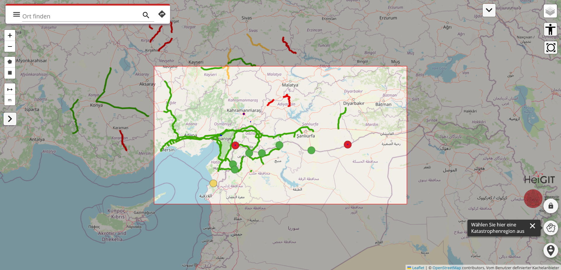
The ORS for disaster management is based on the ORS API and is similar in function. The main difference is that ORS for disaster management is limited to a set of active disaster regions which allows for much more focused data processing, enabeling updates as frequent as every ten minutes. This also applies to the Disaster Portal. In contrast to disaster ORS, the Disaster Portal has an additional function that enables users, such as relief organisatons on site of a disaster region, to update the data themselves in real time, for example by marking obstacles on the map. This feature facilitates real
Both services are used to support humanitarian action and disaster response in areas that are especially vulnerable and disaster-prone. The focus on regional data and the feature to update data individually facilitate accurate real-time desicion making. The ability to act in real-time is crucial in areas where the infrastructure as been damaged by disasters . Click here for more general information on our Disaster Portal. Here, you can learn how the Disaster Portal has helped after the earthquake in Syria and Turkiye.
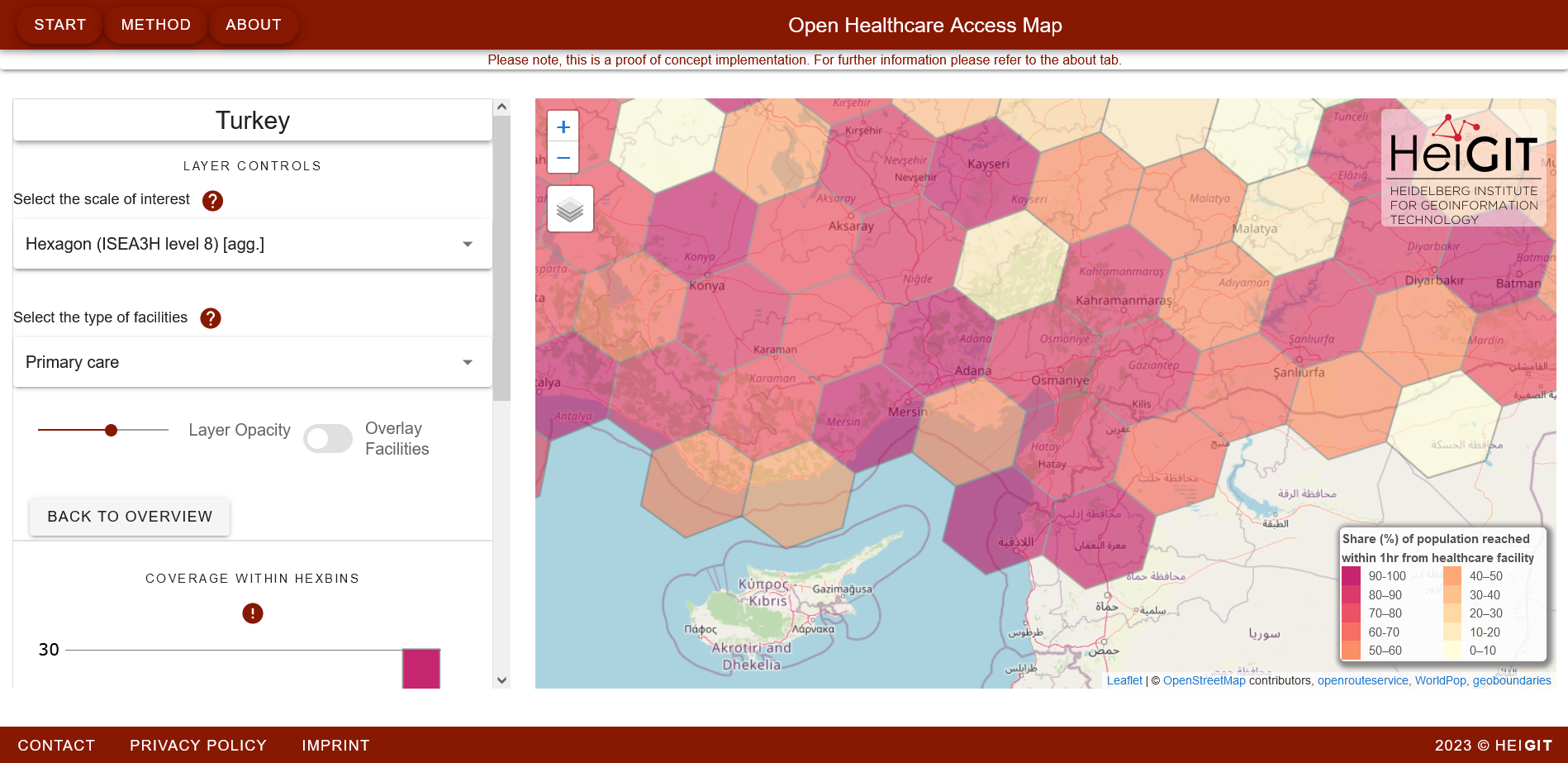
This application is a prototype to show the potential of open geodata in public healthcare. Similar to our Disaster Portal, it is also based on ORS. The application combines data on motorized mobility with data on the distribution of healthcare facilites to measure their reachability and also visualizes regional differences in healthcare distribution. The Open Healthcare Access Map could be applied in disaster situations as it facilitates the distribution of people in need of medical attention onto multiple healthcare facilites, therefore relieving individual facilities.
- Data Analysis and Optimization
Since most of our services are based on community generated data, HeiGIT researchers are frequently working on the improvement of geodata quality and availability. By pre-processing geodata and distirbuting it via services like Humanitarian OSM Stats or the ohsome-dashboard, HeiGIT enables community members to process data more efficientlym, e.g. during community mapping events. This reduces the time needed to generate more and better data, from which our services profit in turn.
In a recent publication, HeiGit associate Benjamin Herfort highlights the importance of OSM data for political and humanitarian actors and how the ohsome framework could be used to improve the available data. The relation inequalitiy and disaster vulnerability is also made evident in this publication, as data tends to be scarce on areas that would benefit the most from services based on optimal data.
If you want to learn more about the IDDRR or about HeiGIT projects concerning disaster risk reduction, check out the IDDRR news and publications page our other HeiGIT blog articles on the topic.