

Tag: time series
-
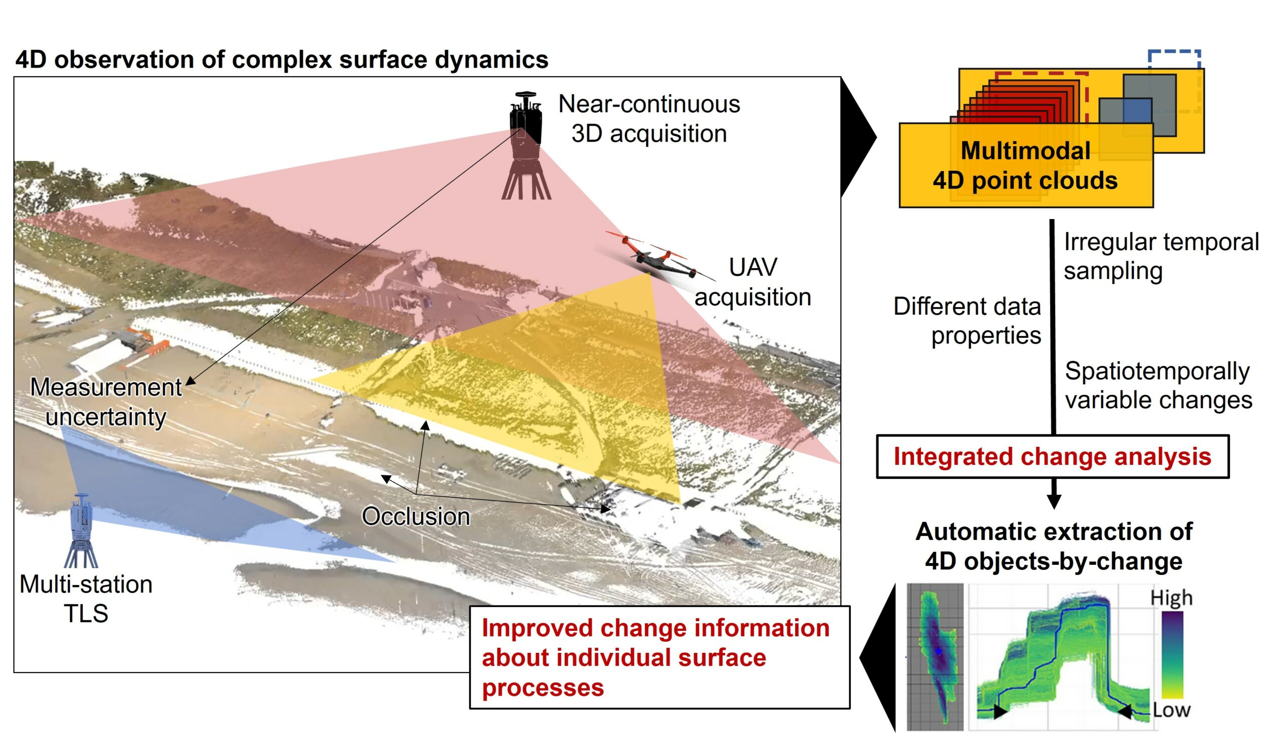
Kick-off: Extract4D Project
Last week, we, 3DGeo Heidelberg (Prof. Dr. Bernhard Höfle), had a kick-off meeting for our new joint research project Extract4D, led by Prof. Dr. Katharina Anders (TU Munich, Remote Sensing Applications). Here is a sneak peek at this exciting research project. Background The Earth’s surface is constantly being shaped by wind, water and gravity. Observing…
-
CharAct4D – Unravelling Landscape Dynamics via Automatic Characterization of Surface Activity using Geographic 4D Monitoring
With her new project CharAct4D Dr. Katharina Anders has become part of the Eliteprogramme for Postdocs of the Baden-Württemberg Stiftung, which supports early career researchers to qualify for a professorship -check the related press release by Heidelberg University. Many congratulations, Katharina! Katharina’s research interests in the 3DGeo research group are method development for 3D/4D change analysis…
-
Preview of 3DGeo @ EGU 2022 – Meet us there
The 3DGeo Research Group will present some of their latest research at EGU General Assembly 2022. We are looking forward to meet you at the following talks: Virtual Laser Scanning using HELIOS++ – Applications in Machine Learning and Forestry: The presentation provides an introduction to VLS, possible use cases, pitfalls and best practices for successful…
-
Successful PhD defense of Katharina Anders
On Tuesday, 16 November 2021, Dr Katharina Anders defended her PhD research with great success. In her dissertation, Katharina developed methods on 4D change analysis to extract natural surface changes from near-continuous LiDAR time series of dynamic landscapes. Congratulations, Katharina, for this excellent research – we are very proud to have you in our team…
-
Press release: Understanding the Spatial and Temporal Dimensions of Landscape Dynamics
The research of the 3DGeo group is featured in a press release about Understanding the Spatial and Temporal Dimensions of Landscape Dynamics. The text illustrates how Heidelberg geoinformation scientists develop new computer-based method to analyse topographic changes. The described method is published in this article: Anders, K., Winiwarter, L., Mara, H., Lindenbergh, R., Vos, S.…
-
4D change analysis for improving our understanding of dynamic landscapes
Time series of topographic point clouds offer great possibilities to advance our understanding of dynamic landscapes. To exploit the full information these 4D datasets contain on spatial and temporal properties of natural surface changes, the 3DGeo research group is developing methods for 4D change analysis. These methods are required to answer fundamental questions on the…