From 5 June – 11 June 2022 the ISPRS Congress took place in Nice, France. The 3DGeo research group had three paper contributions which can now be found online:
(1) Virtual Laser Scanning of Dynamic Scenes Created From Real 4D Topographic Point Cloud Data.
Find all details in the video (link) and paper and check the related project website.
Winiwarter, L., Anders, K., Schröder, D. & Höfle, B. (2022): Virtual Laser Scanning of Dynamic Scenes Created From Real 4D Topographic Point Cloud Data. ISPRS Annals of the Photogrammetry, Remote Sensing and Spatial Information Sciences. Vol. V-2-2022, pp. 79-86.
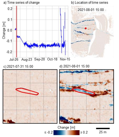
(2) Integration of Kalman Filtering of Near-Continuous Surface Change Time Series into the Extraction of 4D Objects-by-Change
Find all details in the related paper and see the 4D Objects-By-Change project website.
Anders, K., Winiwarter, L., Schröder, D. & Höfle, B. (2022): Integration of Kalman Filtering of Near-Continuous Surface Change Time Series into the Extraction of 4D Objects-by-Change. International Archives of the Photogrammetry, Remote Sensing and Spatial Information Sciences. Vol. XLIII-B2-2022, pp. 973-980.
(3) Evaluation of UAV-borne photogrammetry and UAV-borne laser scanning for 3D topographic change analysis of an active rock glacier.
Find all details in the video (link) and paper and check the related project websites of AHK-4D and Multi-Directional 3D topographic Change.
Zahs, V., Winiwarter, L., Anders, K., Bremer, M. Rutzinger, M. Potůčková, M., Höfle, B. (2022): Evaluation of UAV-borne photogrammetry and UAV-borne laser scanning for 3D topographic change analysis of an active rock glacier. International Archives of the Photogrammetry, Remote Sensing and Spatial Information Sciences. Vol. XLIII-B2-2022, pp. 1109-1116. DOI: 10.5194/isprs-archives-XLIII-B2-2022-1109-2022.