

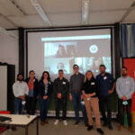
After three interesting years, the Waterproofing Data Project (WPD) comes to an end. Starting with a workshop in Brazil and several field trips, Corona times started and we had to rethink and reorganize our plans for the second half of the project. Our final workshop day in Heidelberg was also planned to be in person with colleagues from Brazil and the UK, which we had to adapt to a hybrid format. Nevertheless, we had a great workshop all together with very interesting discussions. The hybrid workshop was organized by the WPD team members Dr. Carolin Klonner and Leonie Schuchardt and took place last week on Tuesday 26th October 2021.
It was great that we had the chance to invite local stakeholders to our workshop to the Institute of Geography. The Heidelberg WPD team welcomed Andrea Caspar-Thron (fire brigade and civil protection Heidelberg), Kai Schaupp (environmental agency Heidelberg) and Sven Frenzel (water rights department Rhein-Neckar-Kreis), who are involved in urban flood risk governance to share experiences and access impacts of used and developed tools and methods. Our project partners from the UK and Brazil joined online.
The morning started with presentations, insights and videos on both the different tools and methods developed and applied in the WPD project as well as on the work of the stakeholders and the local challenges they face. In the afternoon, we discussed in person and virtually at the same time, with digital and analogue post-its about challenges, experiences and approaches to risk knowledge and communication, flood risk governance and research. We could discover a lot of similarities in challenges and approaches as well as differences especially in impacts and circumstances between Germany and Brazil.
We thank all participants for attending so actively in the workshop and we are looking forward to future collaborations.


The Waterproofing Data Project is funded by Belmont Forum and NORFACE joint programme Transformations to Sustainability (T2S) and co-funded by DLR/BMBF (Federal Ministry of Education and Research) as part of its Social-Ecological Research funding priority.
Related Work:
- Klonner, C., Hartmann, M., Dischl, R., Djami, L., Anderson, L., Raifer, M., Lima-Silva, F., Degrossi, L. C., Zipf, A., de Albuquerque, J. P. (2021). The Sketch Map Tool Facilitates the Assessment of OpenStreetMap Data for Participatory Mapping. In: ISPRS International Journal of Geo-Information 10 (3), 130. https://doi.org/10.3390/ijgi10030130
- Klonner, C., Usón, T. J., Aeschbach, N., Höfle, B. (2020). Participatory Mapping and Visualization of Local Knowledge: An Example from Eberbach, Germany. In: International Journal of Disaster Risk. https://doi.org/10.1007/s13753-020-00312-8
- Klonner, Hartmann, Djami, Zipf, A. (2019). “Ohsome” OpenStreetMap Data Evaluation: Fitness of Field Papers for Participatory Mapping. In: Minghini, M., Grinberger, A.Y., Juhász, L., Yeboah, G., Mooney, P. (Eds.). Proceedings of the Academic Track at the State of the Map 2019, 35-36. Heidelberg.