

Tag: OpenSteetMap
-
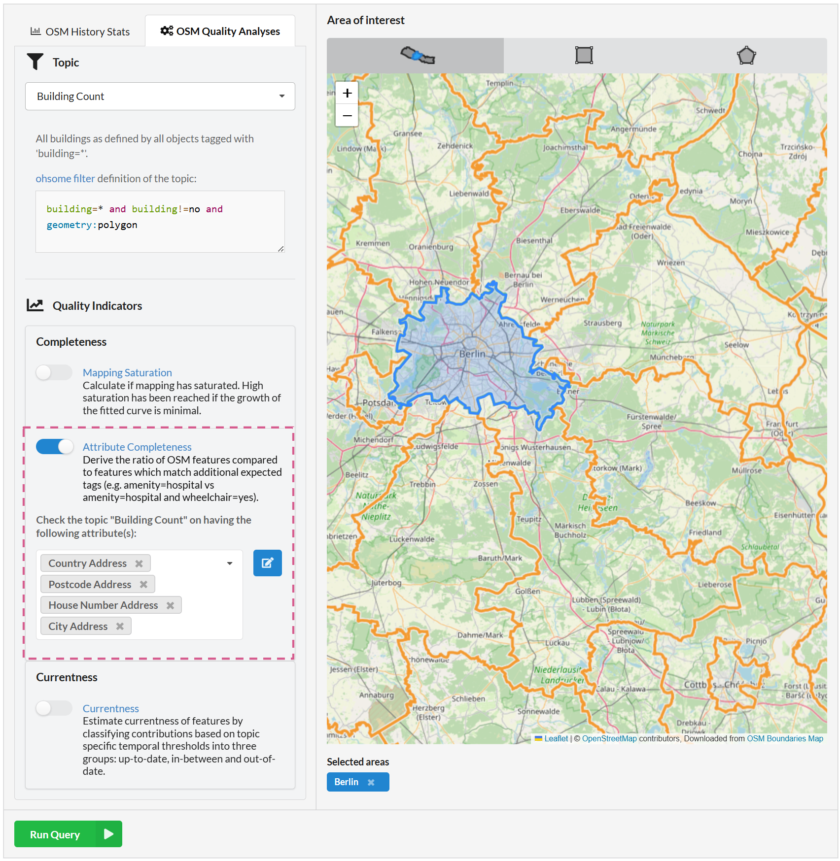
Ohsome Quality API enhancements for the attribute completeness indicator
Fig. 1: New feature: combining attributes We recently added the attribute completeness indicator to the Ohsome Dashboard, and we’re now happy to introduce major upgrades to its functionalities. The ohsome quality API (OQAPI) and the ohsome dashboard The ohsome quality API was built to provide data quality estimations for OpenStreetMap data. There are currently four…
-
How to become ohsome part 9 – More ways to access the ohsome API
At long last, welcome back to a new blog post of the “How to become ohsome“-series. As it’s been quite a while since you got an introduction to how to access the ohsome API, we would like to pick up this topic one more time this month. The former post with different ways to access the ohsome API…
-
Waterproofing Data Project: Sharing experiences and accessing impacts
After three interesting years, the Waterproofing Data Project (WPD) comes to an end. Starting with a workshop in Brazil and several field trips, Corona times started and we had to rethink and reorganize our plans for the second half of the project. Our final workshop day in Heidelberg was also planned to be in person…
-
ohsomeHeX provides access to OSM feature history
Did you ever wonder how your city was mapped over time, how geometries were changed and refined, how mistakes were added and corrected again? Then read on: ohsomeHex has a great new feature for you – the individual object’s zoom-in-history-view. To continue in providing valuable insights into the quality and development process of OpenStreetMap data, we…
-
MapAction and HeiGIT partner to further geoinformation innovation
The Heidelberg Institute for Geoinformation Technology (HeiGIT) and the international humanitarian geospatial charity MapAction have signed a Memorandum of Understanding (MoU) outlining their plans to collaborate in a number of areas. Both organisations share a common vision to support humanitarian mapping by providing innovative geoinformation services for humanitarian response, mitigating risk, anticipatory action and economic…
-
How to become ohsome part 8 – complex analysis with the magical filter parameter
It’s CITY CYCLING time – some of you may even be involved in your municipality – a good opportunity to have a look on the OpenStreetMap (OSM) cycling ways in our city Heidelberg. Welcome to part 8 of our how to become ohsome blog post series. This time we will show you how to set…
-
How to become ohsome part 7 different ways to access the ohsome API
A new month – a new post of the how to become #ohsome blog series. Welcome to part 7, in which we will show you 7 different ways how you can send a request to the ohsome API using different tools and programming languages. In case this is your first blog of how to become…
-
ohsome API 1.0 is here
As we’ve announced it in a previous post, the Open Source release 1.0 of the ohsome API has finally arrived. As a reminder, or for those of you that hear “ohsome” for the first time, the aim of the ohsome OpenStreetMap History Data Analytics Platform is to make OpenStreetMap’s full-history data more easily accessible for various kinds…
-
Invitation to GIScience colloquium talks related to Humanitarian Aid
We are happy to annouce two higly interesting upcomming presentations in the GIScience colloquium in the next weeks. Everybody interested is invited to join the presentations and the discussion afterwards. The use of geoinformatics at the German Red Cross Katharina Lorenz, DRK e.V. ‑ Generalsekretariat, Berlin Mon, January 27, 2.15 pm (Lecture Hall (room 015),…
-
Projekt “TARDUR” startet: Open-Source-Routenplanung mit zeitabhängigen Beschränkungen
Zeitabhängige Sperrungen und Nutzungsbeschränkungen von Straßen werden bislang in keiner frei verfügbaren Software zur Routenplanung genutzt. In dem im März gestarteten Projekt “TARDUR – Temporal Access Restrictions for Dynamic Ultra-Flexible Routing” gehen die Universität Heidelberg und die Firma GraphHopper dieses Problem an. Das Projekt wird im Rahmen der Förderrichtlinie Modernitätsfonds (“mFUND”) mit insgesamt 100.000 Euro…
-
CfP: Transactions in GIS special issue on “Open Source Geospatial Science, Software and Education”
Special issue information: The last decade has seen a rapid growth in open source geospatial software and data developments. Open geospatial data applies the principles of free and openness to geospatial information, allowing communities to collaborate on a data product. Applying the lessons learned in the open source industry to geo-data collection and maintenance has…
-
Accessibility analysis of public transport in Stuttgart
The Statistical Office of the City of Stuttgart determined the walking time to the nearest public transport stop for every place in the city using our QGIS plugin OSM Tools. With OSM Tools it only takes a few mouse clicks to access most of the functions of the openrouteservice. The toolset includes routing, isochrones and…