

These days so much is different- also conferences. Carolin Klonner and Marcel Reinmuth attended the GeOnG 2020 virtually. Thanks to the organizers!
It worked well and there was great exchange between the participants. The workshop on experiences in defining health catchment areas brought together diverse stakeholders and approaches. Marcel Reinmuth contributed from the scientific open technology perspective to the workshop. He shared his latest findings on travel time to health facilities in Sub-Saharan Africa.
The lightning talk “OpenStreetMap Sketch Map Tool – The Future of OpenStreetMap Field Papers” presented by Carolin Klonner shows a new participatory mapping method to visualize and formalize local knowledge and is available online.
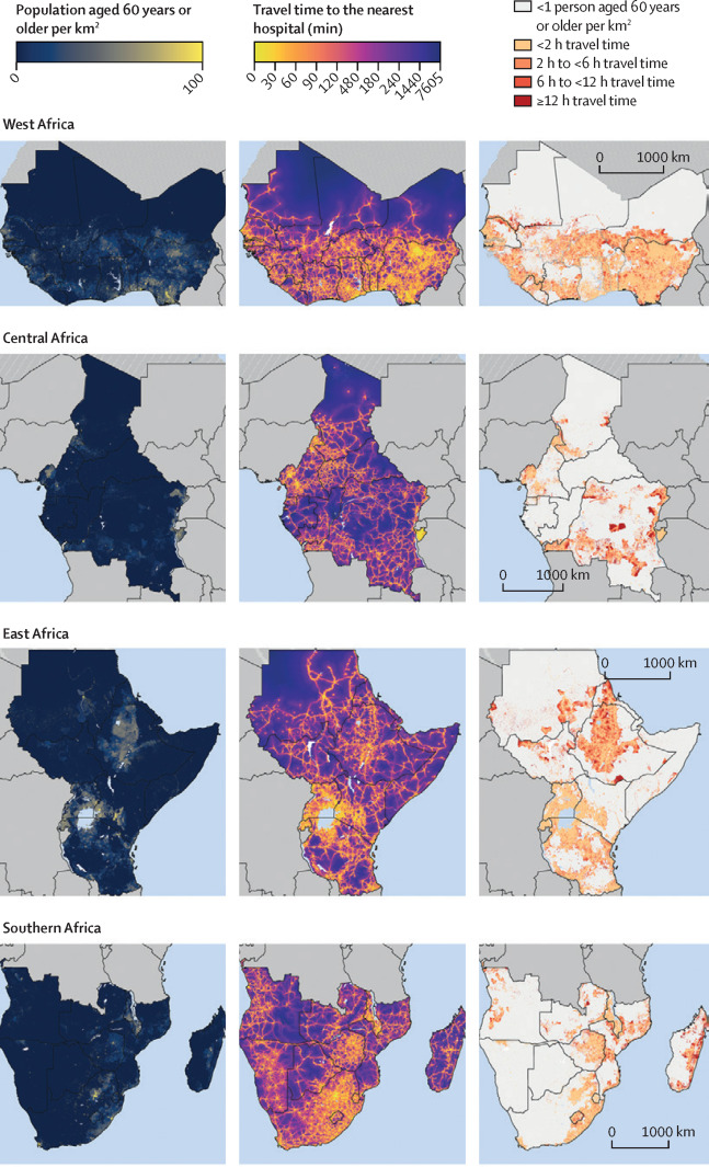
Geldsetzer, P.; Reinmuth, M.; O Ouma, P.; Lautenbach, S.; A Okiro, E.; Bärnighausen, T.; Zipf, A. (2020): Mapping physical access to health care for older adults in sub-Saharan Africa and implications for the COVID-19 response: a cross-sectional analysis https://doi.org/10.1016/S2666-7568(20)30010-6
Klonner, Hartmann, Djami, Zipf, A. (2019). “Ohsome” OpenStreetMap Data Evaluation: Fitness of Field Papers for Participatory Mapping In: Minghini, M., Grinberger, A.Y., Juhász, L., Yeboah, G., Mooney, P. (Eds.). Proceedings of the Academic Track at the State of the Map 2019, 35-36. Heidelberg.
Related work
- Exploring OSM for healthcare acccess analysis in Sub-Saharan Africa
- Analysing OSM Completeness of health facilities in Sub-Sahara Africa in ohsomeHeX
- Exploring OSM history: the example of health related amenities
- Tools for Disaster Risk Reduction by HeiGIT – Celebrating the International Day for Disaster Risk Reduction