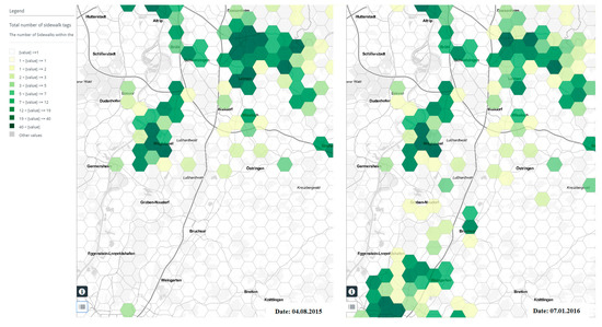
Using data generated from the crowd has become a hot topic for several application domains including transportation. However, there are concerns regarding the quality of such datasets. As one of the most important crowdsourced mapping platforms, in a recent study (1) we analyze the fitness for use of OpenStreetMap (OSM) database for routing and navigation of people with limited mobility. See (2) for background information. The completeness of OSM data is being assessed regarding sidewalk information. Relevant attributes for sidewalk information such as sidewalk width, incline, surface texture, etc. are considered, and through both extrinsic and intrinsic quality analysis methods (3), the results of fitness for use of OSM data for routing services of disabled persons are presented. Based on that empirical results, it is concluded that OSM data of relatively large spatial extents inside the studied cities could be an acceptable region of interest to test and evaluate wheelchair routing and navigation services, as long as other data quality parameters such as positional accuracy and logical consistency are checked and proved to be acceptable. We present an extended version of OSMatrix web service (4) and explore how it is employed to perform spatial and temporal analysis of sidewalk data completeness in OSM. The tool is beneficial for piloting activities, whereas the pilot site planners can query OpenStreetMap and visualize the degree of sidewalk data availability in a certain region of interest. This would allow identifying the areas that data are mostly missing and plan for data collection events. Furthermore, empirical results of data completeness for several OSM data indicators and their potential relation to sidewalk data completeness are presented and discussed.

(1) Mobasheri, A.; Sun, Y.; Loos, L.; Ali, A.L (2017): Are Crowdsourced Datasets Suitable for Specialized Routing Services? Case Study of OpenStreetMap for Routing of People with Limited Mobility. Sustainability 2017, 9(6), 997; doi:10.3390/su9060997
(2) Zipf, A.; Mobasheri, A.; Rousell, A.; Hahmann, S. (2016): Crowdsourcing for individual needs—The case of routing and navigation for mobility-impaired persons. In European Handbook of Crowdsourced Geographic Information; Capineri, C., Haklay, M., Huang, H., Antoniou, V., Kettunen, J., Ostermann, F., Puves, R., Eds.; Ubiquity Press: London, UK, 2016; pp. 325–337
(3) Barron, C., Neis, P. & Zipf, A. (2013): A Comprehensive Framework for Intrinsic OpenStreetMap Quality Analysis , Transactions in GIS, Volume 18, Issue 6, December 2014, Pages: 877–895 DOI: 10.1111/tgis.12073.
(4) Roick, O., Loos, L. & Zipf, A. (2012): Visualizing spatio-temporal quality metrics of Volunteered Geographic Information – A case study for OpenStreetMap. Geoinformatik 2012. Mobilität und Umwelt. Braunschweig. Germany.
OSM Wheelchair Routing for Europe at https://OpenRouteService.org
ORS with Open Spaces Pedrestrian Routing: https://Labs.OpenRouteService.org
OSMatrix for Europe: http://osmatrix.uni-hd.de


