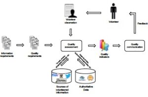
Volunteered Geographic Information (VGI) has emerged as a potential source of geographic information for different domains. Despite the many advantages associated with it, such information lacks of quality assurance, since it is provided by individuals with different motivations and backgrounds. In response to this, several methods have been proposed to assess the quality of volunteered geographic information of different platforms. However, there has been little investigation aimed at explaining how cross-platform data could be used for quality assessment. Moreover, it is not clear how the volunteer could be inserted in the quality assessment process in order to improve the overall quality. In a recent paper, we propose a conceptual model to assess the quality of volunteered geographic information for the purpose of flood management that combines cross-platform data, i.e. OpenStreetMap and social media data, and authoritative data. This model is part of an ongoing research for the development of an approach for quality assessment of VGI in a flood citizen observatory.
Degrossi, L., Porto, A., Fan, H., Zipf, A. (2016): A conceptual model for quality assessment of VGI for the purpose of flood management. Link-VGI LINKing and analyzing Volunteered Geographic Information (VGI) across different platforms, Workshop at 19th AGILE International Conference on Geographic Information Science 2016. Helsinki.


