

Tag: HumanitarianOSMStats
-
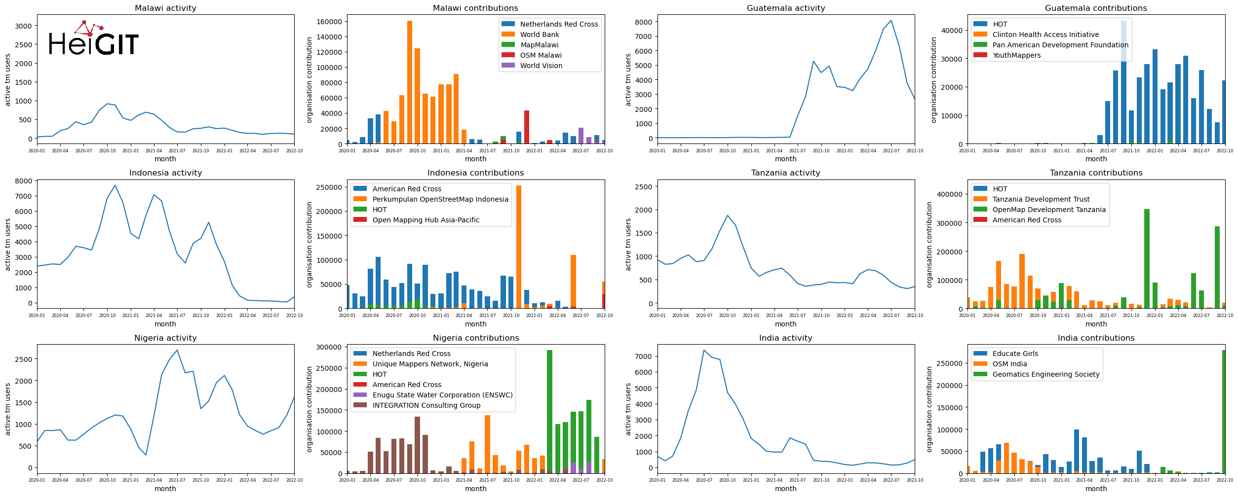
Analysis of Humanitarian OSM Stats: User activity through HOT-TM and contributing organizations
Introduction In this blogpost we are taking a look at humanitarian mapping through the Tasking Manager (HOT-TM) that is operated by the Humanitarian OpenStreetMap Team (HOT). At HeiGIT we work together with HOT to provide analyses and statistics to further understand mapping activity. Explore the user and mapping stats of all Tasking Manager activites here. Check our blog posts about topics…
-
OSM Changeset Analysis with Humstats and the ohsome Framework
In this blog post we want to take a closer look at a fruitful mapping collaboration between humanitarian organizations and corporations. Since 2015 mapping remote areas in OSM is one part in the cooperation between the leading savings, retirement and insurance company, Aviva, and the British Red Cross (BRC). By combining multiple datasets we analyzed…
-
Monitoring OSM and Tasking Manager to Map 1 Billion
In 2020, the Humanitarian OpenStreetMap Team (HOT) received funding from seven donors through TED’s Audacious Project. This has accelerated HOT’s ambition to map an area home to one billion people. HOT is working to add places at high risk of natural disaster or experiencing poverty to OpenStreetMap by significantly scaling-up support for local mapping communities.…
-
Humanitarian OSM Stats: How to monitor humanitarian mapping in the HOT Tasking Manager? – Part 5: the American Red Cross
Since 2010 organized humanitarian mapping has evolved as a constant and growing element of the global OpenStreetMap (OSM) community. With more than 8,000 projects in 150 countries humanitarian mapping has become a global community effort. Due to this large amount of projects, it can be difficult to get an overview on mapping activity. This is…
-
Humanitarian OSM Stats: How to monitor humanitarian mapping in the HOT Tasking Manager? – Part 4
Since 2010, organized humanitarian mapping has evolved as a constant and growing element of the global OpenStreetMap (OSM) community. With more than 7,000 projects in 150 countries, humanitarian mapping has become a global community effort. Due to this large amount of projects, it can be difficult to get an overview on mapping activity. This is…
-
Humanitarian OSM Stats: How to monitor humanitarian mapping in the HOT Tasking Manager? – Part 3
Since 2010 organized humanitarian mapping has evolved as a constant and growing element of the global OpenStreetMap (OSM) community. With more than 7,000 projects in 150 countries humanitarian mapping has become a global community effort. Due to this large amount of projects, it can be difficult to get an overview on mapping activity. This is…
-
The evolution of humanitarian mapping within the OpenStreetMap community
In the past 10 years, the collaborative maps of OpenStreetMap (OSM) have been used to support humanitarian efforts around the world as well as to fill important data gaps for implementing major development frameworks such as the Sustainable Development Goals (SDGs). In a recently accepted paper we provide a comprehensive assessment of the evolution of…
-
Humanitarian OSM Stats: How to monitor humanitarian mapping in the HOT Tasking Manager? – Part 2
Since 2010 organized humanitarian mapping has evolved as a constant and growing element of the global OpenStreetMap (OSM) community. With more than 7,000 projects in 150 countries humanitarian mapping has become a global community effort. Due to this large amount of projects it can be difficult to get an overview on mapping activity. This is…
-
Humanitarian OSM Stats: How to monitor humanitarian mapping in the HOT Tasking Manager? – Part 1
Since 2010 organized humanitarian mapping has evolved as a constant and growing element of the global OpenStreetMap (OSM) community. With more than 7,000 projects in 150 countries humanitarian mapping has become a global community effort. Due to this large amount of projects it can be difficult to get an overview on mapping activity. This is…
-
Introducing the humstats.heigit.org dashboard about Humanitarian Mapping in OpenStreetMap
Since 2010 organized humanitarian mapping has evolved as a constant and growing element of the global OpenStreetMap (OSM) community. With more than 7,000 projects in 150 countries humanitarian mapping has become a global community effort. Mappers have added more than 60 Million buildings to OSM through HOT’s Tasking Manager. That’s around 13% of all OSM…