

Search results for: “public health”
-
New Jupyter Notebook: Analysis of Access to Health Care using openrouteservice Isochrones API
What is the idea behind the Notebook? In the case of an emergency (e.g. floods, earthquakes, political crisis) it is important to know where the health facilities are located. Furthermore, it is important to identify which cities/districts have a reduced or no access at all to health facilities before an emergency. Many countries still posses…
-
Recent changes to OpenStreetMap healthcare infrastructure in India
India accounts for nearly 18% of the worlds population. The country is also one of the main carrier of the worlds disease burden. Despite the general increase in life expectancy and decreasing mortality due to communicable diseases and malnutrition in recent years, the numbers of non-communicable diseases are rising substantially. Cardiovascular diseases such as diabetes and…
-
Mapping physical access to health care for older adults in sub-Saharan Africa and implications for the COVID-19 response: a cross-sectional analysis
New paper published on healthcare access in Sub-Saharan Africa It is almost a year since SARS-CoV-2 first emerged in China. The virus spread all over the world. Countries south of the Sahara did not receive much attention. Although outbreaks here have a strong risk potential due to existing crises. In our new published paper we…
-
Exploring OSM for healthcare access analysis in Sub-Saharan Africa
[tl;dr] Using hospital locations and the ORS Isochrone service, we have created a method for comparing physical access to healthcare in Sub-Saharan Africa. Hospital locations were derived from OpenStreetMap and compared against another free available dataset. Results indicate strong similarity in both hospital datasets, however the uncertainty of our method requires further evaluation. Figure 1…
-
Analysing OSM Completeness of health facilities in Sub-Sahara Africa in ohsomeHeX
A new map in ohsomeHeX provides an overview of areas in Sub-Sahara Africa where information on health facilities is still missing in OpenStreetMap (OSM). The completeness of OSM is measured by comparing to a reference dataset on public health facilities in Sub-Sahara Africa, which was developed by Maina et al. 2019. Especially in these days,…
-
Green spaces in cities promote well-being and mental health — ‘Nature’ Neuroscience study published with participation of GIScience researchers at Heidelberg University
INTERDISCIPLINARY NATURE STUDY SHOWS THAT INNER TOWN GREEN DIRECTLY INFLUENCES ON CITY RESIDENTS Inner city green areas such as lawns, flowerbeds, trees or parks can directly improve the well-being of city dwellers. These are the findings of a recent study conducted by scientists from GIScience Research Group at Heidelberg University and the Heidelberg Institute for…
-
Introducing Healthy Routing preferring Green Areas with OpenRouteService
Research in psychology and public health shows that there are environmental factors that cause an area to impose more or less stress to a person. One example is that being surrounded by natural green areas (meadows, parks, trees and forests etc. or also blue water areas) has a relaxing influence to the mood of a…
-
This Wednesday Talks on Travel Impedance and Dynamics of Health-Related Tweets by Prof. Eric Delmelle
The semester has come to an end but still we are happy to invite you this to two open colloquium talks by Dr. Eric Delmelle, Associate Professor, Department of Geography & Earth Sciences, University North Carolina Charlotte about the two interesting topics: “Evaluating Travel Impedance Agreement among Online Road Network Data Providers” & “Visualizing the…
-
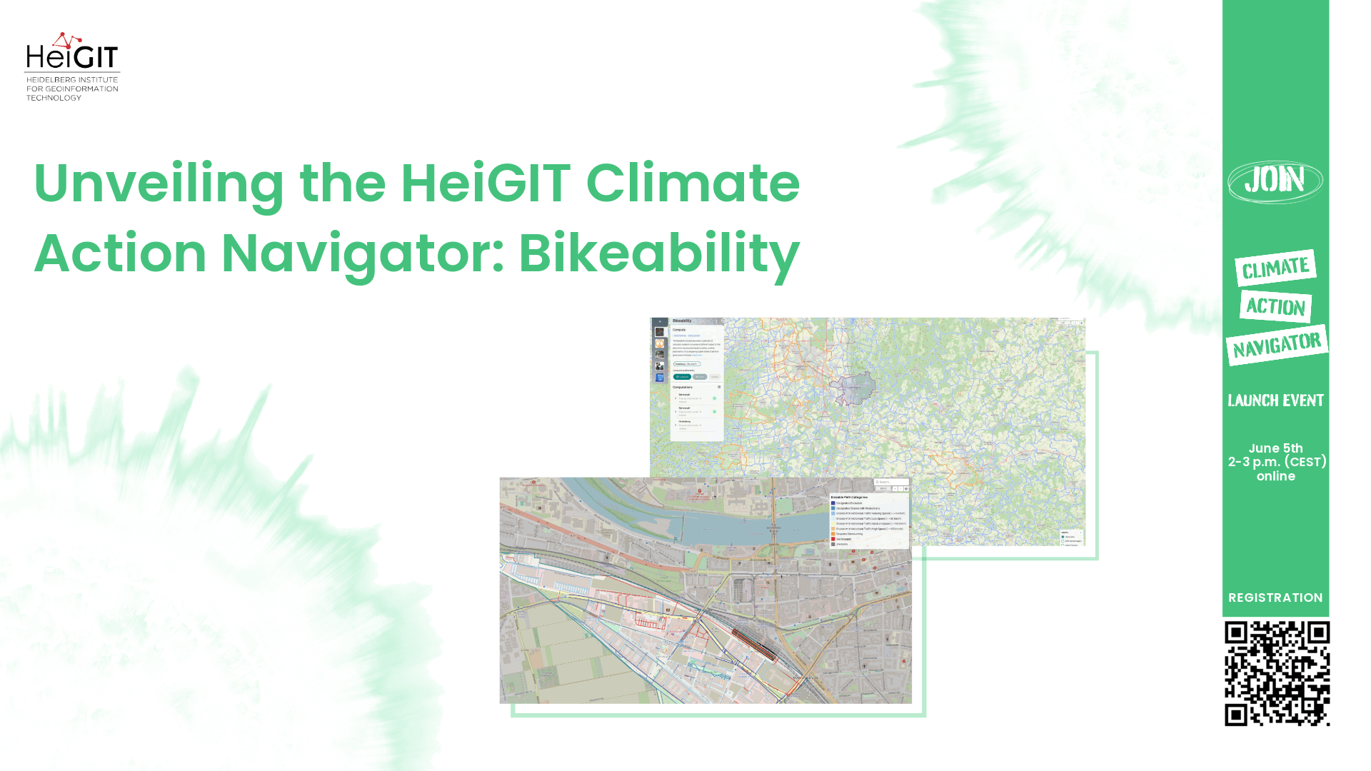
Unveiling the HeiGIT Climate Action Navigator Part 2 – Bikeability (hiBike)
In just 15 days, on May 15th, we will officially launch the Climate Action Navigator (CAN): HeiGIT’s new dashboard offering high-resolution, open data-based insights into key climate action indicators. From assessing CO2 emissions from residential heating to urban active mobility infrastructure, CAN helps identify where targeted action is most urgently needed. In this second post…
-
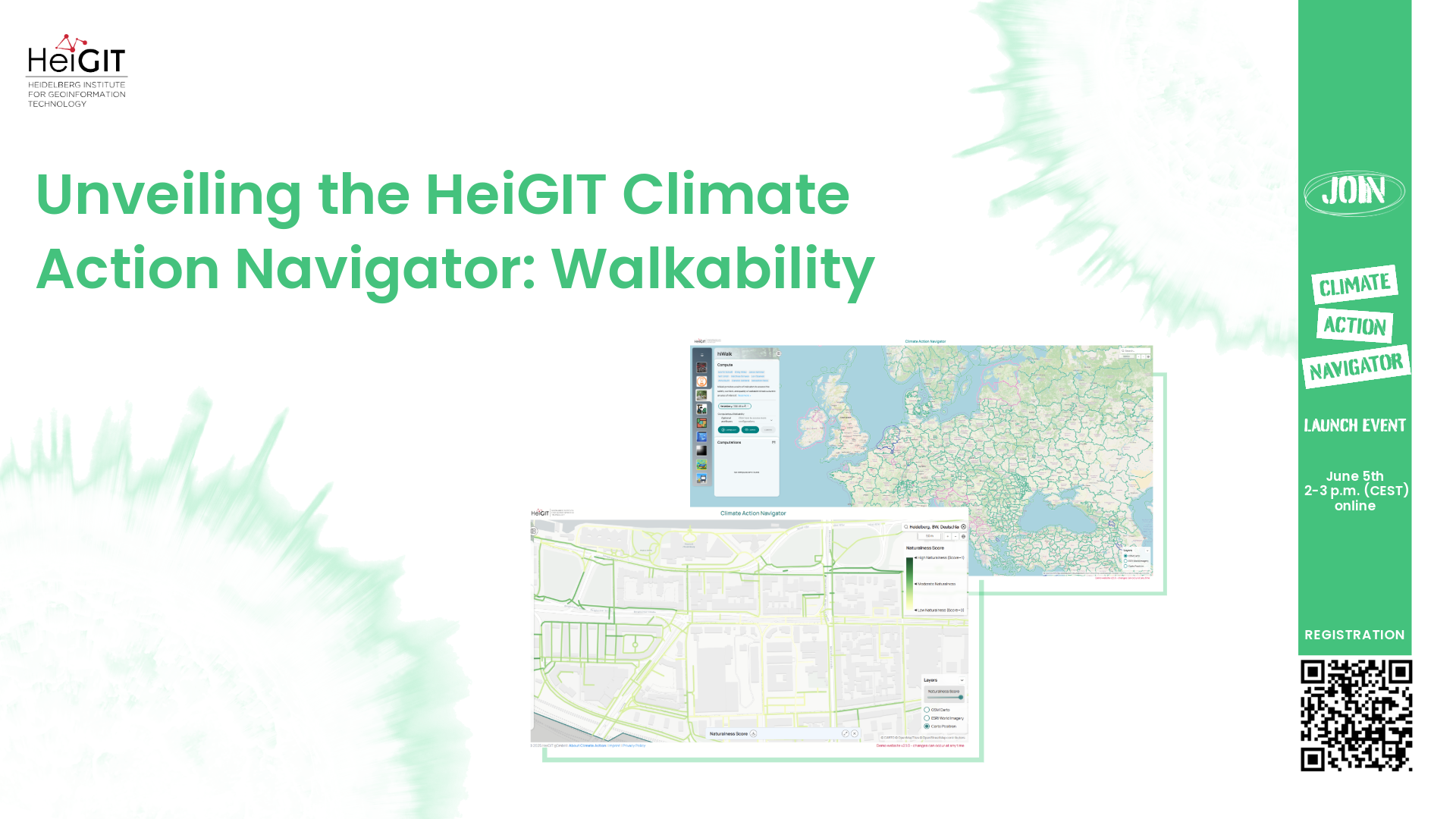
Unveiling the HeiGIT Climate Action Navigator Part 1 – Walkability
In just 22 days, on May 15th, we will officially launch the Climate Action Navigator (CAN): HeiGIT’s new dashboard offering high-resolution, open data-based insights into key climate action indicators. From assessing CO2 emissions from residential heating to urban active mobility infrastructure, CAN helps to identify where targeted action is most urgently needed. In this first…
-
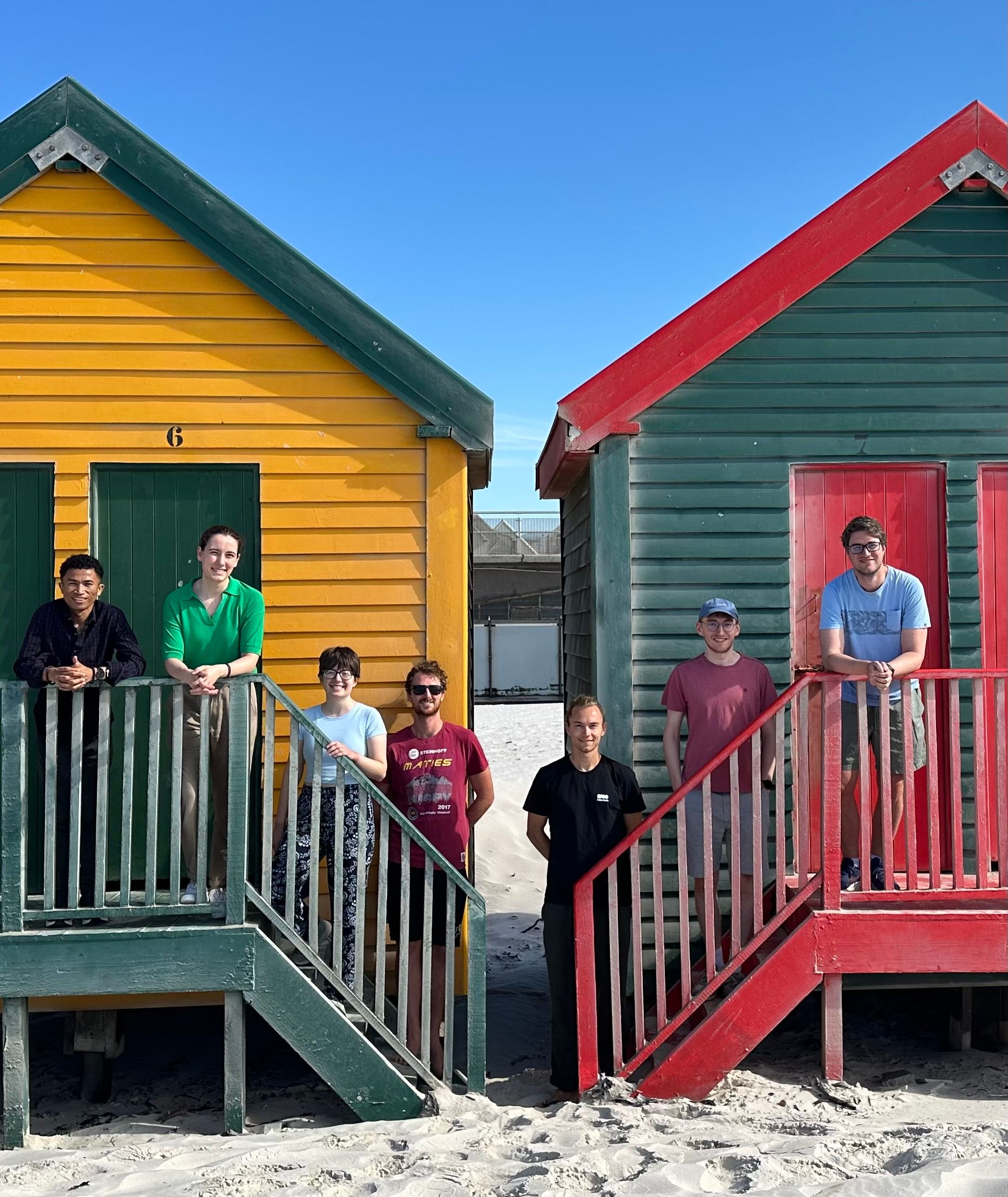
Post-doctoral Research Visit at African Institute of Mathematical Sciences (AIMS) in Cape Town
From January to March 2025, Dr. Steffen Knoblauch undertook a post-doctoral research visit at the African Institute of Mathematical Sciences (AIMS) in Cape Town, South Africa. His research focused on integrating Earth Observation data with bioacoustics, building on his PhD work in spatiotemporal mosquito monitoring for diseases such as Dengue. The primary focus of his…
-
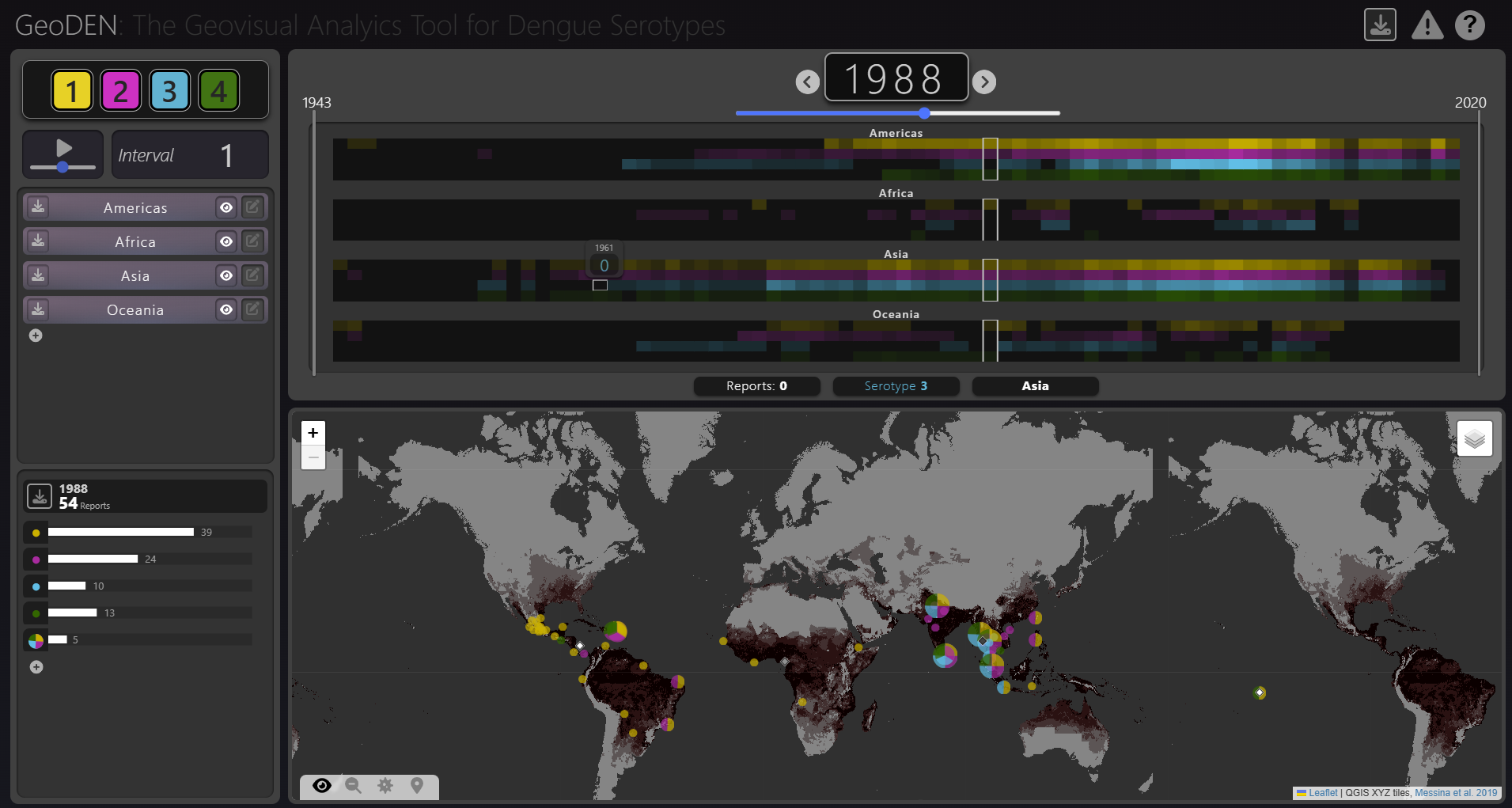
New Paper “GeoDEN: A Visual Exploration Tool for Analyzing the Geographic Spread of Dengue Serotypes”
With the increasing availability of global disease datasets, Visual Analytics (VA) has emerged as a valuable tool in spatial epidemiology, particularly for studying serotype interactions in diseases like dengue. Dengue, caused by four serotypes (DENV1-DENV4), poses a significant global health threat exacerbated by urbanization and climate change. Traditional approaches rely on static mapping or animation…