

Category: Traffic
-

Announcing openrouteservice version 9.0.0: codename “Europa”
We are proud to announce the release of openrouteservice version 9.0.0, codename “Europa”. In this release, there are a number of new features that make running your own instance a whole lot easier, and some changes that improve the general routing results. For our API users, this release will not mean much, as just a…
-
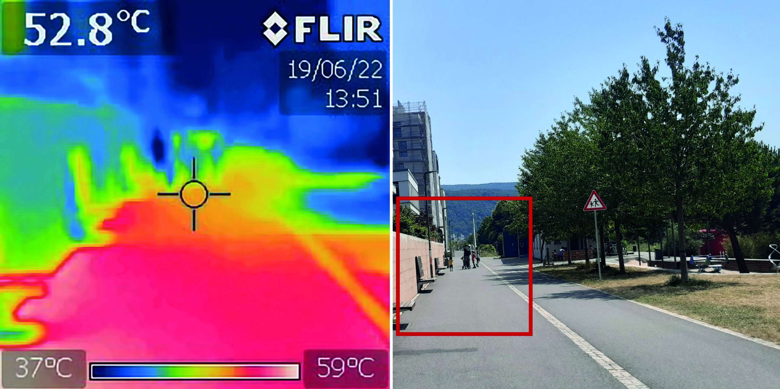
“How to assess the needs of vulnerable population groups towards heat-sensitive routing?”
The research team of the transdisciplinary project HEAL (Heat Adaptation for Vulnerable Population Groups), focusing on providing heat adaptation measures for vulnerable groups in Heidelberg, has published a research paper titled “How to assess the needs of vulnerable population groups towards heat-sensitive routing? An evidence-based and practical approach to reducing urban heat stress”. The paper…
-
Introducing openrouteservice version 8.0 — A dedication to Wilfried Juling
We’re thrilled to announce the release of openrouteservice (ors) version 8.0, designated “Wilfried”, as a tribute to Prof. Dr. Wilfried Juling, whose steady support and advice fundamentally shaped the growth and success of HeiGIT since its beginning. With countless hours and dedication poured into development and innovation, we’re excited to present a rich set of…
-
Unveiling the Impact of School Commutes: Charles Hatfield Presents Insights on Traffic Congestion and Urban Planning at ATRC 2024
Charles Hatfield will represent HeiGIT at the first ever African Transport Research Conference (ATRC 2024) which takes place from March 5-7 in Capetown, South Afrika. The conference was established to address rapid urbanisation in Africa and the corresponding challenges for transport and infrastructure. Volvo Research and Educational Foundations (VREF) and the Centre for Transport Studies…
-
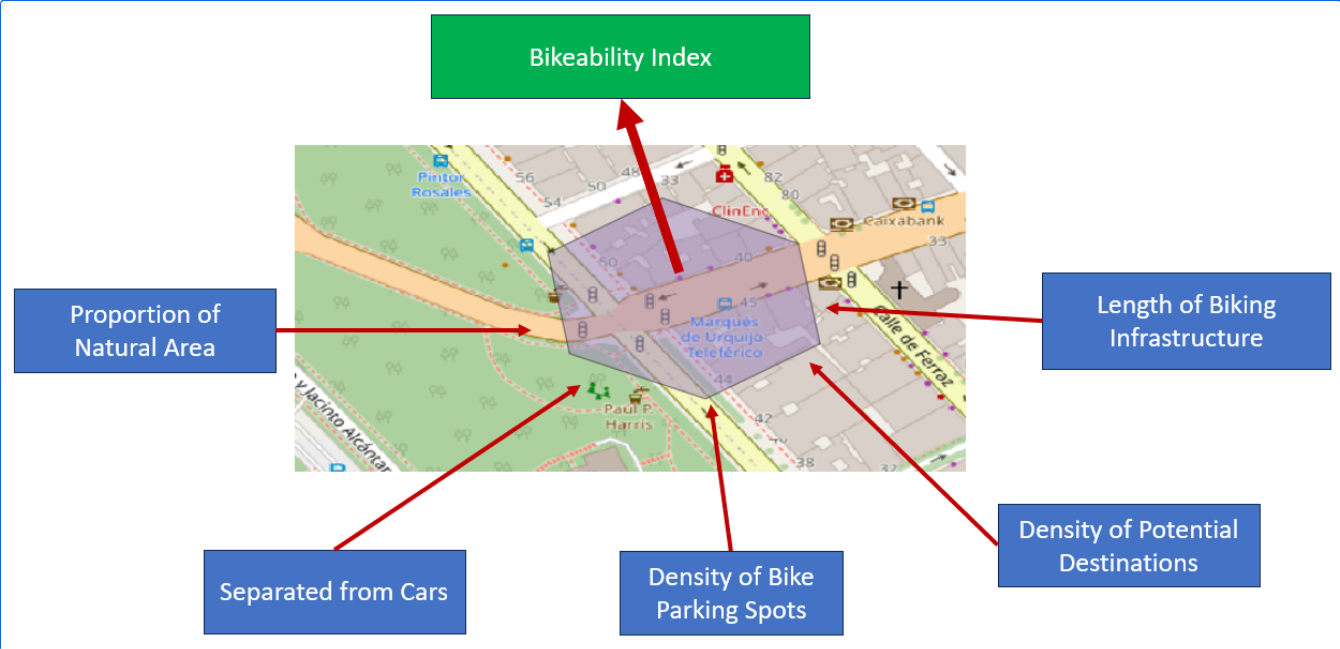
Analyzing Bikeability
For various reasons biking is becoming a more frequently used mode of transportation. It offers flexibility, is quite cheap compared to other modes of transportation, helps with fitness and is almost carbon neutral. To evaluate how well adapted the existing infrastructure is to accommodate biking, Manuel Kraft of HeiGIT created the “Bikeability-Index”. Analyzing Bikeability There…
-
Assessing road criticality and loss of healthcare accessibility during floods: the case of Cyclone Idai, Mozambique 2019
Featured Image: Road network analysis for the driving profiles. A Normal conditions before the flood event. B Evolution of scores after the floods induced by Cyclone Idai. The lower row shows a close-up of the area surrounding the city of Dondo The ability of disaster response, preparedness, and mitigation efforts to assess the loss of physical access to health…
-
Understanding spatiotemporal trip purposes of urban micro-mobility from the lens of dockless e-scooter sharing
Over the last two years, we have witnessed the ever-fast growth of micro-mobility services (e.g., e-bikes and e-scooters), which brings both challenges and innovations to the traditional urban transportation systems. For example, they provide an opportunity to better address the “last mile” problem due to their convenience, flexibility and zero emission. As such, it is…
-
Join our final “SocialMedia2Traffic” project presentation on March 22
Navigation services need time dependent information on traffic speed to generate suitable routes and yield accurate travel time estimations. However, this information is not available free of cost globally. Within the recently completed project “SocialMedia2Traffic”, we have developed a system to model traffic speed of urban roads depending on the time of day based on…
-
WENN ES IN DER STADT ZU HEISS WIRD
Aktuelle Meldung der Universität Heidelberg zum Projekt HEAL: https://www.uni-heidelberg.de/de/newsroom/wenn-es-in-der-stadt-zu-heiss-wird BADEN-WÜRTTEMBERG STIFTUNG FÖRDERT HEIDELBERGER PROJEKT ZU ROUTINGDIENST MIT HITZEVERMEIDENDEN WEGSTRECKEN Wo in der Stadt Heidelberg ist es besonders heiß und wie wirken sich lokale Hitzebelastungen auf gefährdete Personengruppen aus? Mit dieser Frage befasst sich ein Forschungsprojekt, durchgeführt von der Abteilung Geoinformatik und dem TdLab Geographie am Geographischen…
-
Kick-off workshop for the research program “Innovation for adaptation to climate change” by Baden-Württemberg Stiftung
The project HEAL (HeiGIT, GIScience, TdLab Geographie) is funded by the Baden-Württemberg Stiftung as part of the research program “Innovation for adaptation to climate change“. HEAL aims at an extension of the openrouteservice to allow the generation of heat avoiding routes, using Heidelberg as a test case. The project aims specifically at vulnerable groups such…