

Author: Moritz Schott
-
OEV: Indicator Correlations (4/4)
After introducing the OSM Element Vectorisation Tool last week, we now want to show possible use cases and specific examples of what the tool can do. This third and last example will look at the correlations between indicators. The goal is to first assure that the indicators measure distinct data attributes and then search for interesting or…
-
OEV: Quantifying differences between imports (3/4)
After introducing the OSM Element Vectorisation Tool last week, we now want to show possible use cases and specific examples of what the tool can do. This second of three use cases (see use case 1) compares the data in the regions of Maribor, Slovenia and Ngaoundéré, Cameroon. Both regions are exceptionally well covered with land-use and land-cover information in OSM.…
-
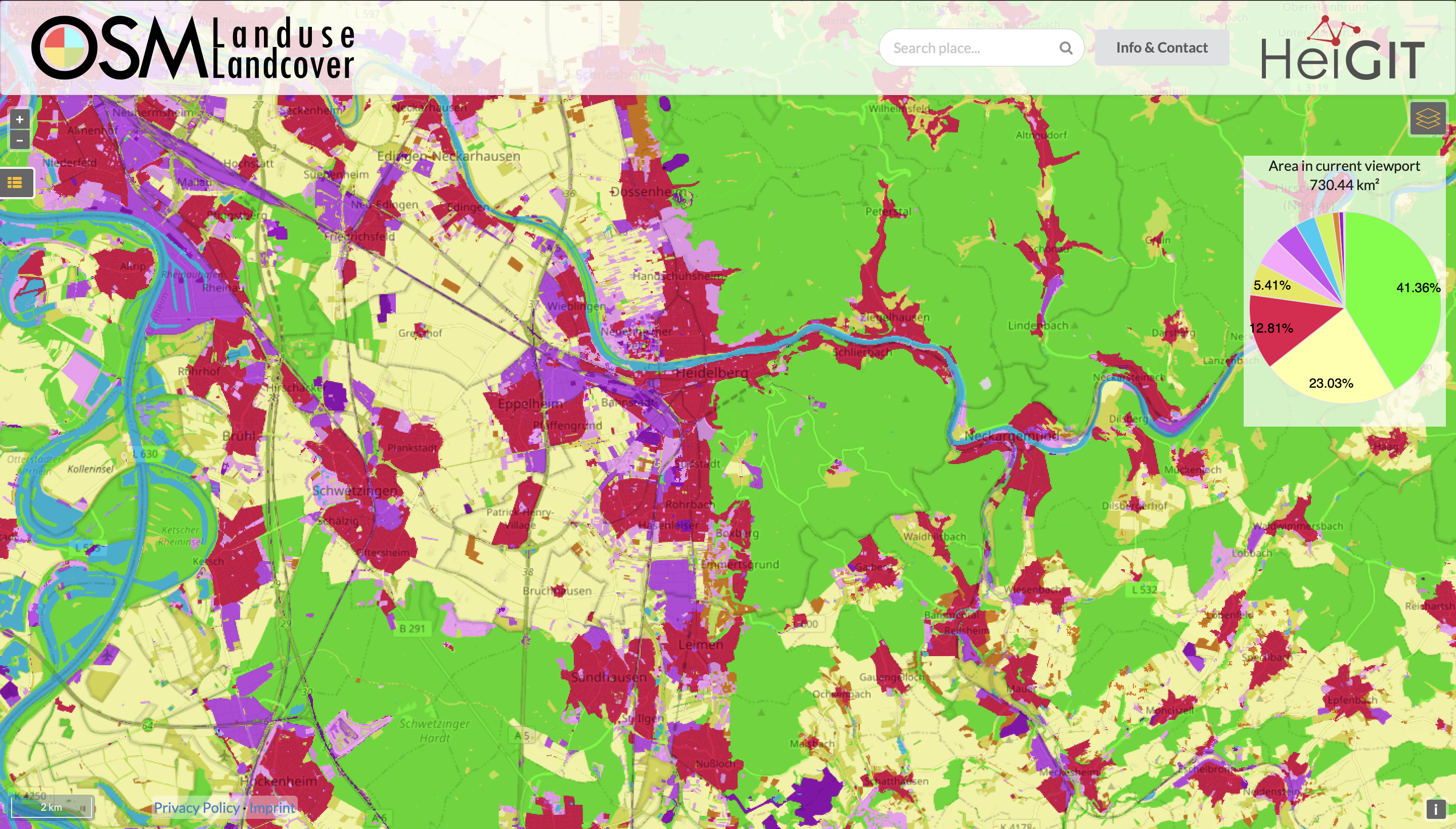
Functionality Update for OSM Landuse Landcover
We are pleased to announce that https://osmlanduse.org has received a functionality update. Thanks to the cooperation of GIScience and HeiGIT under the IDEAL-VGI project, our researchers were able to add a number of new features to the interactive map. The map displays OSM land-use and land-cover information. The two different data layers that made up…
-
High Resolution Data Insights from OpenStreetMap Element Vectorisation
One of the contributions showcased by the HeiGIT/GeoScience team in last year’s Free and Open Source Software for Geospatial (FOSS4G) 2022 conference in Florence (Italy) was Moritz Schott, Sven Lautenbach, Leonie Großchen, and Alexander Zipf’s novel paper “OpenStreetMap Element Vectorisation: A Tool for High Resolution Data Insights and its Usability in the Land-use and Land-cover…
-
Integrating Bird Observations from Community Projects and Social Media
Environmental developments create an ever increasing need for monitoring and protection measures. These efforts are often based on digital or technical solutions like data analyses or modelling. Yet, in order to enable effective, reliable and large scale environmental monitoring and protection techniques, large information volumes are required. In a recently published paper, we analyse different…
-
A basic guide to OSM data filtering
Working with OpenStreetMap data is an exciting topic that often reveals astonishing insights. The free and open nature of the project allows a plethora of analyses topics. We at HeiGIT often concentrate on global quantitative analyses and visualisations powered by the ohsome framework. But our tools also enable you to gain more detailed, multifaceted or…
-
New publication on the Impact of Community Happenings in OpenStreetMap
Online knowledge projects such as OpenStreetMap (OSM) and Wikipedia have gained high importance, trust and even economic value. These projects and their content are maintained and enhanced by online communities that evolve around them. Yet, these communities and their members are often ignored when the respective data or knowledge is used. In a recent publication…
-
The future of working with OSM data
The open, flexible and collaborative nature as well as the benefits and advantages of OpenStreetMap (OSM) lead to the creation of a whole new ecosystem evolving around the project. They range from local and global communities of data and software developers to a large amount of tools and services like disaster response, routing, art etc.…