Training in Innovative Technologies for Close-range Sensing in Alpine Terrain – 3rd Edition
The 3rd edition of the international summer school “Close-range Sensing Techniques in Alpine terrain” took place in Obergurgl, Austria, in June 2019. A group of 40 young researchers (mainly PhD students) participated to learn about various sensors, processing techniques, and analysis methods for different topics in high-mountain research.
A recently published article reports on results from the training and seminar activities and the outcome of student questionnaire survey. Comparison between the recent edition and the past edition in 2017 shows no significant differences on the level of satisfaction on organizational and training aspects. Gender balance was present both in candidates and in the outcome of selections. Selection was based on past research activities and on topic relevance. The majority of trainees were therefore doctoral candidates and postdoctoral researchers, but also motivated master students participated. The training took place through keynotes, lectures, seminars, in the field with hands-on surveys followed by data analysis in the lab, and teamwork for preparing a final team presentation over different assignments.
Find all details in the full article:
Rutzinger, M., Anders, K., Bremer, M., Höfle, B., Lindenbergh, R., Oude Elberink, S., Pirotti, F., Scaioni, M., and Zieher, T.: TRAINING IN INNOVATIVE TECHNOLOGIES FOR CLOSE-RANGE SENSING IN ALPINE TERRAIN – 3RD EDITION, Int. Arch. Photogramm. Remote Sens. Spatial Inf. Sci., XLIII-B5-2020, 243–250, https://doi.org/10.5194/isprs-archives-XLIII-B5-2020-243-2020, 2020.
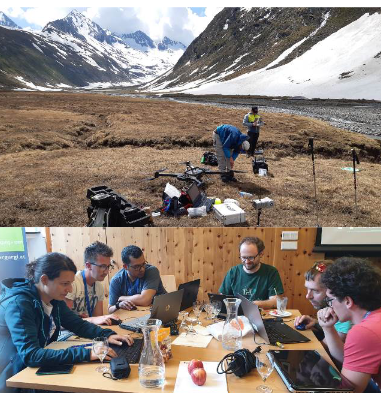
For assignments all sensors and platforms had to be carried to the field site of interest (top), sensors on hand-held, terrestrial and UAV-platforms have been studied (top) and finally data has been processed and analysed by participants (bottom).
See also recent research articles based on assignments of participants of the summer school 2019 below:
Backes, D., Smigaj, M., Schimka, M., Zahs, V., Grznárová, A., and Scaioni, M.: RIVER MORPHOLOGY MONITORING OF A SMALL-SCALE ALPINE RIVERBED USING DRONE PHOTOGRAMMETRY AND LIDAR, Int. Arch. Photogramm. Remote Sens. Spatial Inf. Sci., XLIII-B2-2020, 1017–1024, https://doi.org/10.5194/isprs-archives-XLIII-B2-2020-1017-2020, 2020.
Karantanellis, E., Arav, R., Dille, A., Lippl, S., Marsy, G., Torresani, L., and Oude Elberink, S.: EVALUATING THE QUALITY OF PHOTOGRAMMETRIC POINT-CLOUDS IN CHALLENGING GEO-ENVIRONMENTS – A CASE STUDY IN AN ALPINE VALLEY, Int. Arch. Photogramm. Remote Sens. Spatial Inf. Sci., XLIII-B2-2020, 1099–1105, https://doi.org/10.5194/isprs-archives-XLIII-B2-2020-1099-2020, 2020.
Interested in participating in the next summer school in 2021? Stay tuned for updates and find some more impressions on the summer schools in 2015, 2017 and 2019.
The summer school organizing committee wants to thank all the sponsors, which are the Faculty of Geo- and Atmospheric Sciences and the Vice Rector for Research of the University of Innsbruck, University of Padova, and the Copernicus Academy. We further thank all keynote speakers, all supportive administrative staff from the University of Innsbruck and staff at the University Centre Obergurgl for hosting the event. We further thank the University of Innsbruck for funding data organisation and publication via Open Educational Data for Environmental Monitoring (OEDEM) and the ISPRS Education and Capacity Building Initiative for funding the online education project Spreading out the Knowledge from ISPRS Educational Events using a Dissemination Internet Platform (SKIEE-DIP).