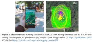
User-generated map data is increasingly used by the technology industry for background mapping, navigation and beyond. An example is the integration of OpenStreetMap (OSM) data in widely-used smartphone and web applications, such as Pokémon GO (PGO), a popular augmented reality smartphone game. As a result of OSM’s increased popularity, the worldwide audience that uses OSM through external applications is directly exposed to malicious edits which represent cartographic vandalism. Multiple reports of obscene and anti-semitic vandalism in OSM have surfaced in popular media over the years. These negative news related to cartographic vandalism undermine the credibility of collaboratively generated maps. Similarly, commercial map providers (e.g., Google Maps and Waze) are also prone to carto-vandalism through their crowdsourcing mechanism that they may use to keep their map products up-to-date. Using PGO as an example, this research analyzes harmful edits in OSM that originate from PGO players. More specifically, a recently published paper analyzes the spatial, temporal and semantic characteristics of PGO carto-vandalism and discusses how the mapping community handles it. Our findings indicate that most harmful edits are quickly discovered and that the community becomes faster at detecting and fixing these harmful edits over time. Gaming related carto-vandalism in OSM was found to be a short-term, sporadic activity by individuals, whereas the task of fixing vandalism is persistently pursued by a dedicated user group within the OSM community. The characteristics of carto-vandalism identified in this research can be used to improve vandalism detection systems in the future.
Juhász, L.; Novack, T.; Hochmair, H.H.; Qiao, S. Cartographic Vandalism in the Era of Location-Based Games—The Case of OpenStreetMap and Pokémon GO. ISPRS Int. J. Geo-Inf. 2020, 9, 197.
Earlier work:
Neis, P., Goetz, M. & Zipf, A. (2012): Towards Automatic Vandalism Detection in OpenStreetMap. ISPRS International Journal of Geo-Information. Vol.1(3), pp.315-332. DOI:10.3390/ijgi1030315.
Neis, P. & Zipf, A. (2012): Analyzing the Contributor Activity of a Volunteered Geographic Information Project – The Case of OpenStreetMap. ISPRS International Journal of Geo-Information. Vol.1(2), pp.146-165. MDPI. DOI:10.3390/ijgi1020146 .
Barron, C., Neis, P. & Zipf, A. (2013): A Comprehensive Framework for Intrinsic OpenStreetMap Quality Analysis. Transactions in GIS, DOI: 10.1111/tgis.12073.
General Overview
Yan, Y., C. Feng, W. Huang, H. Fan, Y. Wang & A. Zipf (2020): Volunteered geographic information research in the first decade: a narrative review of selected journal articles in GIScience. International Journal of Geographical Information Science, DOI: 10.1080/13658816.2020.1730848
Degrossi L.C., J. Porto de Albuquerque, R. dos Santos Rocha, A. Zipf (2018): A taxonomy of quality assessment methods for volunteered and crowdsourced geographic information. Transactions in GIS (TGIS). Wiley. DOI:10.1111/tgis.12329.
Jokar Arsanjani, J., Zipf, A., Mooney, P., Helbich, M. (Eds.)(2015): OpenStreetMap in GIScience: Experiences, Research, and Applications. Series: Lecture Notes in Geoinformation and Cartography. 2015, VII, 373 p. Sringer Science. Heidelberg, Berlin. ISBN 978-3-319-14279-1


