

Change analysis of rock glaciers is crucial to analyzing the adaptation of surface and subsurface processes to changing environmental conditions at different timescales because rock glaciers are considered as potentially unstable slopes and solid water reservoirs. To quantify surface change in complex surface topographies with varying surface orientation and roughness, a full three‐dimensional (3D) change analysis is required. This study therefore proposes a novel approach for accurate 3D point cloud‐based quantification and analysis of geomorphological activity on rock glaciers. It is applied to the lower tongue area of the Äußeres Hochebenkar rock glacier, Ötztal Alps, Austria. Multi‐temporal and multi‐source topographic LiDAR data are used to quantify surface changes and to reveal their spatial and temporal characteristics at different timescales within the period 2006–2018. LiDAR‐based examinations are complemented with subsurface characteristics obtained from electrical resistivity tomography.
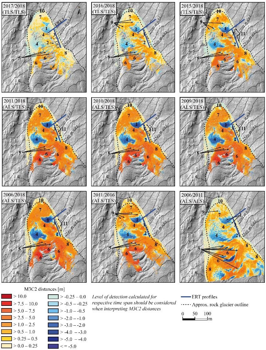
This combined approach reveals active and variable spatial and temporal surface dynamics in the investigated area, with minimum detectable change between 0.09 and 0.65 m at 95% confidence. Given that this approach overcomes current uncertainties in established methods of differentiating complex rock glacier surfaces, we consider it a valuable addition that can be applied to objects of similar properties such as landslides or glaciers.
Find all details in the full paper:
Zahs, V., Hämmerle, M., Anders, K., Hecht, S., Rutzinger, M., Sailer, R., Williams, J.G., Höfle, B. (2019): Multi-temporal 3D point cloud-based quantification and analysis of geomorphological activity at an alpine rock glacier using airborne and terrestrial LiDAR. Permafrost and Periglac Process. 2019;1-17. DOI: https://doi.org/10.1002/ppp.2004.
Research is continued…
Research at the active rock glacier Äußeres Hochebenkar is continued within the frame of two current research projects (AHK-4D, Geomorph4D) of the 3DGeo group.
- AHK-4D focuses on the development of a methodology to quantify the magnitudes and frequencies of individual surface change processes of a rock glacier over several years. We do this by analyzing three dimensional (3D) surface change based on high-resolution, high-frequency (bi-weekly) and multisource LiDAR data. Follow our updates on Twitter.
- Geomorph4D aims at exploring the importance of rockfalls and talus accumulation at the headwall of rock glaciers, and to examine this within the context of changing climate conditions, and therefore stresses, within paraglacial environments.
If you are interested in using LiDAR data acquired at the AHK rock glacier for your own research, you can find multi-temporal terrestrial laser scanning datasets openly provided on PANGAEA:
Pfeiffer, J., Höfle, B., Hämmerle, M., Zahs, V., Rutzinger, M., Scaioni, M., Lindenbergh, R., Oude Elberink, S., Pirotti, F., Bremer, M., Wujanz, D. & Zieher, T. (2019): Terrestrial laser scanning data of the Äußeres Hochebenkar rock glacier close to Obergurgl, Austria acquired during the Innsbruck Summer School of Alpine Research. PANGAEA. DOI: https://doi.pangaea.de/10.1594/PANGAEA.902042 .