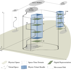
The production of Volunteered Geographic Information (VGI) is a type of human behavior which emerges via direct and indirect interactions with the physical environments described by these data. The nature of these interactions and the extent to which they rely on physical presence in the mapped area may affect the quality of the resulting digital representation, its completeness, and richness. Physical presence may also affect the formation of volunteer communities and their structures. For example, individual the contributions of individual M1 in the figure below, who is physically present in the area of interest, would probably reflect much local knowledge. This individual is also likely to develop place attachment which would encourage him/her to make repeated contributions. In comparison, by contributing from afar using an ancillary digital dataset, individual M2 may produce higher volumes of data. The richness of these however would rely on what information can be derived from the ancillary dataset. Hence, employing a space-time-behavior-based perspective for studying VGI may prove to be beneficial for understanding the characteristics of the data. In a recently accepted contribution to the VGI ALIVE workshop, time geographic concepts are reformulated for studying the production of VGI as a type of a physio-virtual behavior. The main one of these is the physio-virtual bundle – a space-time entity representing the conditions in physical and virtual spaces for a ‘data event’, i.e. a large-scale contribution over a short period of time. The nature of the bundle, derived from the characteristics of the relevant space-time domain, determines the nature of contributions. For example, changing accessibility conditions within the domain may determine the share of M1-like contributions in the data.
As a first step towards formalizing a broader analytical approach, these concepts are applied within the analysis of two case studies of OpenStreetMap (OSM) historical datasets – the city of Tel-Aviv Jaffa (TLV) in Israel and the Gaza Strip (GS). The first is characterized by high accessibility levels while in the other mobility in and out of the area is tightly regulated by military forces. Three different bundles were identified, one in TLV and two GS, with varying characteristics in terms of number of contributors, their location, and their motivation. The effects of these bundles on data quality are tightly related to conditions within the area and how these conditions shape community structures. For instance, more local knowledge (represented by number of tags) was included in the data when the area of interest was physically accessible; more regulation of the data was practiced when mapper communities presented a hierarchical structure with a core of highly involved mappers. The results thus show that bundles can have different characteristics and that these lead to different trends within the data, thus pointing towards possible formalizations of effects within the development of a broader analytical approach.
Hear the results and full story at VGI-ALIVE Workshop at AGILE 2018 (Lund, Sweden) and join the discussion there!
Grinberger, Y. (2018, accepted): Identifying the Effects of Mobility Domains on VGI: Towards an Analytical Approach. VGI-ALIVE Workshop at AGILE 2018. Lund, Sweden.


