

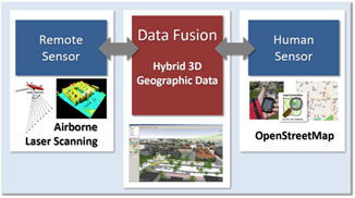
OpenStreetMap (OSM) currently represents the most popular project of Volunteered Geographic Information (VGI): geodata are collected by common people and made available for public use. Airborne Laser Scanning (ALS) enables the acquisition of high-resolution digital elevation models that are used for many applications.
Our new study combines the advantages of both ALS and OSM, offering a promising new approach that enhances data quality and allows change detection: the mainly up-to-date 2D data of OSM can be combined with the high-resolution – but rarely updated – elevation information provided by ALS.This case study investigates building objects of OSM and ALS data of the city of Bregenz, Austria. Data quality of OSM is discerned by the comparison of building footprints using different true positive definitions (e.g. overlapping area). High quality of OSM data is revealed, yet also limitations of each method with respect to heterogeneous regions and building outlines are identified. For the first time, an up-to-date Digital Surface Model (DSM) combining 2D OSM and ALS data is achieved. A multitude of applications such as flood simulations and solar potential assessments can directly benefit from this data combination, since their value and reliability strongly depend on an up-to-date DSM.
Reference: Klonner, C., Barron, C., Neis, P. & Höfle, B. (accepted): Updating digital elevation models via change detection and fusion of human and remote sensor data in urban environments. International Journal of Digital Earth. DOI: 10.1080/17538947.2014.881427.