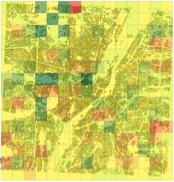
In the past years, several applications of generating 3D buildings from OpenStreetMap (OSM) have been made available, for instance, OSM-3D, OSM2World, etc. In these projects, 3D buildings are reconstructed using the buildings’ footprints and information about their attributes, which are documented as tags in OSM. Therefore, the quality of 3D buildings relies strongly on the quality of the building footprints data in OSM. The number of buildings soon approaches 100 million making it the most comprehensive data set for building footprints we know of. Our recent work is dedicated to a quality assessment of building footprints data in OSM. The data is evaluated in terms of completeness, semantic accuracy, position accuracy, and shape accuracy by using building footprints in ATKIS (German Authority Topographic-Cartographic Information System) as reference data for the German City of Munich, which is one of the most developed cities in OSM. The process contains three steps: finding correspondence between OSM and ATKIS data, calculating parameters of the four quality criteria, and statistical analysis. The results show that OSM footprint data in Munich has a high completeness and semantic accuracy. There is an offset of about four meters on average in terms of position accuracy. With respect to shape, OSM building footprints have a high similarity to those in ATKIS data. However, some architectural details are missing, hence, the OSM footprints can be regarded as a simplified version of those in ATKIS data.

more information: Fan H., Zipf A., Fu Q. and Neis P. (2013): Quality assessment for building footprints data on OpenStreetMap. International Journal of Geographical Information Science. DOI: 10.1080/13658816.2013.867495 (accepted).


