

Tag: Research
-
Evidence for Systematic Bias in the Spatial Memory of Large Language Models
Recent studies primarily view Large Language Models (LLMs) in geography as tools for linking natural language to geographic information systems. However, Roberts et al. (2023) demonstrated GPT-4’s inherent ability to perform spatial reasoning tasks without relying on external processing engines. This includes calculating the final destinations of routes based on initial locations, transport modes, directions,…
-
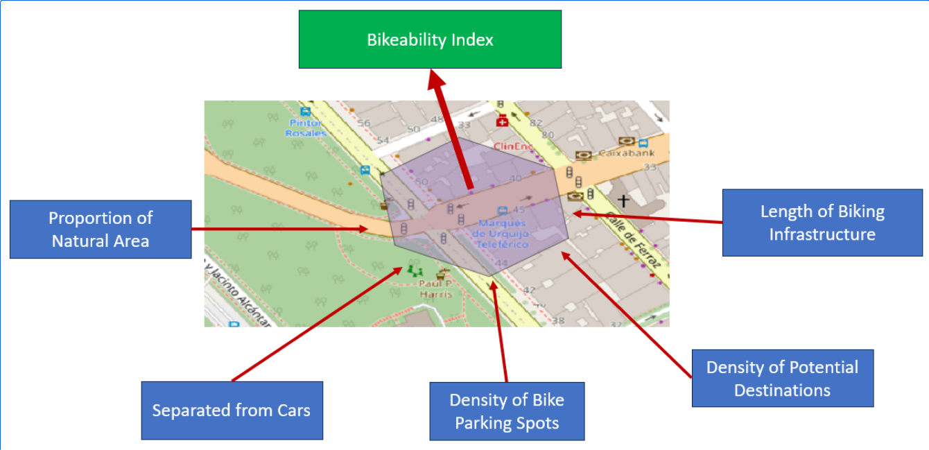
Analyzing Bikeability
For various reasons biking is becoming a more frequently used mode of transportation. It offers flexibility, is quite cheap compared to other modes of transportation, helps with fitness and is almost carbon neutral. To evaluate how well adapted the existing infrastructure is to accommodate biking, Manuel Kraft of HeiGIT created the “Bikeability-Index”. Analyzing Bikeability There…
-
Job Opening for Postdoc / Senior Researcher on OpenStreetMap Road Quality Analysis
If you’re on the job market or know someone who is, check out this exciting new opening at GIScience. The offer is included as text below! You are interested in enhancing methods for analyzing & improving OpenStreetMap data? You are an experienced Spatial Data Scientist innovating geoinformatics methods & workflows? You have profound hands-on experience…
-
New “Robert and Christine Danziger PhD Scholarships“ 2022 in Geoinformatics at GIScience Heidelberg University for PhD students from Africa – DL 15.July
It is our great pleasure to inform about the new “Robert and Christine Danziger Scholarships“ 2022 for doing a PhD in Geoinformatics at Heidelberg University. Please make yourself familiar with the research topics at GIScience Heidelberg and HeiGIT (e.g. projects, papers) when suggesting potential topics for your PhD research. Short facts: The Robert and Christine Danziger Scholarship is awarded to very…
-
Automatic mapping of national surface water with OpenStreetMap and Sentinel-2 MSI data using deep learning
Large-scale mapping activities can benefit from the vastly increasing availability of earth observation (EO) data, especially when combined with volunteered geographical information (VGI) using machine learning (ML). High-resolution maps of inland surface water bodies are important for water supply and natural disaster mitigation as well as for monitoring, managing, and preserving landscapes and ecosystems. In…
-
New publication on the Impact of Community Happenings in OpenStreetMap
Online knowledge projects such as OpenStreetMap (OSM) and Wikipedia have gained high importance, trust and even economic value. These projects and their content are maintained and enhanced by online communities that evolve around them. Yet, these communities and their members are often ignored when the respective data or knowledge is used. In a recent publication…
-
Constraints in multi-objective optimization of land use allocation – Repair or penalize?
Land is a spare resource so it makes sense to think about how to use it most efficiently. This leads to the problem of land use allocation under consideration of trade-offs. Multi-objective optimization algorithms are a tool quantify the trade-offs by estimating the Pareto-optimal land use allocations. Often, constraints in the solution space have to…
-
Talk on OpenStreetMap data quality at University of São Paulo, Brazil
During mid August and September, Amin Mobasheri had a short research visit to Institute of Mathematics and Computer Science (ICMC) at University of São Paulo, Brazil. Last week on 14th of September, he gave a presentation about “Open Geospatial Data Quality Assessment and Enrichment. The Case study of Routing and navigation services for people with limited…
-
PsychoGeography Project on Television
During the last decades, the epidemiological research has given indications that mental diseases can be related to socio-economic, as well as to environmental risk factors. In cooperation between the newly founded Psychiatric-Epidemiological Centrum (PEZ) at the Central Institute of Mental Health in Mannheim, the GIScience Research Group (Heidelberg University) and the Karlsruhe Institute of Technology…
-
Approach for Push-Based Result Transmission with Asynchronous Geospatial Processing
Geospatial analyses are increasingly being conducted in networked environments. In such cases, geographic analyses are carried out by leveraging ressources (including geospatial algorithms) on some remote server. A user might upload some dataset onto a server, triggers some geo-computation and awaits the results. Most of such web-based geo-processing services are implementing the so called “Web…
-
Lettering Maps by considering Basemap Detail
If you followed our previous posts (#1, #2) concerning high quality cartographic label placement, then this post is worthy of notice. Topographic maps are arguably one of the most information-dense, yet intuitively usable, graphical artifacts produced by mankind. Cartography as science and practice has developed and collected a wealth of design principles and techniques to…