Tag: deep learning
-

Deep learning with simulated laser scanning data for 3D point cloud classification
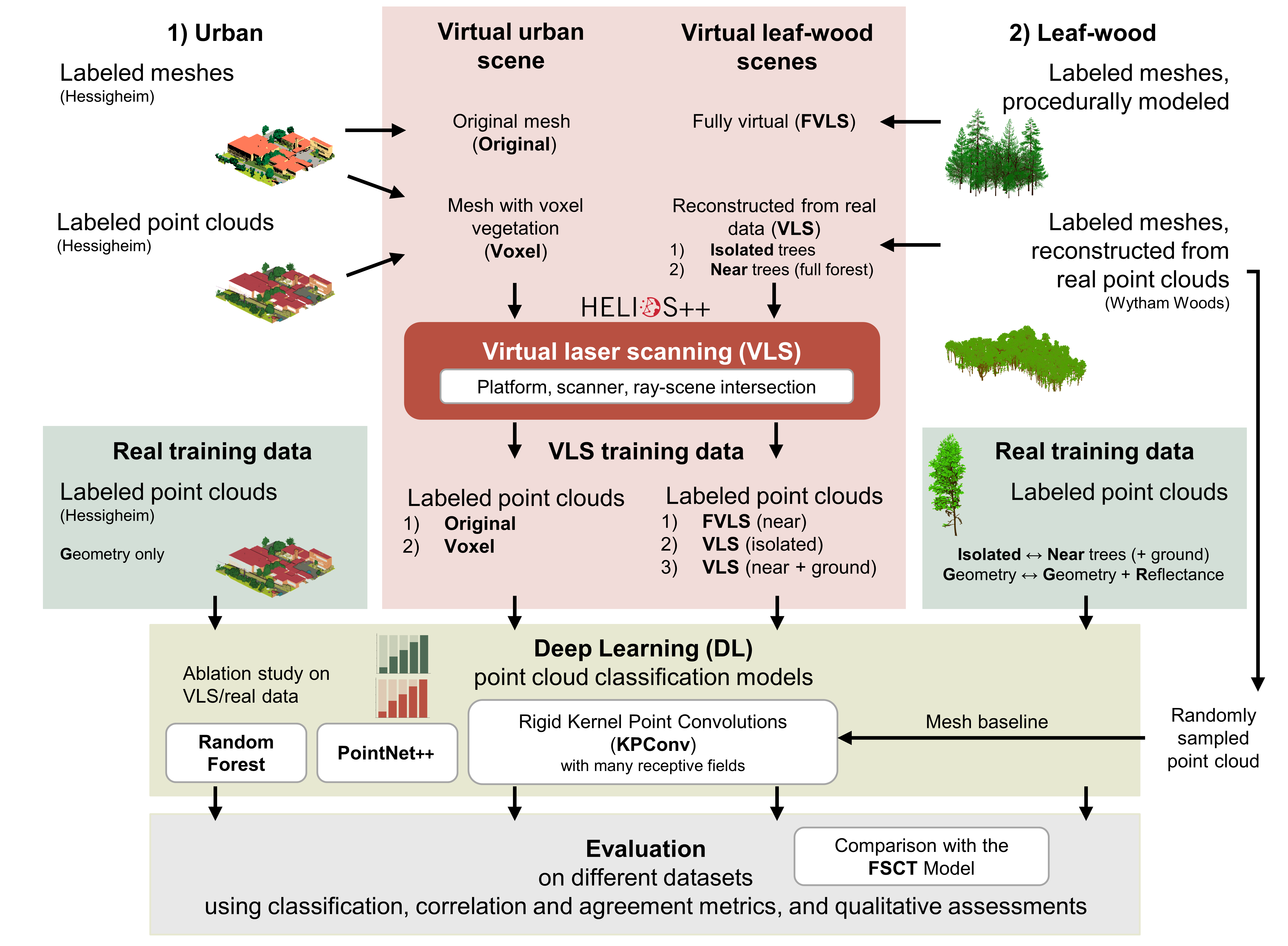
Esmorís, A.M., Weiser, H., Winiwarter, L., Cabaleiro, J.C. & Höfle, B. (2024): Deep learning with simulated laser scanning data for 3D point cloud classification. ISPRS Journal of Photogrammetry and Remote Sensing. Vol. 215, pp. 192-213. DOI: 10.1016/j.isprsjprs.2024.06.018 3D point clouds acquired by laser scanning are invaluable for the analysis of geographic phenomena. To extract information…
-

VirtuaLearn3D: New Preprint
We have published a preprint of our recent work in the VirtuaLearn3D project! Deep learning with simulated laser scanning data for 3D point cloud classification Esmorís, A.M., Weiser, H., Winiwarter, L., Cabaleiro, J.C. & Höfle, B. (2024) Laser scanning is an active remote sensing technique to acquire state-of-the-art spatial measurements in the form of 3D…
-
Job Offer: Deep Learning Engineer (m/f/d, up to 100%)
Are you a highly motivated individual who loves designing and developing machine learning and deep learning systems? Do you want to use your machine learning expertise for the benefit of society and the environment? Do you want to improve the availability and quality of geospatial data and further develop geoinformatics methods used for open, non-profit…
-
Leveraging OpenStreetMap and Multimodal Remote Sensing Data with Joint Deep Learning for Wastewater Treatment Plants Detection
Humans rely on clean water for their health, well-being, and various socio-economic activities. During the past few years, the COVID-19 pandemic has been a constant reminder of about the importance of hygiene and sanitation for public health. The most common approach to securing clean water supplies for this purpose is via wastewater treatment. To date,…
-
Online seminar ‘Deep learning from Volunteered Geographical Information: a case study of humanitarian mapping with OpenStreetMap’
We invite to the upcoming online seminar at the Urban Analytics Lab seminar series at the National University of Singapore (NUS): ‘Deep learning from Volunteered Geographical Information: a case study of humanitarian mapping with OpenStreetMap’ on 29 April (9am German time, 3pm Singapore time) By Hao Li, GIScience Research Group, Heidelberg University @GIScienceHD As an emerging topic,…
-
Where to map in OpenStreetMap next? Experiences from Mozambique, India, and Tonga
OpenStreetMap (OSM) has been intensively used to support humanitarian aid activities, especially in the Global South. Its data availability in the Global South has been greatly improved via recent humanitarian mapping campaigns and due to the efforts of local communities. However, large rural areas are still incompletely mapped. The timely provision of map data is…
-
Job Offer: “Lead: Geo Machine Learning for Good” Senior Spatial Data Science Expert (m, f, d) 100% permanent, HeiGIT gGmbH
Job advertisement HeiGIT gGmbH Do you want to use your machine learning expertise for the benefit of society and the environment? Do you want to improve the availability and quality of geospatial data and further develop geoinformatics methods used for open, non-profit applications in the field of sustainability, mobility and humanitarian aid? That’s our mission…
-
Job Offer: “Lead: Geo Machine Learning for Good”, Senior Spatial Data Science Expert (m, f, d), 100%, permanent, HeiGIT gGmbH
Du willst Deine Machine Learning Kompetenz zum Wohle der Gesellschaft und Umwelt einsetzen? Du willst die Verfügbarkeit und Qualität von Geodaten verbessern und geoinformatische Methoden weiterentwickeln, die für offene, gemeinnützige Anwendungen im Bereich Nachhaltigkeit, Mobilität und humanitäre Hilfe eingesetzt werden? Das ist auch unsere Mission! Die HeiGIT gGmbH ist ein forschungsorientiertes, gemeinnütziges Start-up mit den…
-
Stellenausschreibung Geoinformatik Heidelberg – Project GeCO: Generating high-resolution CO2 maps by Machine Learning-based geodata fusion
Stellenausschreibung Universität Heidelberg – GIScience Wissenschaftliche Mitarbeiter:in Geoinformatik – Projekt GeCO GeCO: Generating high-resolution CO2 maps by Machine Learning-based geodata fusion Du hast Interesse an Klimawandel, Treibhausgasemissionen und innovativen Geoinformatik-Methoden? Im Rahmen des vom Heidelberg Center for the Environment (HCE) durch die Exzellenzstrategie geförderten Kooperationsprojektes GeCO suchen wir baldmöglichst nach einer wissenschaftlichen Mitarbeiter:in (m/f/d). Die…
-
New Project: GeCO: Generating high-resolution CO2 maps by Machine Learning-based geodata fusion and atmospheric transport modelling
Recently a new project has been starting in the context of Climate Change Action research: GeCO: Generating high-resolution CO2 maps by Machine Learning-based geodata fusion and atmospheric transport modelling The spatiotemporal distribution of greenhouse gases and their sources on Earth has so far been considered mainly at relatively coarse resolutions. There is a lack of…
-
Automatic mapping of national surface water with OpenStreetMap and Sentinel-2 MSI data using deep learning
Large-scale mapping activities can benefit from the vastly increasing availability of earth observation (EO) data, especially when combined with volunteered geographical information (VGI) using machine learning (ML). High-resolution maps of inland surface water bodies are important for water supply and natural disaster mitigation as well as for monitoring, managing, and preserving landscapes and ecosystems. In…
-
GIScience and HeiGIT contributions to AGILE 2021 conference
The AGILE 2021 conference is taking place this week. It is the the 24rd AGILE conference on GIScience. AGILE is the Association of Geographic Information Laboratories in Europe and the 2021 conference is for the first time held as a virtual conference. As in earlier years GIScience Heidelberg and HeiGIT are contributing to the conference with several…


