
Search results for: “deep learning”
-
Stellenausschreibung Geoinformatik Heidelberg – Project GeCO: Generating high-resolution CO2 maps by Machine Learning-based geodata fusion
Stellenausschreibung Universität Heidelberg – GIScience Wissenschaftliche Mitarbeiter:in Geoinformatik – Projekt GeCO GeCO: Generating high-resolution CO2 maps by Machine Learning-based geodata fusion Du hast Interesse an Klimawandel, Treibhausgasemissionen und innovativen Geoinformatik-Methoden? Im Rahmen des vom Heidelberg Center for the Environment (HCE) durch die Exzellenzstrategie geförderten Kooperationsprojektes GeCO suchen wir baldmöglichst nach einer wissenschaftlichen Mitarbeiter:in (m/f/d). Die…
-
New Project: GeCO: Generating high-resolution CO2 maps by Machine Learning-based geodata fusion and atmospheric transport modelling
Recently a new project has been starting in the context of Climate Change Action research: GeCO: Generating high-resolution CO2 maps by Machine Learning-based geodata fusion and atmospheric transport modelling The spatiotemporal distribution of greenhouse gases and their sources on Earth has so far been considered mainly at relatively coarse resolutions. There is a lack of…
-
Detecting OpenStreetMap missing buildings by transferring pre-trained deep neural networks
Recently, a new research paper “Detecting OpenStreetMap missing buildings by transferring pre-trained deep neural networks” (Pisl, J., Li, H., Herfort, B., Lautenbach, S., Zipf, A. 2021) has been accepted at the the 24th AGILE conference 2021. The conference will take place virually on June 8 to 11, 2021. Accurate and complete geographic data of human…
-
Tagging the main entrances of public buildings based on OpenStreetMap and binary imbalanced learning
Determining the location of a building’s entrance is crucial to location-based services, such as wayfinding for pedestrians. Unfortunately, entrance information is often missing from current mainstream map providers. Frequently, automatic approaches for detecting building entrances are based on street-level images that are not widely available. To address this issue, in a recently published paper in…
-
E-TRAINEE project: E-learning course on Time Series Analysis in Remote Sensing
The E-TRAINEE project is a new collaboration project for developing an “E-learning course on Time Series Analysis in Remote Sensing for Understanding Human-Environment Interactions” with Markéta Potůčková (Department of Applied Geoinformatics and Cartography, Charles University Prague) as PI of the project and Heidelberg University, University of Innsbruck and University of Warsaw as project partners. The…
-
Estimating OpenStreetMap Missing Built-up Areas using Pre-trained Deep Neural Networks
Recently a new paper about Estimating OpenStreetMap Missing Built-up Areas using Pre-trained Deep Neural Networks (DNNs) has been presented at the AGILE GIScience conference 2019 in Cyprus. Although built-up areas cover only a small proportion of the earth’s surface, these areas are closely tied to most of the world’s population and the economic output, which makes…
-
Empower Humanitarian Mapping with Deep Neural Networks to Detect Human Settlements
Recently, earth observation by satellites has shown great capability in supporting a range of challenges such as disaster assessment, agriculture monitoring, and humanitarian mapping. MapSwipe, as a humanitarian mapping app, provides a crowdsourcing platform to collect volunteered geographical information (VGI), in order to generate the demanding base map of human settlements for better planning of…
-
Hyperspectral and LiDAR Fusion Using Deep Three-Stream Convolutional Neural Networks
Our feature paper “Hyperspectral and LiDAR Fusion Using Deep Three-Stream Convolutional Neural Networks” is now published online. Recently, convolutional neural networks (CNN) have been intensively investigated for the classification of remote sensing data by extracting invariant and abstract features suitable for classification. In this paper, a novel framework is proposed for the fusion of hyperspectral…
-
Mapping cultural ecosystem services 2.0 – using machine learning annotated photos to learn how humans perceive landscapes and ecosystems
Ecosystems provide many different services to mankind. Services provided depend on how the land is used – land use decisions lead to trade-offs that with respect to the ecosystem service provided by ecosystems and landscapes. This trade-offs vary in many situations in space and time. Therefore, it is essential to quantify and map service provisioning…
-
DeepVGI at HPI Future SOC Lab Day
Our research member Jiaoyan Chen attended the HPI Future SOC Lab Day – Spring 2017 in Potsdam, in April 25, 2017. The HPI Future SOC (Service-Oriented Computing) Lab Day is a cooperation of the Hasso Plattner Institute (HPI) and the industrial partners Dell EMC, Fujitsu, SAP and Hewlett Packard Enterprise (HPE). Its mission is to enable and promote exchange and…
-
DeepVGI at WWW2017 Perth
Our group member Jiaoyan Chen attended the 26th World Wide Web Conference from 3 April to 7 April in Perth, Australia. The topic of the conference includes web-related machine learning, social network, knowledge base, crowdsourcing, urban data mining, etc. He gave a 30-minues presentation in the co-conference Big 2017 as well as a poster presentation…
-
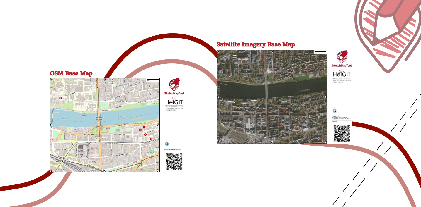
Unveiling the Sketch Map Tool 2.0: A Comprehensive Overview of New Features and Training Opportunities
The HeiGIT gGmbH (Heidelberg Institute for Geoinformation Technology) team has just released a version 2.0 of the Sketch Map Tool, a low-tech solution for participatory sketch mapping through offline data collection, digitization and georeferencing of local spatial knowledge. Thanks to continuous support from the German Red Cross and financial support by the German Federal Foreign Office, the HeiGIT tool has undergone significant enhancements. These updates introduce new features aimed…