

Category: Publications
-
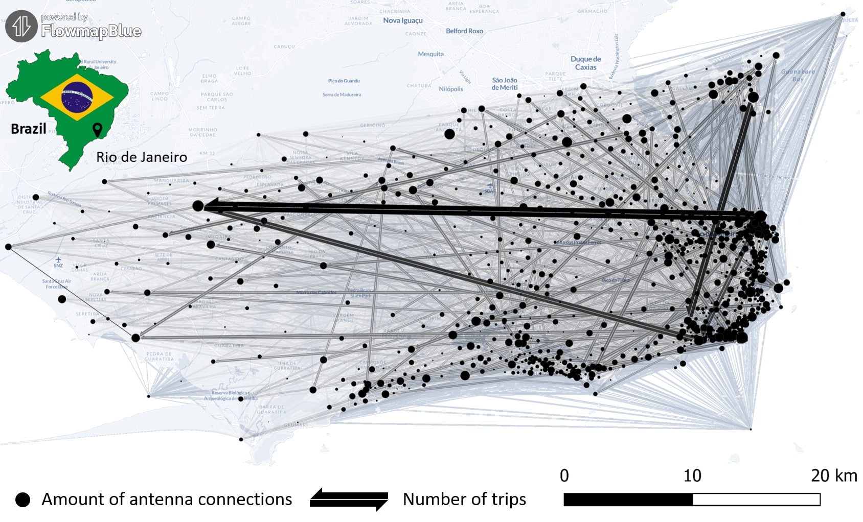
New Paper “Long-term validation of inner-urban mobility metrics derived from Twitter/X”
Data on mobility behavior can yield valuable insights that are beneficial for various applications such as public policy, emergency response, and urban planning. As the availability of freely-accessible mobility data is limited, the attention to X (formerly known as Twitter) as a data source has increased. Users of the platform can tag their online posts…
-
New Paper: GeoAI for Science and the Science of GeoAI
GeoAI integrates AI, geospatial big data, and high-performance computing for solving data- and computation-intensive geospatial problems. This field has gained continuous momentum, driven by strong demands in geography and the rapid advancement of AI. Wenwen Li´s paper “GeoAI for Science and the Science of GeoAI”, published in the latest edition of the Journal of Spatial…
-
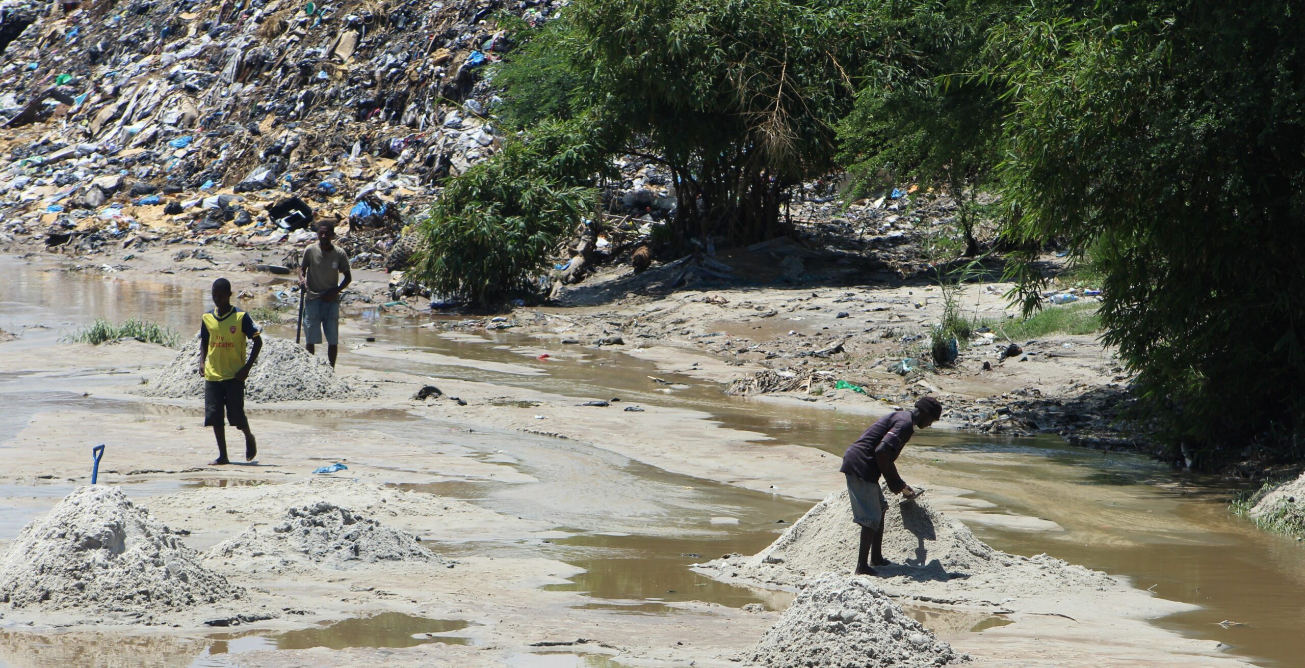
New Paper: “UAV-Assisted Municipal Solid Waste Monitoring for Informed Disposal Decisions”
Solid waste pollution is the cause of many environmental and health risks, especially in areas where waste is generated in large quantities but cannot be properly disposed of. Knowledge of the size and location of dump sites is required to keep waste management efficient and low-cost. When the extent of these dump sites needs to…
-
New Paper: “Enriching building function classification using Large Language Model embeddings of OpenStreetMap Tags”
Rapid global urbanization is placing immense pressure on planners to make informed decisions that promote sustainable growth. A crucial aspect of this challenge is understanding how urban buildings are used. Traditionally, classifying the function of buildings—such as residential or commercial—relies on costly and subjective on-site surveys. However, advances in AI are poised to transform this…
-
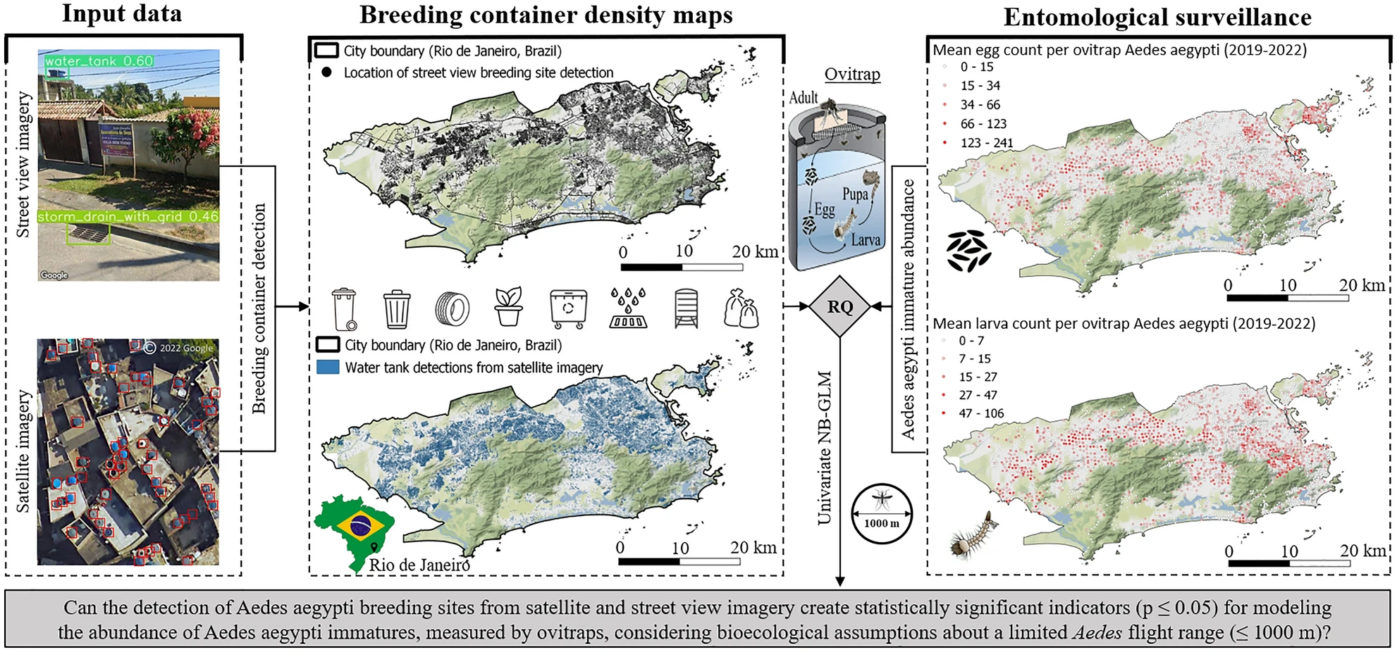
New Paper in Nature ‘Scientific Reports’: „High-resolution Mapping of Urban Aedes Aegypti Immature Abundance Through Breeding Site Detection Based on Satellite and Street View Imagery“
Knoblauch, S; Su Yin, M.; Chatrinan, Krittin; Rocha, Antonio A. de A.; Haddawy, P.; Biljecki, F.; Lautenbach, S.; Resch, B.; Arifi, D.; Jänisch, T.; Morales, I.; and Zipf, A published the paper ‘High-resolution mapping of urban Aedes aegypti immature abundance through breeding site detection based on satellite and street view imagery’ in Nature Scientific Reports.…
-
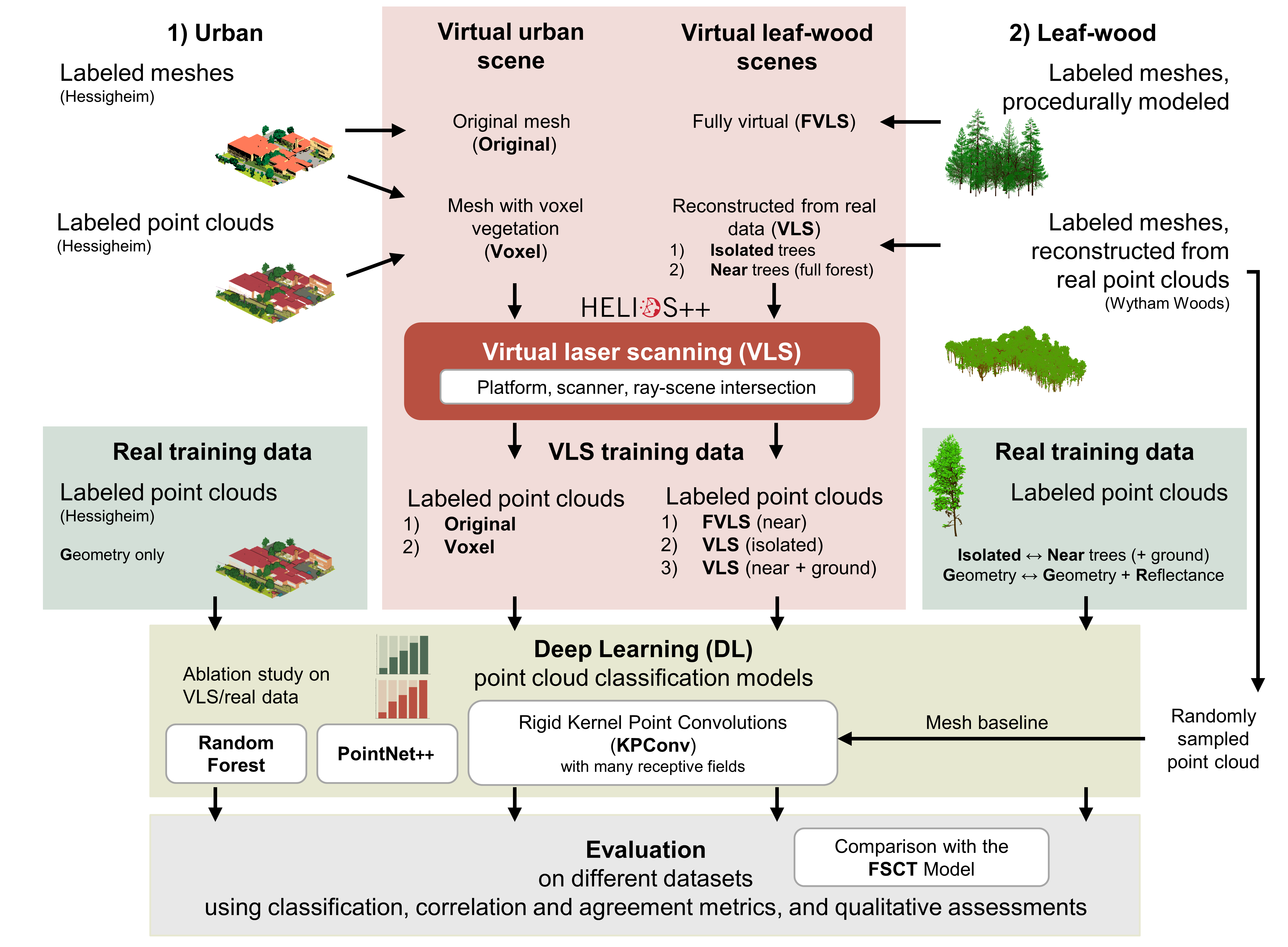
Deep learning with simulated laser scanning data for 3D point cloud classification
Esmorís, A.M., Weiser, H., Winiwarter, L., Cabaleiro, J.C. & Höfle, B. (2024): Deep learning with simulated laser scanning data for 3D point cloud classification. ISPRS Journal of Photogrammetry and Remote Sensing. Vol. 215, pp. 192-213. DOI: 10.1016/j.isprsjprs.2024.06.018 3D point clouds acquired by laser scanning are invaluable for the analysis of geographic phenomena. To extract information…
-
Evidence for Systematic Bias in the Spatial Memory of Large Language Models
Recent studies primarily view Large Language Models (LLMs) in geography as tools for linking natural language to geographic information systems. However, Roberts et al. (2023) demonstrated GPT-4’s inherent ability to perform spatial reasoning tasks without relying on external processing engines. This includes calculating the final destinations of routes based on initial locations, transport modes, directions,…
-

VirtuaLearn3D: New Preprint
We have published a preprint of our recent work in the VirtuaLearn3D project! Deep learning with simulated laser scanning data for 3D point cloud classification Esmorís, A.M., Weiser, H., Winiwarter, L., Cabaleiro, J.C. & Höfle, B. (2024) Laser scanning is an active remote sensing technique to acquire state-of-the-art spatial measurements in the form of 3D…
-
New paper on the potential of simulated laser scanning and field data to train forest biomass models
In great collaboration with colleagues from Karlsruhe (DE), Vienna (AT), Brno (CZ), Leipzig (DE), Raszyn (PL), and Berlin (DE), we published a paper investigating approaches to improve LiDAR-based biomass models when only limited sample plots with field data are available. The main work was carried out by PhD student Jannika Schäfer (IFGG, Karlsruhe Institute of…
-
More food, more water, less carbon? Costs andbenefits of global land-use optimality
Re-arranging food production: How we could use the vegetation zones on our planet more efficiently Imagine we could almost double the amount of crops we grow on our planet, while at the same time increasing the freshwater supplies and carbon storage! Tell you what: We actually could, if we re-arranged the location of food production…
-
New paper “Urban Heat Island Intensity Prediction in the Context of Heat Waves: An Evaluation of Model Performance”
Aner Martinez-Soto, Johannes Fürle and Alexander Zipf published the paper „Urban Heat Island Intensity Prediction in the Context of Heat Waves: An Evaluation of Model Performance“. It was presented at the 9th International Conference on Time Series and Forecasting in Gran Canaria, Spain, on 12th – 14th July 2023. Due to Climate Change urban heat…
-
New Publication in “Nature Communication” on the unequal distribution of building data in OSM
Benjamin Herfort and his colleagues Sven Lautenbach, João Porto de Albuquerque, Jennings Anderson and Alexander Zipf published an article in the renowned journal Nature Communications (Impact Factor 2023: 17.7). In their article, they address the uneven distribution of OpenStreetMap data worldwide, which can have an impact on research results and humanitarian operations. They provide solutions…